
| Counties of Hungary Magyarország vármegyéi (Hungarian) | |
|---|---|
 | |
| Category | Unitary state |
| Location | Hungary |
| Created |
|
| Number | 19 (as of 1950) |
| Additional status |
|
| Populations | 189,304 (Nógrád) – 1,278,874 (Pest) |
| Areas | 2,265 km2 (875 sq mi) (Komárom-Esztergom) – 8,445 km2 (3,261 sq mi) (Bács-Kiskun) |
| Government |
|
| Subdivisions |
|
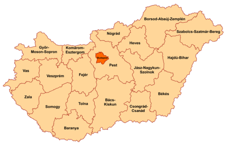
Hungary is subdivided administratively into 19 counties (vármegyék, singular: vármegye) and the capital city (főváros) Budapest. The counties are further subdivided into 174 districts (járások, singular: járás). The capital Budapest is subdivided into 23 districts (kerületek, singular: kerület).[1]
There are 25 cities with county rights (megyei jogú városok, singular: megyei jogú város), sometimes called urban counties. The local authorities of these towns have extended powers but they are not independent territorial units.
The current system of counties has evolved from medieval fiefdoms of the Kingdom of Hungary; each fiefdom was ruled from a castle (Hungarian: vár). Between 1950 and 2022, the counties of Hungary were officially called megyék (singular: megye). On January 1, 2023, the original historical name vármegye was officially restored.
YouTube Encyclopedic
-
1/5Views:751 583363347 0018 512503 247
-
Hungary - Geography, Regions, and Counties | Countries of the World
-
European kingdoms: politics, power and ethnicity (X century)
-
The Territorial Evolution Of HUNGARY
-
Romanian Counties vs Hungarian Counties, GDP per Capita, 1970-2026
-
10+ Surprising Facts About Hungary
Transcription
List of counties


There are seven towns with county's rights in addition to the county seats:
- Baja (Bács-Kiskun county)
- Dunaújváros (Fejér county)
- Esztergom (Komárom-Esztergom county)
- Érd (Pest county)
- Hódmezővásárhely (Csongrád-Csanád county)
- Nagykanizsa (Zala county)
- Sopron (Győr-Moson-Sopron county)
Codes of the counties
| County | ISO 3166-2[2] | NUTS[3] | Phone prefix[4] | Postal code[5] |
|---|---|---|---|---|
| Baranya | HU-BA | HU231 | 69, 72, 73 | 73xx, 75xx – 79xx |
| Bács-Kiskun | HU-BK | HU331 | 76, 77, 78, 79 | 60xx – 65xx |
| Békés | HU-BE | HU332 | 66, 68 | 55xx – 59xx |
| Borsod-Abaúj-Zemplén | HU-BZ | HU311 | 46, 47, 48, 49 | 34xx – 39xx |
| Budapest | HU-BU | HU101 | 1 | 1xxx |
| Csongrád-Csanád | HU-CS | HU333 | 62, 63 | 66xx – 69xx |
| Fejér | HU-FE | HU211 | 22, 25 | 206x, 209x, 24xx, 700x – 701x, 7041, 80xx, 811x – 815x |
| Győr-Moson-Sopron | HU-GS | HU221 | 96, 99 | 90xx – 94xx |
| Hajdú-Bihar | HU-HB | HU321 | 52, 54 | 40xx – 422x, 4241 – 4243, 425x – 429x |
| Heves | HU-HE | HU312 | 36, 37 | 300x – 304x, 32xx – 33xx |
| Jász-Nagykun-Szolnok | HU-JN | HU322 | 56, 57, 59 | 50xx – 54xx |
| Komárom-Esztergom | HU-KE | HU212 | 33, 34 | 2027 – 2028, 2067, 25xx, 28xx – 29xx |
| Nógrád | HU-NO | HU313 | 32, 35 | 2175 – 2179, 2610, 2611, 2616 – 2619, 264x – 269x, 304x – 31xx |
| Pest | HU-PE | HU102 | 23, 24, 26, 27, 28, 29, 53 | 20xx – 23xx, 2440, 2461, 260x – 263x, 2680 – 2683, 27xx |
| Somogy | HU-SO | HU232 | 82, 84, 85 | 7253 – 729x, 74xx – 75xx, 7918, 7977 – 7979, 86xx – 873x, 884x – 885x |
| Szabolcs-Szatmár-Bereg | HU-SZ | HU323 | 42, 44, 45 | 423x, 4244 – 4246, 4267, 43xx – 49xx |
| Tolna | HU-TO | HU233 | 74, 75 | 702x – 7252, 7352 – 7361 |
| Vas | HU-VA | HU222 | 94, 95 | 95xx – 99xx |
| Veszprém | HU-VE | HU213 | 87, 88, 89 | 810x, 816x – 819x, 830x – 8352, 84xx – 85xx |
| Zala | HU-ZA | HU223 | 83, 92, 93 | 8353 – 839x, 874x – 879x, 880x – 883x, 8855, 8856, 886x – 889x, 89xx |
See also
 |
|---|
- Regions of Hungary
- Districts of Hungary (from 2013) – Subregions of Hungary (until 2013)
- Ranked list of Hungarian counties
- List of cities and towns of Hungary
- NUTS:HU
- Administrative divisions of the Kingdom of Hungary (until 1918)
- Administrative divisions of the Kingdom of Hungary (1941–44)
Notes
- ^ Budapest is not a county, but a municipality that has an identical administrative status to all the other 19 counties.
References
- ^ a b c d Gazetteer of Hungary, 1 January 2019, Központi Statisztikai Hivatal, 2019, ISSN 1217-2952, retrieved 8 August 2021.
- ^ ISO 3166 Country Codes, International Organization for Standardization, retrieved 8 August 2021.
- ^ MAGYARORSZÁG – NU, European Commission, retrieved 8 August 2021.
- ^ Presentation of E.164 National Numbering Plan (NNP) for Hungary (country code +36), International Telecommunication Union, retrieved 8 August 2021.
- ^ Hungary Post Codes, WorldPostalCode, retrieved 8 August 2021.
External links
- Gazetteer of Hungary, 2012
- Gazetteer of Hungary, 1 January 2019
- ISO 3166 Country Codes
- MAGYARORSZÁG – NU
- Presentation of E.164 National Numbering Plan (NNP) for Hungary (country code +36)
| Authority control databases: National |
|---|