
Northborough, Massachusetts | |
|---|---|
 First Parish Church | |
 Flag  Seal | |
 Location in Worcester County and the state of Massachusetts. | |
| Coordinates: 42°19′10″N 71°38′30″W / 42.31944°N 71.64167°W | |
| Country | United States |
| State | Massachusetts |
| County | Worcester |
| Settled | 1672 |
| Incorporated | 1766 |
| Government | |
| • Type | Open town meeting |
| • Town Administrator | John W. Coderre |
| • Board of Selectmen | Mitch Cohen, Chair Julianne Hirsh, Vice Chair Kristen Wixted, Clerk T. Scott Rogers Jason Perreault |
| Area | |
| • Total | 18.8 sq mi (48.6 km2) |
| • Land | 18.5 sq mi (48.0 km2) |
| • Water | 0.2 sq mi (0.6 km2) |
| Elevation | 300 ft (91 m) |
| Population (2020) | |
| • Total | 15,741 |
| • Density | 840/sq mi (320/km2) |
| Demonym | Northboroners |
| Time zone | UTC−5 (Eastern) |
| • Summer (DST) | UTC−4 (Eastern) |
| ZIP Code | 01532 |
| Area code | 508 / 774 |
| FIPS code | 25-46820 |
| GNIS feature ID | 0618375 |
| Website | town.northborough.ma.us |
Northborough is a town in Worcester County, Massachusetts, United States. The official spelling of the town's name is "Northborough," but the alternative spelling "Northboro" is also used. The population was 15,741 at the 2020 census.[1]
YouTube Encyclopedic
-
1/4Views:15 7752 3213 512784
-
$5,000,000 Luxury Property in Northborough, Massachusetts, USA
-
Tougas family Farm - Northborough, Massachusetts
-
Driving from Worcester to Northboro,Massachusetts
-
9551: Lowe,s in Northborough, Massachusetts.
Transcription
History
The areas surrounding Northborough were first settled by the Nipmuc people.[2] Europeans set up a plantation on May 14, 1656, following a petition for resettlement from the people of the Sudbury Plantation to the General Court of the Bay Colony.[3] On January 24, 1766, the district of Northborough was established within neighboring Westborough. On August 23, 1775, the district became a town, and on June 20, 1807, part of neighboring Marlborough was annexed to Northborough.[4][5]
The first meeting house was established in 1746, with the legal governor of the town being called the Town Minister. The first Town Minister was Reverend John Martyn.
In 1775, Northborough split off as the "north borough" of Westborough, much as Westborough had split from Marlborough some 58 years before. However, the two towns shared a meetinghouse for some time more.
Geography
According to the United States Census Bureau, the town has a total area of 18.8 square miles (49 km2), of which 18.5 square miles (48 km2) is land and 0.2 square miles (0.52 km2), or 1.17%, is water. On average, the town is about 302 feet (92 meters) above sea level.
Adjacent towns and cities
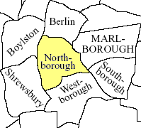
Northborough is located in Central Massachusetts, and shares a border with five towns and one city:
- Southborough is located to the southeast. The border, however, is only 500 yards long and is in the woods with no accessible trail.
- Marlborough is located to the north of Southborough and due east of Northborough. The most accessible way to enter Marlborough from Northborough is via U.S. Route 20.
- Berlin is located to the north of Northborough.
- Boylston is located to the northwest.
- Shrewsbury is located to the west, and is the town that separates Northborough from Worcester. Shrewsbury is accessible via Route 20 or Route 9.
- Westborough is located to the south of Northborough, and is accessible via Route 9 or Route 135
Of the six towns that make up Northborough's borders, and including Northborough as the seventh, Northborough is the fourth largest town by population. Marlborough is the largest while Berlin is the smallest.
Demographics
| Year | Pop. | ±% |
|---|---|---|
| 1860 | 1,565 | — |
| 1870 | 1,504 | −3.9% |
| 1880 | 1,676 | +11.4% |
| 1890 | 1,952 | +16.5% |
| 1900 | 2,164 | +10.9% |
| 1910 | 1,713 | −20.8% |
| 1920 | 1,753 | +2.3% |
| 1930 | 1,946 | +11.0% |
| 1940 | 2,382 | +22.4% |
| 1950 | 3,122 | +31.1% |
| 1960 | 6,687 | +114.2% |
| 1970 | 9,218 | +37.8% |
| 1980 | 10,568 | +14.6% |
| 1990 | 11,929 | +12.9% |
| 2000 | 14,013 | +17.5% |
| 2010 | 14,155 | +1.0% |
| 2020 | 15,741 | +11.2% |
| 2022 | 15,663 | −0.5% |
| Source: United States Census records and Population Estimates Program data.[6][7][8][9][10][11][12][13][14][15] | ||
By the 2010 census, the population had reached 14155. By the 2020 census, the population was 15,741.[16]
As of the census of 2000,[17] there were 14,013 people, 4,906 households, and 3,865 families residing in the town. The population density was 756.1 inhabitants per square mile (291.9/km2). There were 5,002 housing units at an average density of 269.9 per square mile (104.2/km2). The racial makeup of the town was 93.01% White, 0.65% Black or African American, 0.08% Native American, 5.05% Asian, 0.07% Pacific Islander, 0.36% from other races, and 0.78% from two or more races. Hispanic or Latino of any race were 1.28% of the population.
There were 4,906 households, out of which 43.4% had children under the age of 18 living with them, 68.9% were married couples living together, 7.6% had a female householder with no husband present, and 21.2% were non-families. 17.1% of all households were made up of individuals, and 6.2% had someone living alone who was 65 years of age or older. The average household size was 2.83 and the average family size was 3.22.
In the town, the population was spread out, with 29.5% under the age of 18, 4.5% from 18 to 24, 31.3% from 25 to 44, 25.0% from 45 to 64, and 9.8% who were 65 years of age or older. The median age was 37 years. For every 100 females, there were 96.8 males. For every 100 females age 18 and over, there were 93.0 males.
The median income for a household in the town was $99,781, and the median income for a family was $120,480. Males had a median income of $65,437 versus $51,042 for females. The per capita income for the town was $42,889. About 1.7% of families and 2.8% of the population were below the poverty line, including 2.0% of those under age 18 and 9.3% of those age 65 or over.
Government
| State government | |
|---|---|
| State Representative(s): | Harold P. Naughton Jr. (D), Danielle Gregoire (D) |
| State Senator(s): | Harriette L. Chandler (D-1st Worcester district), Jamie Eldridge (D) |
| Governor's Councilor(s): | Jen Caissie (R), Marilyn M. Petitto Devaney (D) |
| Federal government | |
| U.S. Representative(s): | 2nd District |
| U.S. Senators: | Elizabeth Warren (D), Ed Markey (D) |
Library

The Northborough Free Library was established in 1868.[18][19] In fiscal year 2009, the town of Northborough spent 1.5% ($645,208) of its budget on its public library—approximately $43.41 per person, per year ($53.36 adjusted for inflation to 2021).[20]
Education
Public schools
The Northborough-Southborough Public School District is home to four public elementary schools serving grades pre-kindergarten through grade 5. They include Lincoln Street School, Marguerite E. Peaslee School, Fannie E. Proctor School, and Marion E. Zeh school.
In 2002, the Northborough Middle School was renamed after former superintendent of schools, Robert E. Melican.
The public high school serving Northborough is Algonquin Regional High School, and is shared with Southborough. The mascot for Northborough-Southborough students was the Tomahawk, but was officially changed to the Titans in early 2022. Debates have erupted over whether Northborough and Southborough should have separate high schools; however, citizens of both Northborough and Southborough successfully fought to keep the school regionalized. Assabet Valley Regional Technical High School is an alternate choice for Northborough students.
Private schools
Private schools include The Cornerstone Academy, a private elementary school, and Saint Bernadette School, a private Roman Catholic elementary and middle school.
Sports
The New England Baseball Complex is located at the intersection of Route 20 and Route 9 in Northborough. The newly built complex is home to the New England Ruffnecks, a youth baseball association. Many high schools, including Algonquin have had MIAA games at the NEBC. Regional colleges and universities have hosted opponents at the New England Baseball Complex. Their little league of Algonquin shared with Southborough is open to any children. The local middle school, Robert E. Melican Middle School, has sports teams for 7th graders and up.
Notable people
- Joseph Allen, pastor
- Joseph Henry Allen, (August 21, 1820 – March 20, 1898) Unitarian minister and scholar[21]
- William Francis Allen, (September 5, 1830 – December 9, 1899) classical scholar[21]
- Mark Fidrych, (August 14, 1954 – April 13, 2009), former pitcher for the Detroit Tigers and 1976 American League Rookie of the Year
- John Kellette, (June 1873 – August 7, 1922) an American songwriter, wrote the song "I'm Forever Blowing Bubbles" in 1918[22]
- Meghan Kilcoyne, member of the Massachusetts House of Representatives for the 12th Worcester district, resides in Northborough
- Dorian McMenemy, (born October 28, 1996) Olympic swimmer for the Dominican Republic[23]
- Gregory Goodwin Pincus, (April 9, 1903 – August 22, 1967) one of the three "fathers" of the birth control pill[24]
- Jon Radoff, (born September 17, 1972) internet entrepreneur and author
- Nathaniel Raymond, (born November 11, 1977) an American human rights investigator, specializing in the investigation of war crimes
- Luther Rice, (25 March 1783 – 27 September 1836) American Baptist minister and founder of George Washington University
- Mike Sherman, (born December 19, 1954) coach of the Montreal Alouettes of the Canadian Football League; former head coach of the Green Bay Packers
- Daniel Baird Wesson, (May 18, 1825 – August 4, 1906) American inventor and firearms designer; co-founder of the Smith & Wesson gun manufacturing company
Media
Newspapers
- Metrowest Daily News
- Worcester Telegram and Gazette[25]
- Community Advocate[26]
- Northborough/Southborough Villager[27] (weekly)
- Northborough Patch[28] (online)
References
- ^ "Census - Geography Profile: Northborough town, Worcester County, Massachusetts". United States Census Bureau. Retrieved November 11, 2021.
- ^ "NIAC Publications ~ Nipmuc Place Names – Territory and Language". nativetech.org.
- ^ Josiah Coleman Kent (1921). Northborough History. Garden City Press, Incorporated, printers.
- ^ Record Commission, Massachusetts (1889). "First- Thirty Second Report of the Commissioner of Public Records ..." google.com.
- ^ The annexation was requested by Jonas Bartlett, whose property straddled the border between the two towns. The minutes of town meetings for both towns record the change, which redrew the boundary to conform to Bartlett's property line.
- ^ "TOTAL POPULATION (P1), 2010 Census Summary File 1, All County Subdivisions within Massachusetts". United States Census Bureau. Archived from the original on February 12, 2020. Retrieved September 13, 2011.
- ^ "Massachusetts by Place and County Subdivision – GCT-T1. Population Estimates". United States Census Bureau. Archived from the original on February 12, 2020. Retrieved July 12, 2011.
- ^ "1990 Census of Population, General Population Characteristics: Massachusetts" (PDF). US Census Bureau. December 1990. Table 76: General Characteristics of Persons, Households, and Families: 1990. 1990 CP-1-23. Archived from the original (PDF) on December 7, 2013. Retrieved July 12, 2011.
- ^ "1980 Census of the Population, Number of Inhabitants: Massachusetts" (PDF). US Census Bureau. December 1981. Table 4. Populations of County Subdivisions: 1960 to 1980. PC80-1-A23. Retrieved July 12, 2011.
- ^ "1950 Census of Population" (PDF). 1: Number of Inhabitants. Bureau of the Census. 1952. Section 6, Pages 21–10 and 21-11, Massachusetts Table 6. Population of Counties by Minor Civil Divisions: 1930 to 1950. Retrieved July 12, 2011.
{{cite journal}}: Cite journal requires|journal=(help) - ^ "1920 Census of Population" (PDF). Bureau of the Census. Number of Inhabitants, by Counties and Minor Civil Divisions. Pages 21–5 through 21-7. Massachusetts Table 2. Population of Counties by Minor Civil Divisions: 1900, 1910, and 1920. Retrieved July 12, 2011.
- ^ "1890 Census of the Population" (PDF). Department of the Interior, Census Office. Pages 179 through 182. Massachusetts Table 5. Population of States and Territories by Minor Civil Divisions: 1880 and 1890. Retrieved July 12, 2011.
- ^ "1870 Census of the Population" (PDF). Department of the Interior, Census Office. 1872. Pages 217 through 220. Table IX. Population of Minor Civil Divisions, &c. Massachusetts. Retrieved July 12, 2011.
- ^ "1860 Census" (PDF). Department of the Interior, Census Office. 1864. Pages 220 through 226. State of Massachusetts Table No. 3. Populations of Cities, Towns, &c. Retrieved July 12, 2011.
- ^ "City and Town Population Totals: 2020-2022". United States Census Bureau. Retrieved November 23, 2023.
- ^ "U.S Census Buereau Quickfacts: Northborough town, Worcester County, Massachusetts; United States". Retrieved August 13, 2021.
- ^ "U.S. Census website". United States Census Bureau. Retrieved January 31, 2008.
- ^ C.B. Tillinghast. The free public libraries of Massachusetts. 1st Report of the Free Public Library Commission of Massachusetts. Boston: Wright & Potter, 1891. Google books
- ^ "Untitled Document". northboroughlibrary.org. Archived from the original on December 17, 2010. Retrieved November 10, 2010.
- ^ July 1, 2008 through June 30, 2009; cf. The FY2009 Municipal Pie: What’s Your Share? Commonwealth of Massachusetts, Board of Library Commissioners. Boston: 2010. Available: Municipal Pie Reports Archived January 23, 2012, at the Wayback Machine. Retrieved 2011-11-11
- ^ a b Who Was Who in America, Historical Volume, 1607–1896. Marquis Who's Who. 1967.
- ^ "Northboro Chorus revels in 'Blowing Bubbles'".
- ^ Rick Rendell/Daily News staff. "London calling for Northborough's McMenemy". MetroWest Daily News, Framingham, MA.
- ^ "Dr. Pincus, Developer of Birth-Control Pill, Dies". The New York Times. August 23, 1967. Retrieved July 21, 2007.
Dr. Gregory Goodwin Pincus, one of the three "fathers" of the birth-control pill, died here tonight at Peter Bent Brigham Hospital of myeloid metaplasia, a rare blood disease. He was 64 years old and lived in Northboro.
- ^ "Home – telegram.com – Worcester, MA". telegram.com.
- ^ "Town of Northborough in Massachusetts". communityadvocate.com. Archived from the original on October 21, 2017. Retrieved August 22, 2013.
- ^ "Home – The Villager – Northborough, MA". The Villager.
- ^ "Northborough, MA Patch – Local News, Community, Sports, Shopping, Restaurants, Things To Do". Northborough, Massachusetts Patch.
External links

| International | |
|---|---|
| National | |
| Geographic | |
| Other | |