
Shiloh Valley Township | |
|---|---|
Township | |
 The Knobeloch-Seibert Farm west of Mascoutah | |
 Location in St. Clair County | |
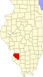 St. Clair County's location in Illinois | |
| Country | |
| State | |
| County | |
| Established | Unknown |
| Area | |
| • Total | 31.89 sq mi (82.6 km2) |
| • Land | 31.68 sq mi (82.1 km2) |
| • Water | 0.21 sq mi (0.5 km2) 0.66% |
| Population (2010) | |
| • Estimate (2016)[1] | 11,662 |
| • Density | 367.1/sq mi (141.7/km2) |
| Time zone | UTC-6 (CST) |
| • Summer (DST) | UTC-5 (CDT) |
| FIPS code | 17-163-69550 |
Shiloh Valley Township is located in St. Clair County, Illinois. As of the 2010 census, its population was 11,631 and it contained 4,284 housing units.[2] Shiloh Valley Township was originally called Shiloh before its name was changed on an unknown date.
Geography
According to the 2010 census, the township has a total area of 31.89 square miles (82.6 km2), of which 31.68 square miles (82.1 km2) (or 99.34%) is land and 0.21 square miles (0.54 km2) (or 0.66%) is water.[2]
Demographics
| Census | Pop. | Note | %± |
|---|---|---|---|
| 2016 (est.) | 11,662 | [1] | |
| U.S. Decennial Census[3] | |||
References
- ^ a b "Population and Housing Unit Estimates". Retrieved June 9, 2017.
- ^ a b "Population, Housing Units, Area, and Density: 2010 - County -- County Subdivision and Place -- 2010 Census Summary File 1". United States Census. Archived from the original on February 12, 2020. Retrieved May 28, 2013.
- ^ "Census of Population and Housing". Census.gov. Retrieved June 4, 2016.
External links
Municipalities and communities of St. Clair County, Illinois, United States | ||
|---|---|---|
| Cities |  | |
| Villages | ||
| Townships | ||
| CDPs | ||
| Other unincorporated communities | ||
| Footnotes | ‡This populated place also has portions in an adjacent county or counties | |
38°31′34″N 89°52′25″W / 38.52611°N 89.87361°W
| International | |
|---|---|
| National | |
This St. Clair County, Illinois location article is a stub. You can help Wikipedia by expanding it. |