
Halfmoon | |
|---|---|
| Town of Halfmoon | |
 The Thaddeus Kosciusko Bridge connects Halfmoon in Saratoga County to Colonie in Albany County, New York, over the Mohawk River. | |
 Flag | |
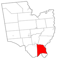 Location within Saratoga County | |
 Halfmoon Location within the state of New York | |
| Coordinates: 42°51′24″N 73°44′33″W / 42.85667°N 73.74250°W | |
| Country | United States |
| State | New York |
| County | Saratoga |
| Settled | 1788 |
| Named for | Halve Maen |
| Government | |
| • Supervisor | Kevin Tollisen (R) |
| Area | |
| • Total | 33.63 sq mi (87.10 km2) |
| • Land | 32.58 sq mi (84.38 km2) |
| • Water | 1.05 sq mi (2.72 km2) |
| Elevation | 282 ft (86 m) |
| Population (2020) | |
| • Total | 25,662 |
| • Density | 787.66/sq mi (304.12/km2) |
| Time zone | UTC-5 (Eastern (EST)) |
| • Summer (DST) | UTC-4 (EDT) |
| ZIP code | 12065 & 12118 |
| Area code | 518 |
| FIPS code | 36-31489 |
| GNIS feature ID | 0979035 |
| Website | Town website |
Halfmoon is a town in Saratoga County, New York, United States. The population was 25,662 at the 2020 census. The town is apparently named for the shape of the lower elevation land north of the junction of the Hudson and Mohawk Rivers. It is also said to be named for Henry Hudson's ship, the Halve Maen.
Halfmoon is in the southeastern part of the county and is north of Albany.
YouTube Encyclopedic
-
1/5Views:2 061117 92496 8228 044389
-
The Half Moon Replica
-
Arriving in the Bahamas at the port of Half Moon Cay
-
Half Moon
-
Peking Sail Ship leaves pier16@South Street Seaport NY 09-07-2016
-
Cargo and Cuisine on the Half Moon
Transcription
We're standing next to a replica of the Half Moon, the very ship that sailed up this river 400 years ago with Henry Hudson and his crew. We're going to be speaking with the captain of the replica, Chip Reynolds. Let's see what he has inside. Give us an outlay real quick about the dimensions of the ship. How big is it from front to back, how wide is it, how tall are the masts? Well you're looking at a vessel that's just over 100 tons in modern terms and the extreme length from the sprit to the transom is about 100 feet. The mast height goes up to about 87 feet. The hull length itself is right around 85 and the keel length is something more like 65 feet. The breath of the ship is about 18 feet. So it's a very commodious vessel but as you look around it you begin to see that the greatest volume is in the hole, that is the lowest level below the ship. What makes sense this is a commercial vessel. It's job is trade so they need that hole space to carry the commodities that they're trading for. On Hudson's voyage it was not so much trade, although they did engage in some minor trade just to see wether the opportunity for trade existed here. But in addition to the commodities they're bringing back, the spices and such like that, they also needed to have capacity for all their spare gear, fuel, the beer, the water, the meat, and the fish they were carrying as well as spare wood, ship's boat that might have been prefabricated and the pieces assembled down below deck. Everything had to be backed up on here. The Half Moon had no blueprints. How is it possible that we are able to recreate a ship 400 years after the fact with no blueprints? Well in the 17th century, shipwrights did not build to blueprints, they built to rule of thumb. So they established the cargo carrying capacity of the vessel and from that all the other measures were very standard and they were proportional to both the tonnage and the keel length of the vessel. So we have the original contract of the vessel that specifies its tonnage in Dutch measure called 'last' and from that we can project what the size of the vessel would have been. Furthermore there is extensive documentation about this particular style of vessel, the Dutch Yacht. These vessels were well documented in artwork of the time and also in the narrative record that gives us the items that were aboard the ship, the navigational instruments used, the accommodations that were found on here. So the entire rig you see here, the shape of the ship, the designs that are found on the vessel, the coloration that is used is all documentable through the artwork of that time period. We know very clearly that in this first decade of the 1600s, ship building was exploding because the profits that were to be made out of this particular enterprise, there was tremendous incentive for the East India Company to find more efficient routes. That is those that are less vulnerable to piracy, the extremes of weather to the depredation on the crew from nutritional diseases when they were underway. And thus Henry Hudson comes into play here as someone who is exploring these alternate routes and looking for a way to get that more efficient route to the Indies for the East India Company.
History
The earliest settlements took place circa 1680 by the Mohawk River.
The town was formed while still part of Albany County in 1788. The name was briefly changed to Orange when the town of Waterford was created in 1816 from part of Halfmoon; however, the current name was restored in 1820. In 1828, the western portion of the town was used to create the town of Clifton Park.
The Erie Canal was built along the southern part of Halfmoon, part of the Mohawk River.[2]
Geography
According to the United States Census Bureau, the town has a total area of 33.7 square miles (87 km2), of which 32.7 square miles (85 km2) is land and 1.0 square mile (2.6 km2) (3.00%) is water.
The southern town line, delineated by the Mohawk River, is the border of Albany County. The eastern town line, at the Hudson River, is the border of Rensselaer County. The northern town line is marked by the Anthony Kill, a tributary of the Hudson River.
Interstate 87, the Adirondack Northway, is a six-lane north–south freeway along the western edge of Halfmoon. U.S. Route 9 parallels the interstate farther to the east and crosses into the town from Albany County on the Crescent Bridge. New York State Route 146, an east–west highway, intersects US-9 at the hamlet of Clifton Park. U.S. Route 4 is a north–south highway in the eastern part of the town. New York State Route 236 is a short state highway linking NY-146 to US-9.
Demographics
| Census | Pop. | Note | %± |
|---|---|---|---|
| 1820 | 4,024 | — | |
| 1830 | 2,042 | −49.3% | |
| 1840 | 2,631 | 28.8% | |
| 1850 | 2,788 | 6.0% | |
| 1860 | 3,130 | 12.3% | |
| 1870 | 3,093 | −1.2% | |
| 1880 | 3,102 | 0.3% | |
| 1890 | 3,732 | 20.3% | |
| 1900 | 5,101 | 36.7% | |
| 1910 | 5,980 | 17.2% | |
| 1920 | 1,534 | −74.3% | |
| 1930 | 1,739 | 13.4% | |
| 1940 | 1,969 | 13.2% | |
| 1950 | 2,836 | 44.0% | |
| 1960 | 4,120 | 45.3% | |
| 1970 | 9,287 | 125.4% | |
| 1980 | 11,860 | 27.7% | |
| 1990 | 13,879 | 17.0% | |
| 2000 | 18,474 | 33.1% | |
| 2010 | 21,535 | 16.6% | |
| 2020 | 25,662 | 19.2% | |
U.S. Decennial Census[3] | |||
As of the census[4] of 2000, there were 18,474 people, 7,778 households, and 4,861 families residing in the town. The population density was 565.9 inhabitants per square mile (218.5/km2). There were 8,172 housing units at an average density of 250.3 per square mile (96.6/km2). The racial makeup of the town was 94.94% White, 1.27% African American, 0.17% Native American, 1.89% Asian, 0.02% Pacific Islander, 0.41% from other races, and 1.30% from two or more races. Hispanic or Latino of any race were 1.65% of the population.
There were 7,778 households, out of which 30.3% had children under the age of 18 living with them, 49.9% were married couples living together, 9.0% had a female householder with no husband present, and 37.5% were non-families. 29.1% of all households were made up of individuals, and 7.1% had someone living alone who was 65 years of age or older. The average household size was 2.35 and the average family size was 2.93.
In the town, the population was spread out, with 23.7% under the age of 18, 6.9% from 18 to 24, 36.3% from 25 to 44, 22.5% from 45 to 64, and 10.6% who were 65 years of age or older. The median age was 36 years. For every 100 females, there were 94.7 males. For every 100 females age 18 and over, there were 91.4 males.
The median income for a household in the town was $46,234, and the median income for a family was $53,515. Males had a median income of $40,076 versus $30,512 for females. The per capita income for the town was $23,714. About 3.7% of families and 4.5% of the population were below the poverty line, including 5.6% of those under age 18 and 6.4% of those age 65 or over.
Notable people
- Chauncey Boughton, physician and New York State Assembly member
- Daniel G. Garnsey, former US Congressman
Education
The Town of Halfmoon falls within three school districts:[5]
- Mechanicville City School District
- Shenendehowa Central School District
- Waterford-Halfmoon Union Free School District
Communities and locations in Halfmoon
- Coons – A hamlet near the northern town line, west of Mechanicville.
- Crescent – A hamlet in the southern part of the town.
- Halfmoon (formerly “Middletown”) – The hamlet of Halfmoon is in the southern part of the town at the junction of County Roads 94, 95, 96, and 99.
- Halfmoon Beach – A riverbank hamlet in the southwestern corner of the town.
- Grays Corners – A location in the southwestern part of the town.
- Newtown – A hamlet in the northeastern part of the town on NY-146.
- Smithtown – A former community south of Newtown.
References
- ^ "2016 U.S. Gazetteer Files". United States Census Bureau. Retrieved July 5, 2017.
- ^ "The Erie Canal in Halfmoon & Clifton Park · The Erie Canal in Saratoga County · The Erie Canal in Saratoga County". cpheriecanal.omeka.net. Retrieved May 28, 2024.
- ^ "Census of Population and Housing". Census.gov. Retrieved June 4, 2015.
- ^ "U.S. Census website". United States Census Bureau. Retrieved January 31, 2008.
- ^ "School Payments". Town of Halfmoon, New York. Retrieved July 24, 2002.
External links
Municipalities and communities of Saratoga County, New York, United States | ||
|---|---|---|
| Cities |  | |
| Towns | ||
| Villages | ||
| CDPs | ||
| Other hamlets | ||
| Footnotes | ‡This populated place also has portions in an adjacent county or counties | |

| International | |
|---|---|
| National | |