
Mühldorf | |
|---|---|
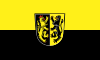 Flag 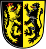 Coat of arms | |
 | |
| Country | Germany |
| State | Bavaria |
| Adm. region | Upper Bavaria |
| Capital | Mühldorf |
| Government | |
| • District admin. | Maximilian Heimerl (CSU) |
| Area | |
| • Total | 805.32 km2 (310.94 sq mi) |
| Population (31 December 2022)[1] | |
| • Total | 119,878 |
| • Density | 150/km2 (390/sq mi) |
| Time zone | UTC+01:00 (CET) |
| • Summer (DST) | UTC+02:00 (CEST) |
| Vehicle registration | MÜ |
| Website | landkreis-muehldorf.de |
Mühldorf is a Landkreis (district) in Upper Bavaria, Germany. It is bounded by (from the north and clockwise) the districts of Landshut, Rottal-Inn, Altötting, Traunstein, Rosenheim, Ebersberg and Erding.
YouTube Encyclopedic
-
1/1Views:515
-
The last Battle of Knights | Who will be the Emperor? (Middle Ages, Knights, Battles)
Transcription
History
Most parts of the district have belonged to Bavaria from the 13th century on. The archbishopric of Salzburg possessed some estates in the region as well from the year 798.[2] In 1803, when the clerical states of Holy Empire were dissolved, Bavaria annexed these estates.
Geography
The district is located in generally plain countryside on either bank of the river Inn.
Coat of arms
The coat of arms displays:
- the heraldic lion of Salzburg
- the heraldic lion of the Electorate of the Palatinate
Towns and municipalities

| Towns | Municipalities | |
|---|---|---|
References
- ^ Genesis Online-Datenbank des Bayerischen Landesamtes für Statistik Tabelle 12411-003r Fortschreibung des Bevölkerungsstandes: Gemeinden, Stichtag (Einwohnerzahlen auf Grundlage des Zensus 2011)
- ^ Freed, p. 13
Bibliography
Freed, John B. Noble Bondsmen: Ministerial Marriages in the Archdiocese of Salzburg, 1100-1343. (Ithaca, NY: Cornell University Press, 1995).
External links
- Official website (German)
48°15′N 12°25′E / 48.25°N 12.42°E
| International | |
|---|---|
| National | |