
Dingolfing-Landau | |
|---|---|
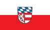 Flag 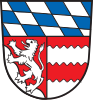 Coat of arms | |
 | |
| Country | Germany |
| State | Bavaria |
| Adm. region | Lower Bavaria |
| Capital | Dingolfing |
| Government | |
| • District admin. | Werner Bumeder (CSU) |
| Area | |
| • Total | 878 km2 (339 sq mi) |
| Population (31 December 2022)[1] | |
| • Total | 100,306 |
| • Density | 110/km2 (300/sq mi) |
| Time zone | UTC+01:00 (CET) |
| • Summer (DST) | UTC+02:00 (CEST) |
| Vehicle registration | DGF, LAN |
| Website | lra-dgf.bayern.de |
Dingolfing-Landau is a Landkreis (district) in Bavaria, Germany. It is bounded by (from the north and clockwise) the districts of Straubing-Bogen, Deggendorf, Rottal-Inn and Landshut.
YouTube Encyclopedic
-
1/2Views:43211 464
-
So läuft die Ausbildung beim Kreisbauhof Dingolfing-Landau
-
++ALARM++WARNEN DER BEVÖLKERUNG+ LANDKREIS DINGOLFING-LANDAU
Transcription
History
The district was established in 1972 by merging the former districts of Dingolfing and Landau (Isar). Its original name was Untere Isar ("Lower Isar"), but in 1973 it was renamed and got its present name.
Geography
The region is characterised by very plain countryside and several rivers running from southwest to northeast (towards the Danube). Most important rivers of the district are the Isar and the Vils.
Economy
The whole region depends on the automobile industry. At Dingolfing, you can find the largest BMW-Industry complex in the world.
Coat of arms
The coat of arms displays:
- The blue and white checkered pattern of Bavaria
- The lion from the arms of the county of Leonberg (once ruling in Landau)
- The red and white bars are from the arms of the county of Frontenhausen (once ruling in Dingolfing)
Towns and municipalities

| Towns | Municipalities | |
|---|---|---|
References
- ^ Genesis Online-Datenbank des Bayerischen Landesamtes für Statistik Tabelle 12411-003r Fortschreibung des Bevölkerungsstandes: Gemeinden, Stichtag (Einwohnerzahlen auf Grundlage des Zensus 2011)
External links
Towns and municipalities in Dingolfing-Landau | ||
|---|---|---|
48°40′N 12°35′E / 48.67°N 12.58°E
| International | |
|---|---|
| National | |