
Regen | |
|---|---|
 Flag  Coat of arms | |
 | |
| Country | Germany |
| State | Bavaria |
| Adm. region | Lower Bavaria |
| Capital | Regen |
| Government | |
| • District admin. | Rita Röhrl (SPD) |
| Area | |
| • Total | 975 km2 (376 sq mi) |
| Population (31 December 2022)[1] | |
| • Total | 78,035 |
| • Density | 80/km2 (210/sq mi) |
| Time zone | UTC+01:00 (CET) |
| • Summer (DST) | UTC+02:00 (CEST) |
| Vehicle registration | REG, VIT |
| Website | landkreis-regen.de |
Regen is a Landkreis (district) in Bavaria, Germany. It is bounded by (from the south and clockwise) the districts of Freyung-Grafenau, Deggendorf, Straubing-Bogen and Cham, and by the Czech Republic (Plzeň Region).
History
The district was established in 1972 by merging the former districts of Regen and Viechtach.
Geography

The district is entirely located in the Bavarian Forest. It is named after the Regen river and its two headstreams, the Black Regen and the White Regen.
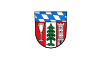
Coat of arms
The coat of arms displays:
- the blue and white checked pattern of Bavaria
- a glass, symbolising the glass industry
- a pine tree, symbolising the Bavarian Forest
- a tower, symbolising the castles in the district
Towns and municipalities

| Towns | Municipalities | |
|---|---|---|
References
- ^ Genesis Online-Datenbank des Bayerischen Landesamtes für Statistik Tabelle 12411-003r Fortschreibung des Bevölkerungsstandes: Gemeinden, Stichtag (Einwohnerzahlen auf Grundlage des Zensus 2011) (Hilfe dazu).
External links
Wikimedia Commons has media related to Landkreis Regen.
- Official website (German)
Towns and municipalities in Regen (district) | ||
|---|---|---|
 | ||
49°00′N 13°10′E / 49.0°N 13.17°E
| International | |
|---|---|
| National | |