
Amberg-Sulzbach | |
|---|---|
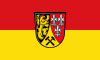 Flag  Coat of arms | |
 | |
| Country | Germany |
| State | Bavaria |
| Adm. region | Upper Palatinate |
| Founded | 1972-07-01 |
| Capital | Amberg |
| Government | |
| • District admin. | Richard Reisinger (CSU) |
| Area | |
| • Total | 1,255 km2 (485 sq mi) |
| Population (31 December 2022)[1] | |
| • Total | 104,436 |
| • Density | 83/km2 (220/sq mi) |
| Time zone | UTC+01:00 (CET) |
| • Summer (DST) | UTC+02:00 (CEST) |
| Vehicle registration | AS, BUL, ESB, NAB, SUL |
| Website | kreis-as.de |
Amberg-Sulzbach (Northern Bavarian: Amberg-Suizboch) is a Landkreis (district) in Bavaria, Germany. It surrounds but does not include the city of Amberg. It is bounded by (from the north and clockwise) the districts of Neustadt an der Waldnaab, Schwandorf, Neumarkt, Nürnberger Land and Bayreuth.
History
The history is linked with the history of the Upper Palatinate and the city of Amberg.
The district was established in 1972 by merging the former district of Amberg and the district-free city of Sulzbach-Rosenberg (the latter lost its status as a district-free city in this administrative reform).
Geography
The district is located in the geographical centre of Bavaria, 40 km east of Nuremberg. The main axis of the region is the Vils River (an affluent of the Naab) crossing the district from north to south. West of the river, the land rises to the Franconian Jura, while there are gentle hills on the eastern side in the angle between Naab and Vils. The district is mainly covered by forests, especially in its western half.
Coat of arms

The coat of arms displays:
- The Palatine Lion, which was the heraldic animal of the Upper Palatinate
- The lilies, which were a symbol of the counts of Sulzbach
- The mining tools are a reminder of the mining history of the Upper Palatinate
Towns and municipalities

| Towns | Municipalities | |
|---|---|---|
References
- ^ Genesis Online-Datenbank des Bayerischen Landesamtes für Statistik Tabelle 12411-003r Fortschreibung des Bevölkerungsstandes: Gemeinden, Stichtag (Einwohnerzahlen auf Grundlage des Zensus 2011) (Hilfe dazu).
External links
- Official website (German)
- Tourist information (German, French; English and Czech versions in process)
Towns and municipalities in Amberg-Sulzbach | ||
|---|---|---|
|  | |
49°30′N 11°45′E / 49.5°N 11.75°E
| International | |
|---|---|
| National | |