
Altötting | |
|---|---|
 Flag 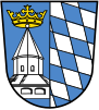 Coat of arms | |
 | |
| Country | Germany |
| State | Bavaria |
| Adm. region | Upper Bavaria |
| Capital | Altötting |
| Government | |
| • District admin. | Erwin Schneider (CSU) |
| Area | |
| • Total | 569.41 km2 (219.85 sq mi) |
| Population (31 December 2022)[1] | |
| • Total | 113,798 |
| • Density | 200/km2 (520/sq mi) |
| Time zone | UTC+01:00 (CET) |
| • Summer (DST) | UTC+02:00 (CEST) |
| Vehicle registration | AÖ, LF |
| Website | www |
Altötting (German pronunciation: [altˈʔœtɪŋ] ; Bavarian: Oidäding) is a Landkreis (district) in Bavaria, Germany. It is bounded by (from the east and clockwise) Austria and the Bavarian districts of Traunstein, Mühldorf and Rottal-Inn.
YouTube Encyclopedic
-
1/1Views:33 544
-
Castillos de Cuento: Alemania / Unique Castles From Germany [IGEO.TV]
Transcription
History
Altötting was one of the original parts of Bavaria. It was settled by Bavarian tribes shortly after the retreat of the Romans. During the rule of duke Tassilo III (748-788) the place of Ötting was mentioned for the first time (the towns of Altötting and Neuötting are derived from that place). Soon in the 9th century the region became a religious centre with famous churches and monasteries. In the 15th century it became a place of pilgrimage.
The district of Altötting was established in 1837. Pope Benedict XVI was born here 1927 in the village of Marktl.
The hearts of many of the rulers of Bavaria are buried in the Chapel of Grace in the middle of the town square.
Geography
The district is located in the alpine upland on the Austrian border. The main axis of the region is the river Inn, which crosses the district from west to east. It is joined by two large tributaries, the Alz coming from the south and the Salzach, which forms the eastern border of the district. In addition there are several smaller rivers and brooks. The district once was covered with deciduous forests, but is now mainly agriculturally used. However, there are some nature reserves along the lower Alz River and at the mouth of the Salzach River.
Coat of arms
The coat of arms displays:
- left: the pilgrimage Chapel of Grace in the town of Altötting
- right: the blue and white checked pattern of Bavaria
Towns and municipalities

| Towns | Municipalities | |
|---|---|---|
References
- ^ Genesis Online-Datenbank des Bayerischen Landesamtes für Statistik Tabelle 12411-003r Fortschreibung des Bevölkerungsstandes: Gemeinden, Stichtag (Einwohnerzahlen auf Grundlage des Zensus 2011) (Hilfe dazu).
External links
- Official website (German)
- Unofficial website (German)
Towns and municipalities in Altötting district | ||
|---|---|---|
 | ||
| International | |
|---|---|
| National | |
48°15′N 12°45′E / 48.25°N 12.75°E