
Kreis Eichstätt | |
|---|---|
 Flag  Coat of arms | |
 | |
| Country | Germany |
| State | Bavaria |
| Adm. region | Upper Bavaria |
| Capital | Eichstätt |
| Government | |
| • District admin. | Alexander Anetsberger (CSU) |
| Area | |
| • Total | 1,214 km2 (469 sq mi) |
| Population (31 December 2022)[1] | |
| • Total | 135,591 |
| • Density | 110/km2 (290/sq mi) |
| Time zone | UTC+01:00 (CET) |
| • Summer (DST) | UTC+02:00 (CEST) |
| Vehicle registration | EI |
| Website | landkreis-eichstaett.de |
Eichstätt is a Landkreis (district) in Bavaria, Germany. It is bounded by (from the south and clockwise) the districts of Neuburg-Schrobenhausen, Donau-Ries, Weißenburg-Gunzenhausen, Roth, Neumarkt, Kelheim and Pfaffenhofen, and by the city of Ingolstadt.
History
The district of Eichstätt in its present form was established in 1972 by merging the former district of Eichstätt with parts of the dissolved districts of Ingolstadt, Beilngries, Riedenburg and Hilpoltstein. The city of Eichstätt lost its status as a district-free city and became the capital of the new district. Today the Eichstätt district has powerful economic structures. The rate of jobless people is only 1.2% (June 2011).
Geography
The district is located in the southern part of the Frankish Alb. 80% of the district are situated in the Altmühltal Nature Park. In the southeast the Danube forms a short part of the border.
Coat of arms
The coat of arms displays:
- a torch, symbolising the industrial area within the metropolitan area of Ingolstadt
- a crosier, symbolising the bishopric of Eichstätt
- an antler, symbolising the medieval county of Hirschberg (German Hirsch = "deer")
- the blue and white checkered pattern of Bavaria
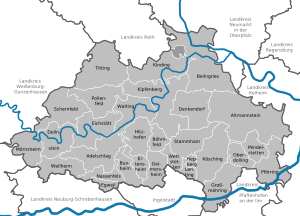
Towns and municipalities
| Towns | Municipalities | |
|---|---|---|
References
- ^ Genesis Online-Datenbank des Bayerischen Landesamtes für Statistik Tabelle 12411-003r Fortschreibung des Bevölkerungsstandes: Gemeinden, Stichtag (Einwohnerzahlen auf Grundlage des Zensus 2011)
External links
- Official website (German)
- Altmühltal Nature Park (German, English)
Towns and municipalities in Eichstätt (district) | ||
|---|---|---|
|  | |
48°55′N 11°20′E / 48.92°N 11.33°E
| International | |
|---|---|
| National | |