
Töging am Inn | |
|---|---|
 Town hall | |
 Coat of arms | |
Location of Töging am Inn within Altötting district 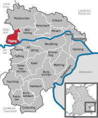 | |
 Töging am Inn  Töging am Inn | |
| Coordinates: 48°15′N 12°34′E / 48.250°N 12.567°E | |
| Country | Germany |
| State | Bavaria |
| Admin. region | Oberbayern |
| District | Altötting |
| Subdivisions | 9 Gemeindeteile |
| Government | |
| • Mayor (2020–26) | Tobias Windhorst[1] (CSU) |
| Area | |
| • Total | 13.66 km2 (5.27 sq mi) |
| Elevation | 398 m (1,306 ft) |
| Population (2022-12-31)[2] | |
| • Total | 9,465 |
| • Density | 690/km2 (1,800/sq mi) |
| Time zone | UTC+01:00 (CET) |
| • Summer (DST) | UTC+02:00 (CEST) |
| Postal codes | 84513 |
| Dialling codes | 08631 |
| Vehicle registration | AÖ |
| Website | www.toeging.de |
Töging am Inn (Central Bavarian: Deging am Inn) is a town of 9,382 inhabitants in the district of Altötting, Upper Bavaria, Germany. It lies on the river Inn.
YouTube Encyclopedic
-
1/3Views:4 9257 5991 229
-
A tribute to Harter Weg in Töging am Inn
-
100 Jahre Kraftwerksgeschichte: Töging am Inn
-
Töging a. Inn (AÖ), St. Josef, Vorläuten & Plenum
Transcription
History
Thanks to an artificial water canal, the town is adjacent to a large water power plant, which used to power e.g. an aluminum furnace. Because of many factories in the area, slave workers from the Dachau concentration camp were located nearby during World War II,.[3]
The town hit the news on 7 February 2006, when the roof of the local Netto supermarket collapsed. Nobody was hurt in the incident.[1]
References
- ^ Liste der ersten Bürgermeister/Oberbürgermeister in kreisangehörigen Gemeinden, Bayerisches Landesamt für Statistik, accessed 19 July 2021.
- ^ Genesis Online-Datenbank des Bayerischen Landesamtes für Statistik Tabelle 12411-003r Fortschreibung des Bevölkerungsstandes: Gemeinden, Stichtag (Einwohnerzahlen auf Grundlage des Zensus 2011)
- ^ Edward Victor.Alphabetical List of Camps, Subcamps and Other Camps.www.edwardvictor.com/Holocaust/List %20 of % 20 camps.htm
External links
- Official website
 (in German)
Towns and municipalities in Altötting district | ||
|---|---|---|
 | ||
| International | |
|---|---|
| National | |
| Geographic | |
This Altötting district location article is a stub. You can help Wikipedia by expanding it. |