
KML is from Wikidata
Wigan | |
|---|---|
 WN | |
| Coordinates: 53°32′02″N 2°38′13″W / 53.534°N 2.637°W | |
| Country | United Kingdom |
| Postcode area | WN |
| Postcode area name | Wigan |
| Post towns | 3 |
| Postcode districts | 8 |
| Postcode sectors | 35 |
| Postcodes (live) | 7,149 |
| Postcodes (total) | 9,152 |
| Statistics as at May 2020[1] | |
The WN postcode area, also known as the Wigan postcode area,[2] is a group of eight postcode districts in North West England, within three post towns. These cover most of the Metropolitan Borough of Wigan in Greater Manchester (including Wigan itself and Leigh), plus small parts of West Lancashire (including Skelmersdale) and the Metropolitan Borough of St Helens in Merseyside.
YouTube Encyclopedic
-
1/3Views:1 79877 4601 190
-
Postcodes in the United Kingdom
-
Ek Hindu Aap S A W Ki Mohabat Mein Jhoom Utha By Peace Tube
-
i won 3 crore rupees in lottery | this type of messages can cheat on your money in kannada|
Transcription
Coverage
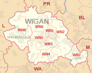
The approximate coverage of the postcode districts:
| Postcode district | Post town | Coverage | Local authority area(s) |
|---|---|---|---|
| WN1 | WIGAN | Haigh, Ince, Swinley, Wigan | Wigan |
| WN2 | WIGAN | Abram, Aspull, Bamfurlong, Bickershaw, Haigh, Hindley, Hindley Green, Ince, Platt Bridge | Wigan |
| WN3 | WIGAN | Goose Green, Ince, Winstanley, Worsley Mesnes, Hawkley Hall | Wigan |
| WN4 | WIGAN | Ashton-in-Makerfield, Garswood | Wigan, St Helens |
| WN5 | WIGAN | Billinge, Newtown, Higher End, Orrell, Pemberton, Winstanley, Worsley Hall, Marsh Green. | Wigan, St Helens |
| WN6 | WIGAN | Appley Bridge, Beech Hill, Shevington, Springfield, Standish, Wrightington | Wigan, West Lancashire |
| WN7 | LEIGH | Leigh, Hope Carr, Landside, Low Common, Bedford, Westleigh, Pennington, Higher Folds | Wigan |
| WN8 | WIGAN | Dalton, Newburgh, Parbold | West Lancashire |
| SKELMERSDALE | Chapel House, Holland Moor, Roby Mill, Skelmersdale, Up Holland |
Map
KML is from Wikidata
See also
References
- ^ "ONS Postcode Directory Version Notes" (ZIP). National Statistics Postcode Products. Office for National Statistics. May 2020. Table 2. Retrieved 19 June 2020. Coordinates from mean of unit postcode points, "Code-Point Open". OS OpenData. Ordnance Survey. February 2012. Retrieved 21 April 2012.
- ^ Royal Mail, Address Management Guide, (2004)