To install click the Add extension button. That's it.

The source code for the WIKI 2 extension is being checked by specialists of the Mozilla Foundation, Google, and Apple. You could also do it yourself at any point in time.

4,5
Kelly Slayton
Congratulations on this excellent venture… what a great idea!
Alexander Grigorievskiy
I use WIKI 2 every day and almost forgot how the original Wikipedia looks like.
Live Statistics
English Articles
Improved in 24 Hours
Added in 24 Hours
What we do. Every page goes through several hundred of perfecting techniques; in live mode. Quite the same Wikipedia. Just better.
.
Leo
Newton
Brights
Milds

DN postcode area

From Wikipedia, the free encyclopedia

KML is from Wikidata
Doncaster
DN is located in the United Kingdom
DN
DN
Coordinates: 53°32′31″N 0°43′30″W / 53.542°N 0.725°W / 53.542; -0.725
CountryUnited Kingdom
Postcode area
DN
Postcode area name
Doncaster
Post towns13
Postcode districts33
Postcode sectors117
Postcodes (live)21,700
Postcodes (total)27,780
Statistics as at May 2020[1]

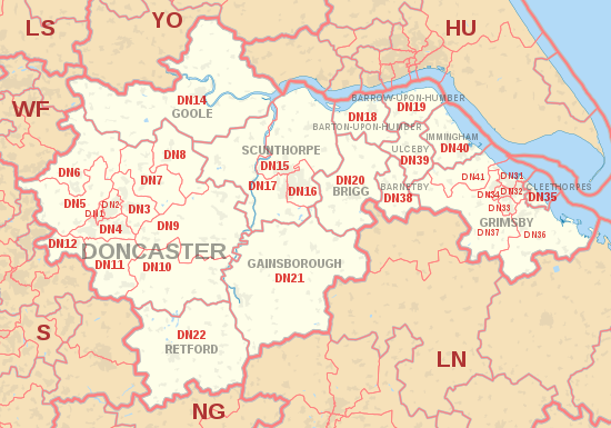
The DN postcode area, also known as the Doncaster postcode area,[2] is a group of 32 postcode districts in eastern England, within 13 post towns. These cover eastern South Yorkshire (including Doncaster), north Lincolnshire (including Grimsby, Scunthorpe, Barnetby, Barrow upon Humber, Barton-upon-Humber, Brigg, Cleethorpes, Gainsborough, Immingham and Ulceby), parts of north Nottinghamshire (including Retford) and the south-west of the East Riding of Yorkshire (including Goole), and a small part of southern North Yorkshire.

The S64 postcode district for Mexborough was earmarked as DN13, which has never been used. Otherwise, the area's districts are numbered sequentially up to DN22, then from DN31 to DN41 for Grimsby and surrounding settlements.

YouTube Encyclopedic

  • 1/1
    Views:
    444
  • Getting Started with Digimap for Schools - 19th and 20th September 2023

Transcription

Coverage

The approximate coverage of the postcode districts:

Postcode district Post town Coverage Local authority area(s)
DN1 DONCASTER Doncaster city centre, Hyde Park Doncaster
DN2 DONCASTER Intake, Wheatley, Wheatley Hills Doncaster
DN3 DONCASTER Armthorpe, Barnby Dun, Branton, Edenthorpe, Kirk Sandall Doncaster
DN4 DONCASTER Balby, Belle Vue, Bessacarr, Cantley, Hexthorpe, Warmsworth Doncaster
DN5 DONCASTER Arksey, Barnburgh, Bentley, Cadeby, Cusworth, Harlington, High Melton, Scawsby, Scawthorpe, Sprotbrough, Sunnyfields, Toll Bar Doncaster
DN6 DONCASTER Adwick-le-Street, Askern, Campsall, Carcroft, Fenwick, Moss, Norton, Sutton, Walden Stubbs, Womersley, Woodlands Doncaster, North Yorkshire
DN7 DONCASTER Dunsville, Dunscroft, Fishlake, Hatfield, Hatfield Woodhouse, Lindholme, Stainforth Doncaster
DN8 DONCASTER Moorends, Sandtoft, Thorne Doncaster, North Lincolnshire
DN9 DONCASTER Epworth, Finningley, Haxey, Auckley, Owston Ferry, Belton, Westwoodside, Wroot North Lincolnshire, Doncaster
DN10 DONCASTER Bawtry, Beckingham, Misson, Misterton, Scrooby Bassetlaw, Doncaster
DN11 DONCASTER Bircotes, Harworth, New Rossington, Rossington, Tickhill, Wadworth Doncaster, Bassetlaw
DN12 DONCASTER Conisbrough, Denaby Main, New Edlington, Old Denaby, Old Edlington Doncaster, Rotherham
DN14 GOOLE Goole, Carlton, Eggborough, Hensall, Howden, Pincheon Green, Pollington, Rawcliffe, Snaith, Sykehouse, Whitley, Whitley Bridge East Riding of Yorkshire, North Yorkshire, Doncaster
DN15 SCUNTHORPE Scunthorpe town centre, Alkborough, Appleby, Burton upon Stather, Coleby, Dragonby, Flixborough, Flixborough Ind Estate, Foxhills Ind Estate, Frodingham, Gunness, High Risby, High Santon, Low Risby, Low Santon, Normanby, Roxby, Thealby, West Halton, Whitton, Winteringham, Winterton North Lincolnshire
DN16 SCUNTHORPE Bottesford, Holme, Queensway Ind Estate, New Brumby, Old Brumby, Raventhorpe & Twigmoor North Lincolnshire
DN17 SCUNTHORPE Althorpe, Amcotts, Bottesford Moor, Bottesford, Crowle, Derrythorpe, Ealand, East Butterwick, Eastoft, Garthorpe, Gunness, Keadby, Luddington, Messingham, North Ewster, Susworth, West Butterwick, Yaddlethorpe North Lincolnshire
DN18 BARTON-UPON-HUMBER Barton-upon-Humber, South Ferriby, Horkstow North Lincolnshire
DN19 BARROW-UPON-HUMBER Barrow-upon-Humber, Goxhill, New Holland North Lincolnshire
DN20 BRIGG Brigg, Broughton, Hibaldstow, Scawby, Wrawby North Lincolnshire
DN21 GAINSBOROUGH Gainsborough, Kirton Lindsey, Marton, Lea, Blyton, Scotter, Scotton West Lindsey
DN22 RETFORD Retford, Ranskill Bassetlaw
DN31 GRIMSBY Grimsby town centre North East Lincolnshire
DN32 GRIMSBY Old Clee North East Lincolnshire
DN33 GRIMSBY Nunsthorpe, Scartho, Scartho Top North East Lincolnshire
DN34 GRIMSBY Laceby Acres, Little Coates North East Lincolnshire
DN35 CLEETHORPES Cleethorpes North East Lincolnshire
DN36 GRIMSBY Holton-le-Clay, Humberston, Ludborough, Marshchapel, New Waltham, North Cotes, North Thoresby, Tetney East Lindsey, North East Lincolnshire
DN37 GRIMSBY Ashby cum Fenby, Barnoldby-le-Beck, Beelsby, Bradley, Brocklesby, Great Coates, Great Limber, Irby-upon-Humber, Laceby, Waltham North East Lincolnshire, West Lindsey
DN38 BARNETBY Barnetby le Wold, Grasby, Searby, Somerby North Lincolnshire, West Lindsey
DN39 ULCEBY Ulceby, Croxton, Kirmington, Wootton North Lincolnshire
DN40 IMMINGHAM Immingham, North Killingholme, South Killingholme, Habrough, East Halton North Lincolnshire, North East Lincolnshire
DN41 GRIMSBY Healing, Keelby, Stallingborough North East Lincolnshire, West Lindsey
DN55 DONCASTER Royal Mail Physical-to-Electronic Centre (PTE),[3][4] Royal Mail Returns Management Service[5] non-geographic

Map

KML is from Wikidata
DN postcode area map, showing postcode districts, post towns and neighbouring postcode areas.
HU postcode areaLN postcode areaLS postcode areaLS postcode areaNG postcode areaPE postcode areaS postcode areaWF postcode areaYO postcode area
DN postcode area map, showing postcode districts in red and post towns in grey text, with links to nearby HU, LN, LS, NG, S, WF and YO postcode areas.

See also

References

  1. ^ "ONS Postcode Directory Version Notes" (ZIP). National Statistics Postcode Products. Office for National Statistics. May 2020. Table 2. Retrieved 19 June 2020. Coordinates from mean of unit postcode points, "Code-Point Open". OS OpenData. Ordnance Survey. February 2012. Retrieved 21 April 2012.
  2. ^ Royal Mail, Address Management Guide, (2004)
  3. ^ Linda, Rosencrance (1 June 2000). "UK Postal Service Launches Online Mail Service". Computerworld Australia. IDG Communications. Retrieved 4 February 2012.
  4. ^ Royal Mail (18 July 2011). "Non-geographic codes" (PDF). p. 2. Archived from the original (PDF) on 20 January 2012. Retrieved 4 February 2012.
  5. ^ "A guide for letter envelope design and clear addressing" (PDF). London: Royal Mail Group Ltd. 26 November 2019. p. 37. Retrieved 11 April 2022.

External links

This page was last edited on 25 March 2024, at 18:52
Basis of this page is in Wikipedia. Text is available under the CC BY-SA 3.0 Unported License. Non-text media are available under their specified licenses. Wikipedia® is a registered trademark of the Wikimedia Foundation, Inc. WIKI 2 is an independent company and has no affiliation with Wikimedia Foundation.