To install click the Add extension button. That's it.

The source code for the WIKI 2 extension is being checked by specialists of the Mozilla Foundation, Google, and Apple. You could also do it yourself at any point in time.

4,5
Kelly Slayton
Congratulations on this excellent venture… what a great idea!
Alexander Grigorievskiy
I use WIKI 2 every day and almost forgot how the original Wikipedia looks like.
Live Statistics
English Articles
Improved in 24 Hours
Added in 24 Hours
What we do. Every page goes through several hundred of perfecting techniques; in live mode. Quite the same Wikipedia. Just better.
.
Leo
Newton
Brights
Milds

HG postcode area

From Wikipedia, the free encyclopedia

KML is from Wikidata
Harrogate
HG is located in the United Kingdom
HG
HG
Coordinates: 54°02′31″N 1°33′07″W / 54.042°N 1.552°W / 54.042; -1.552
CountryUnited Kingdom
Postcode area
HG
Postcode area name
Harrogate
Post towns3
Postcode districts5
Postcode sectors25
Postcodes (live)4,409
Postcodes (total)6,317
Statistics as at May 2020[1]

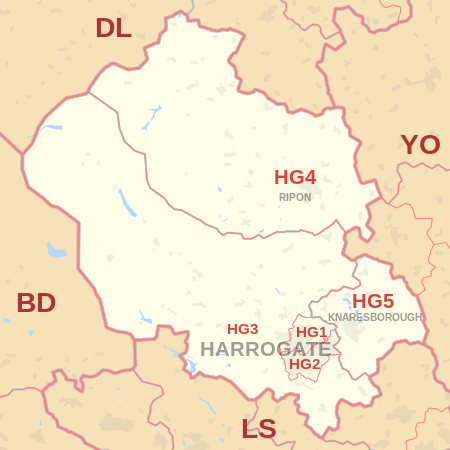
The HG postcode area, also known as the Harrogate postcode area,[2] is a group of five postcode districts in England, within three post towns. These postcode districts cover Harrogate, Ripon and Knaresborough in North Yorkshire.

HG1 and HG2 cover most of the urban area of Harrogate. HG1 covers areas north of The Stray including the town centre, while HG2 covers areas to the south and west of The Stray. East of The Stray, HG1 generally covers areas to the north of the A59 Knaresborough Road, while HG2 covers areas to the south. HG3 spans across some of the town's westernmost suburbs, some settlements immediately to the south, as well as a large rural area to the north and west. HG4 covers Ripon and some surrounding settlements and rural areas. HG5 covers Knaresborough and some rural areas to the north and east.

It is the only postcode area located entirely within North Yorkshire, and when ranked by number of postcode districts it is the second smallest postcode area in the United Kingdom, behind only the ZE postcode area which has three districts. However, many postcode areas with a greater number of districts cover fewer square miles in total.

YouTube Encyclopedic

  • 1/2
    Views:
    1 170
    307 435
  • Postcodes in the United Kingdom
  • شرح طريقة فتح حساب مجاني في الاب ستور | Apple Store

Transcription

Coverage

The approximate coverage of the postcode districts:

Postcode district Post town Coverage Local authority area(s)
HG1 HARROGATE Central, Bilton, High Harrogate, Jennyfields, Duchy, New Park North Yorkshire
HG2 HARROGATE Oatlands, Woodlands, Hookstone, Rossett, Pannal Ash, Harlow Hill, Low Harrogate, Hornbeam Park North Yorkshire
HG3 HARROGATE Jennyfields, Pannal, Burn Bridge, Kirkby Overblow, Killinghall, Greenhow, Fewston, Beckwithshaw, Spofforth, Bishop Monkton, Bishop Thornton, Glasshouses, Follifoot, Pateley Bridge, Summerbridge, Ripley, Brearton, Burton Leonard, Netherby, Hampsthwaite, Nidd, South Stainley, Wormald Green, Markington, Burnt Yates, Bedlam, Shaw Mills, Birstwith, Warsill, Darley, Dacre, Wath-in-Nidderdale, Middlesmoor, Lofthouse, Ramsgill, Stean, Bewerley, Thornthwaite, Thruscross, West End North Yorkshire
HG4 RIPON Ripon, North Stainley, High Grantley, Masham, West Tanfield, Thornton Watlass, Thornton Steward, Sawley, Eavestone, Littlethorpe, Skelton-on-Ure, Marton-le-Moor, North Stainley, Wath, Nunwick, Melmerby, Middleton Quernhow, Bridge Hewick, Sharow, Copt Hewick, Hutton Conyers, Aldfield, Kirkby Malzeard, Leighton, Colsterdale, Gollinglith Foot, Azerley, Galphay, Winksley, Sutton Grange, Grewelthorpe, Rookwith, Low Ellington, Thirn North Yorkshire
HG5 KNARESBOROUGH Knaresborough, Scotton, Goldsborough, Arkendale, Allerton Mauleverer, Hopperton, Flaxby, Coneythorpe, Staveley, Ferrensby, Farnham, Calcutt, Plompton North Yorkshire

Map

KML is from Wikidata
HG postcode area map, showing postcode districts, post towns and neighbouring postcode areas.
BD postcode areaDL postcode areaLS postcode areaYO postcode areaYO postcode area
HG postcode area map, showing postcode districts in red and post towns in grey text, with links to nearby BD, DL, LS and YO postcode areas.

See also

References

  1. ^ "ONS Postcode Directory Version Notes" (ZIP). National Statistics Postcode Products. Office for National Statistics. May 2020. Table 2. Retrieved 19 June 2020. Coordinates from mean of unit postcode points, "Code-Point Open". OS OpenData. Ordnance Survey. February 2012. Retrieved 21 April 2012.
  2. ^ Royal Mail, Address Management Guide, (2004)

External links

This page was last edited on 1 March 2024, at 21:11
Basis of this page is in Wikipedia. Text is available under the CC BY-SA 3.0 Unported License. Non-text media are available under their specified licenses. Wikipedia® is a registered trademark of the Wikimedia Foundation, Inc. WIKI 2 is an independent company and has no affiliation with Wikimedia Foundation.