
Tavşanlı District | |
|---|---|
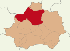 Map showing Tavşanlı District in Kütahya Province | |
 Tavşanlı District Location in Turkey  Tavşanlı District Tavşanlı District (Turkey Aegean) | |
| Coordinates: 39°32′N 29°29′E / 39.533°N 29.483°E | |
| Country | Turkey |
| Province | Kütahya |
| Seat | Tavşanlı |
| Government | |
| • Kaymakam | Hayrettin Baskın |
| Area | 1,899 km2 (733 sq mi) |
| Population (2022) | 100,568 |
| • Density | 53/km2 (140/sq mi) |
| Time zone | UTC+3 (TRT) |
| Website | www |
Tavşanlı District is a district of the Kütahya Province of Turkey. Its seat is the city of Tavşanlı.[1] Its area is 1,899 km2,[2] and its population is 100,568 (2022).[3]
Composition
There are five municipalities in Tavşanlı District:[1][4]
There are 87 villages in Tavşanlı District:[5]
- Ağaköy
- Akçaköy
- Akçaşehir
- Aliköy
- Altınova
- Arifler
- Artıranlar
- Avcılar
- Aydınlar
- Ayvalı
- Başköy
- Bozbelen
- Burhan
- Çakıllı
- Çaldibi
- Çaltılı
- Çamalan
- Çayırköy
- Çayıroluk
- Çıkrıcak
- Çınarcık
- Çobanköy
- Çobanlar
- Dağdemirli
- Değirmisaz
- Derbent
- Derecik
- Devekayası
- Doğanlar
- Dudaş
- Dümrekhüseyinpaşa
- Dümrekorta
- Dümrekuluköy
- Dutlar
- Eğriöz
- Elmaağacı
- Elmalı
- Emirler
- Erikli
- Eşen
- Gazelyakup
- Gevrekler
- Göbel
- Gökçeyurt
- Gölcük
- Gümüşgölcük
- Gümüşyeniköy
- İsaköy
- Karacakaş
- Karakaya
- Karakişi
- Karaköy
- Karapelit
- Karcık
- Kargılı
- Karlı
- Kavaklı
- Kayaarası
- Kayı
- Kırkkavak
- Kışlademirli
- Kızılbük
- Kızılçukur
- Kocayeri
- Köprücek
- Köreken
- Köseler
- Kozluca
- Madanlar
- Nusretler
- Öksüzler
- Opanözü
- Ören
- Ovacık
- Şahin
- Şahmelek
- Şapçı
- Şapçıdede
- Sekbandemirli
- Şenlik
- Uluçam
- Üyücek
- Vakıf
- Yağmurlu
- Yataklı
- Yeniköy
- Yörgüç
References
- ^ a b İlçe Belediyesi, Turkey Civil Administration Departments Inventory. Retrieved 22 May 2023.
- ^ "İl ve İlçe Yüz ölçümleri". General Directorate of Mapping. Retrieved 22 May 2023.
- ^ "Address-based population registration system (ADNKS) results dated 31 December 2022, Favorite Reports" (XLS). TÜİK. Retrieved 22 May 2023.
- ^ Belde Belediyesi, Turkey Civil Administration Departments Inventory. Retrieved 22 May 2023.
- ^ Köy, Turkey Civil Administration Departments Inventory. Retrieved 22 May 2023.
Tavşanlı District in Kütahya Province of Turkey | |||||||||||||||||||||||||||
|---|---|---|---|---|---|---|---|---|---|---|---|---|---|---|---|---|---|---|---|---|---|---|---|---|---|---|---|
| Districts |  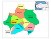 | ||||||||||||||||||||||||||
|
Metropolitan municipalities are bolded. | |||||||||||||||||||||||||||
| Municipalities | |
|---|---|
| Villages |
|
This article about an Aegean Region of Turkey location is a stub. You can help Wikipedia by expanding it. |