
Bursa Province
Bursa ili | |
|---|---|
 Pine trees seen from Uludağ Road | |
 Location of the province within Turkey | |
| Country | Turkey |
| Seat | Bursa |
| Government | |
| • Mayor | Mustafa Bozbey (CHP) |
| • Vali | Mahmut Demirtaş |
| Area | 10,813 km2 (4,175 sq mi) |
| Population (2022)[1] | 3,194,720 |
| • Density | 300/km2 (770/sq mi) |
| Time zone | UTC+3 (TRT) |
| Area code | 0224 |
| Website | www www |
Bursa Province (Turkish: Bursa ili) is a province and metropolitan municipality in Turkey along the Sea of Marmara coast in northwestern Anatolia. It borders Balıkesir to the west, Kütahya to the south, Bilecik and Sakarya to the east, Kocaeli to the northeast and Yalova to the north. Its area is 10,813 km2,[2] and its population is 3,194,720 (2022).[1] Its traffic code is 16.
Almost all of Bursa Province (including the city of Bursa) is in the Marmara Region, but the districts of Büyükorhan, Harmancık, Keles and Orhaneli are in the Aegean Region.
The city of Bursa was the capital of the Ottoman State between 1326 and 1365, until the Ottoman conquest of Edirne, then known as Adrianople. Adrianople was the capital until 1453, when Constantinople became the final Ottoman capital.
YouTube Encyclopedic
-
1/5Views:2 0151 6092 6807 9371 249
-
bursaturkey city tour|bursa turkey tour|bursaspor|bursa
-
Iznik City Center Tour | Bursa
-
Bursa, the green and beautiful city! | New vlog!
-
Bursa Turkey Winter 2019 | Travel Log
-
Bursa Walking Tour - Turkey 🇹🇷 [4k 60fps] Ulu Cami, Kapalı Çarşı
Transcription
Geography
![Köppen map of Bursa Province and surrounding regions:[3] .mw-parser-output figure[typeof="mw:File/Thumb"] .image-key>ol{margin-left:1.3em;margin-top:0}.mw-parser-output figure[typeof="mw:File/Thumb"] .image-key>ul{margin-top:0}.mw-parser-output figure[typeof="mw:File/Thumb"] .image-key li{page-break-inside:avoid;break-inside:avoid-column}@media(min-width:300px){.mw-parser-output figure[typeof="mw:File/Thumb"] .image-key,.mw-parser-output figure[typeof="mw:File/Thumb"] .image-key-wide{column-count:2}.mw-parser-output figure[typeof="mw:File/Thumb"] .image-key-narrow{column-count:1}}@media(min-width:450px){.mw-parser-output figure[typeof="mw:File/Thumb"] .image-key-wide{column-count:3}}.mw-parser-output .plainlist ol,.mw-parser-output .plainlist ul{line-height:inherit;list-style:none;margin:0;padding:0}.mw-parser-output .plainlist ol li,.mw-parser-output .plainlist ul li{margin-bottom:0}.mw-parser-output .legend{page-break-inside:avoid;break-inside:avoid-column}.mw-parser-output .legend-color{display:inline-block;min-width:1.25em;height:1.25em;line-height:1.25;margin:1px 0;text-align:center;border:1px solid black;background-color:transparent;color:black}.mw-parser-output .legend-text{} BSk Csa Csb Cfa Dsb Dsc](http://upload.wikimedia.org/wikipedia/commons/c/c0/Koppen-Geiger_Map_TUR_present_with_provinces.svg)
Bursa mostly experiences a Mediterranean climate (Csa and Csb). Inner parts of the province are higher in elevation and show continental characteristics (Dsb and Dsc). Uludağ is the highest mountain in the province with 2,543 meters of elevation.
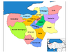
Districts


Demographics
| Year | Pop. | ±% p.a. |
|---|---|---|
| 1927 | 401,595 | — |
| 1940 | 461,648 | +1.08% |
| 1950 | 545,919 | +1.69% |
| 1960 | 693,894 | +2.43% |
| 1970 | 847,884 | +2.02% |
| 1980 | 1,148,492 | +3.08% |
| 1990 | 1,603,137 | +3.39% |
| 2000 | 2,125,140 | +2.86% |
| 2010 | 2,605,495 | +2.06% |
| 2018 | 2,994,521 | +1.75% |
| 2024 | 2,116,000 1.44% | — |
| source:[4][5] | ||
See also
References
- ^ a b "Address-based population registration system (ADNKS) results dated 31 December 2022, Favorite Reports" (XLS). TÜİK. Retrieved 19 September 2023.
- ^ "İl ve İlçe Yüz ölçümleri". General Directorate of Mapping. Retrieved 19 September 2023.
- ^ "Present and future Köppen-Geiger climate classification maps at 1-km resolution". Nature Scientific Data. DOI:10.1038/sdata.2018.214.
- ^ Genel Nüfus Sayımları
- ^ tuik
External links

| National | |
|---|---|
| Geographic | |
| Other | |
40°09′00″N 29°01′15″E / 40.15000°N 29.02083°E