
Tupac Amaru
Tupaq Amaru | |
|---|---|
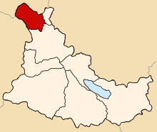 Location of Tupac Amaru in the Canas province | |
| Country | |
| Region | Cusco |
| Province | Canas |
| Founded | September 1, 1941 |
| Capital | Tungasuca |
| Government | |
| • Mayor | Honorato Ttito Quispe (2007) |
| Area | |
| • Total | 117.81 km2 (45.49 sq mi) |
| Elevation | 3,791 m (12,438 ft) |
| Population | |
| • Total | 3,423 |
| • Density | 29/km2 (75/sq mi) |
| Time zone | UTC-5 (PET) |
| UBIGEO | 080508 |
Tupac Amaru District is one of eight districts in the Canas Province in Peru. Its seat is the village of Tungasuca.
YouTube Encyclopedic
-
1/3Views:1 3949883 695
-
Mural Colegio Tupac Amaru
-
Pasacalle Colegio Tupac Amaru 3055 - Comas - 2014
-
Colegio Túpac Amaru .Desfile 2 de mayo 2015
Transcription
Geography
One of the highest peaks of the district is Puka Kancha at approximately 4,400 m (14,400 ft). Other mountains are listed below:[1]
- Anka Suka
- Ayna
- Hatun Ñan
- Pukara
- Suka
- Tunka Suka
- Wanu Kunka
Ethnic groups
The people in the district are mainly indigenous citizens of Quechua descent. Quechua is the language which the majority of the population (97.85%) learnt to speak in childhood, 1.72% of the residents started speaking using the Spanish language (2007 Peru Census).[2]
Sources
- ^ escale.minedu.gob.pe/ UGEL map Canas Province (Cusco Region)
- ^ inei.gob.pe Archived 2013-01-27 at the Wayback Machine INEI, Peru, Censos Nacionales 2007, Frequencias: Preguntas de Población
| |
|---|---|
| Acomayo | |
| Anta | |
| Calca | |
| Canas | |
| Canchis | |
| Chumbivilcas | |
| Cusco | |
| Espinar | |
| La Convención | |
| Paruro | |
| Paucartambo | |
| Quispicanchi | |
| Urubamba | |
This Cusco Region geography article is a stub. You can help Wikipedia by expanding it. |
14°09′25″S 71°30′18″W / 14.1570°S 71.5049°W