
Layo
Layu | |
|---|---|
![The train the Belmond Andean Explorer[1] at La Raya Station with market stalls and the mountain Chimpulla in the background, Layo District-Santa Rosa District](/wikipedia/commons/thumb/a/a9/Vista_Panor%C3%A1mica_del_distrito_de_Layo.jpg/250px-Vista_Panor%C3%A1mica_del_distrito_de_Layo.jpg) The train the Belmond Andean Explorer[1] at La Raya Station with market stalls and the mountain Chimpulla in the background, Layo District-Santa Rosa District | |
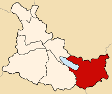 Location of Layo in the Canas province | |
| Country | |
| Region | Cusco |
| Province | Canas |
| Founded | January 2, 1857 |
| Capital | Layo |
| Government | |
| • Mayor | Daniel Praxides Quispe Alanocca (2007) |
| Area | |
| • Total | 452.56 km2 (174.73 sq mi) |
| Elevation | 3,978 m (13,051 ft) |
| Population | |
| • Total | 6,822 |
| • Density | 15/km2 (39/sq mi) |
| Time zone | UTC-5 (PET) |
| UBIGEO | 080505 |
Layo District is one of eight districts in the Canas Province in Peru. The seat of the Layo District is the village Layo.
Geography
The La Raya mountain range traverses the district. Some of the highest mountains of the district are listed below:[2]
- Anta
- Anta Pata
- Aqu Muqu
- Chayña Tira
- Chawpi Tira
- Chimpulla
- Ch'ulluni
- Hatun Ichhuna Kunka
- Huch'uy K'uchu
- Jichu Qullu
- Kancha
- Kimsa Urqu
- Kiswarani
- Kunka
- Kuntur Sallana
- Laramani
- Pawka
- Pichaqani
- Pinqulluni
- Puka Puka
- Puka Urqu
- Pukara
- Phawsi Urqu
- Qayqu
- Q'atawi
- Sapan Warmi
- Saywani
- Suntur Qullu
- Sura Quta
- Tika Pallana
- Waylla Kunka
- Yana Ranra
Ethnic groups
The people in the district are mainly indigenous citizens of Quechua descent. Quechua is the language which the majority of the population (90.47%) learnt to speak in childhood, 9.39% of the residents started speaking using the Spanish language (2007 Peru Census).[3]
Sources
- ^ Belmont
- ^ escale.minedu.gob.pe - UGEL map of the Melgar Province (Puno Region)
- ^ inei.gob.pe Archived 2013-01-27 at the Wayback Machine INEI, Peru, Censos Nacionales 2007, Frequencias: Preguntas de Población
| |
|---|---|
| Acomayo | |
| Anta | |
| Calca | |
| Canas | |
| Canchis | |
| Chumbivilcas | |
| Cusco | |
| Espinar | |
| La Convención | |
| Paruro | |
| Paucartambo | |
| Quispicanchi | |
| Urubamba | |
This Cusco Region geography article is a stub. You can help Wikipedia by expanding it. |
14°30′19″S 71°13′31″W / 14.5054°S 71.2253°W