
Brazil is divided into several types and levels of subdivisions.
YouTube Encyclopedic
-
1/5Views:993 87414 7307 168161 554292 441
-
The states of Brazil explained (Geography Now!)
-
How to Draw a Mapchart in Excel with your data?
-
Richest Country Subdivisions by GDP (PPP) 2019
-
Japan's Weirdly Out Of Place Region Name
-
Flags with Maps - Part 1
Transcription
Regions
Since 1942, the Brazilian Institute of Geography and Statistics has divided Brazil into five geographic regions.[1] On 23 November 1970, the regions of Brazil were adjusted slightly to the definition that is still in use today.[2] The division into regions is merely academic and statistical, as the regions do not enjoy any political autonomy.
- North Region (Região Norte)
- Northeast Region (Região Nordeste)
- Central-West Region (Região Centro-Oeste)
- Southeast Region (Região Sudeste)
- South Region (Região Sul)
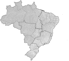
Federative units
Brazil is divided into 27 federative units: 26 states and 1 federal district (Distrito Federal).
 Acre (AC)
 Alagoas (AL)
 Amapá (AP)
 Amazonas (AM)
 Bahia (BA)
 Ceará (CE)
 Espírito Santo (ES)
 Goiás (GO)
 Maranhão (MA)
 Mato Grosso (MT)
 Mato Grosso do Sul (MS)
 Minas Gerais (MG)
 Pará (PA)
 Paraíba (PB)
 Paraná (PR)
 Pernambuco (PE)
 Piauí (PI)
 Rio de Janeiro (RJ)
 Rio Grande do Norte (RN)
 Rio Grande do Sul (RS)
 Rondônia (RO)
 Roraima (RR)
 Santa Catarina (SC)
 São Paulo (SP)
 Sergipe (SE)
 Tocantins (TO)
 Distrito Federal (DF)
Municipalities
The lowest level of political division of Brazil are the municipalities, which also enjoy political and economical autonomy. There are over 5500 municipalities in Brazil, comprising almost the entirety of the country's territory. The only exceptions are the Federal District (not divided into municipalities, but into 33 administrative regions, without any political autonomy) and the archipelago of Fernando de Noronha, which consists in a state district.
Statistical Areas
For statistical purposes, Brazilian states and the Federal District are divided into "Intermediate Geographic Regions" (Portuguese: Regiões Geográficas Intermediárias), which themselves are divided into smaller "Immediate Geographic Regions" (Regiões Geográficas Imediatas) which correspond to a metropolitan area.[3] From 1989-2017, they were grouped into mesoregions and microregions.
See also
- ISO 3166-2:BR
- Proposed states and territories of Brazil
- Former subdivisions of Brazil
- Indigenous territories
References
- ^ "Divisão Regional". ibge.gov.br (in Portuguese). Instituto Brasileiro de Geografia e Estatística. Retrieved 15 November 2015.
- ^ Contel, Fabio Betioli. "As divisões regionais do IBGE no século XX (1942, 1970 e 1990)". terrabrasilis.revues.org (in Portuguese). Terra Brasilis: Revista da Rede Brasileira de História da Geografia e Geografia Histórica. doi:10.4000/terrabrasilis.990. Retrieved 15 November 2015.
- ^ "Divisão Regional do Brasil | IBGE". www.ibge.gov.br. Retrieved 2021-03-21.
Subdivisions of the Americas | ||
|---|---|---|
| ||
|  | |
| Sovereign states |
| |
| ||