

A salient, panhandle, or bootheel is an elongated protrusion of a geopolitical entity, such as a subnational entity or a sovereign state.
While similar to a peninsula in shape, a salient is most often not surrounded by water on three sides. Instead, it has a land border on at least two sides and extends from the larger geographical body of the administrative unit.
In American English, the term panhandle is often used to describe a relatively long and narrow salient, such as the westernmost extensions of Florida and Oklahoma, or the northernmost portion of Idaho. Another term is bootheel, used for the Missouri Bootheel and New Mexico Bootheel areas.
YouTube Encyclopedic
-
1/3Views:9 5183 24738 815
-
Salient features of World’s Physical Geography | 60 Days Free Mains Answer Writing | OnlyIAS
-
How did Connecticut get its Panhandle?
-
SoFTNET T-SAT Presents || TSPSC - ఫారెస్ట్ ఉద్యోగాలు - అవగాహన కార్యక్రమం || Live With Experts
Transcription
Origin
The term salient is derived from military salients. The term "panhandle" derives from the analogous part of a cooking pan, and its use is generally confined to North America.
The salient shape can be the result of arbitrarily drawn international or subnational boundaries, though the location of administrative borders can also take into account other considerations such as economic ties or topography.
Country-level salients
Africa
- Cibitoke Province, Burundi
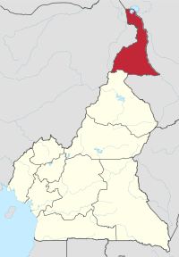
- Far North Region, Cameroon
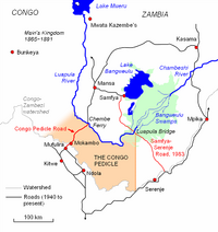
- Congo Pedicle, Democratic Republic of the Congo
- Kongo Central, Democratic Republic of the Congo
- Southern Red Sea Region, Eritrea
- Gambela Region, Ethiopia
- Somali Region, Ethiopia
- Nimba County, Liberia
- Nsanje District, Malawi
- Kayes Region, Mali
- Azawad, Mali
- Tete Province, Mozambique
- Caprivi Strip, Namibia
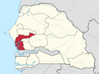
- Casamance, Senegal
- Kalahari Gemsbok National Park, South Africa
- Upper Nile, South Sudan
- Blue Nile, Sudan
- Wadi Halfa Salient, Sudan
- Kagera Region, Tanzania
- Cinkassé Prefecture, Togo
Americas
- Misiones, Argentina
- Southern Ontario (particularly Ontario Peninsula), Canada
- Tatshenshini-Alsek Park, British Columbia, Canada
- Madawaska County, New Brunswick, Canada
- Leticia Trapeze, Colombia
- Southeast Guainía Department, Colombia
- Yavaraté, Vaupés Department, Colombia
- Petén Department, Guatemala
- Tumbes Region, Peru
- Southeast Alaska, Alaska, United States (see also Panhandles in the United States)
- Amazonas, Venezuela
Asia


- Wakhan Corridor, Afghanistan
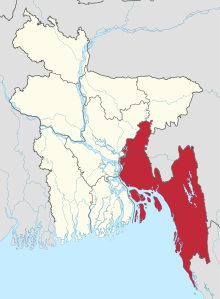
- Chittagong, Bangladesh
- Rangpur, Bangladesh
- Western Belait District, Brunei
- Tanintharyi Region, Burma (Myanmar)
- Parrot's Beak, Cambodia
- Yadong County (Tibet Autonomous Region), China
- Seven Sister States, India (largest in the world)
- Sikkim, India
- Jerusalem corridor, Israel
- Galilee panhandle, Israel
- Mafraq Governorate, Jordan
- Mangystau Region, Kazakhstan
- Batken, Kyrgyzstan
- Phongsaly Province, Laos
- Tfail Salient, Lebanon
- North Hamgyŏng, South Hamgyŏng, and Ryanggang, North Korea[citation needed][who?]
- Primorsky Krai, Russia
- Sughd, Tajikistan
- Southern Thailand, Thailand
- Aralık, Iğdır Province, Turkey
- Hatay Province, Turkey
- Jizzakh Region, Sirdaryo Region, Tashkent Region, Tashkent City, Namangan, Fergana and Andijan Regions, Uzbekistan
- Surxondaryo Region, Uzbekistan
- Tây Ninh Province, Vietnam
Europe

- Syunik, Armenia
- Tyrol and Vorarlberg, Austria
- West Flanders, Belgium
- Neum, Bosnia and Herzegovina
- Dubrovnik-Neretva County, Croatia
- Ilok, Croatia
- Louroujina Salient, Cyprus
- Cheb District, Czech Republic
- Šluknov Hook, Czech Republic
- Laatre, Viljandi County, Estonia
- Enontekiö, Finland
- Charleville-Mézières, France
- Kakheti, Georgia
- Western Thrace, Greece
- County Donegal, Ireland
- County Monaghan, Ireland
- Province of Trieste, Italy
- Dieveniškės appendix, Lithuania
- Castelré, North Brabant, the Netherlands
- Limburg, the Netherlands
- County Fermanagh, United Kingdom
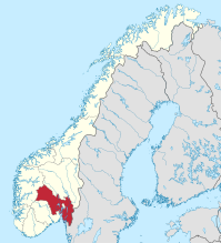
- Pasvikdalen valley, Norway
- Bogatynia, Poland
- Melgaço and north of Monção and Arcos de Valdevez (Viana do Castelo District), Portugal
- Tourém in north of Montalegre (Vila Real District), Portugal
- Couto Misto in north of Montalegre (Vila Real District), Portugal
- Miranda do Douro, Mogadouro and Vimioso (Bragança District), Portugal
- Moura and eastern Barrancos (Beja District) and Mourão (Évora District), Portugal
- Olivenza claim of Portugal in Spain
- Bryansk Oblast, Russia
- Ain, France (around the border of Switzerland)
- Galicia, Spain
- Canton of Geneva, Switzerland
- Canton of Schaffhausen, Switzerland
- Bernina, Inn, Lugano, Mendrisio and Porrentruy Districts, Switzerland
- Budjak, Ukraine
- Jamena, Serbia
- Petsamo, formerly Finland
Subnational salients
The following locations are salients in First-level administrative subdivisions of nations.
Subnational salients in Africa

- Tafraoui, Oran Province, Algeria
- Southwestern Saïda Province, Algeria
- Northeastern Bié Province, Angola
- Eastern Kgalagadi District, Botswana
- Balé Province, Boucle du Mouhoun Region, Burkina Faso
- Kouritenga Province, Centre-Est Region, Burkina Faso
- Northwest Bujumbura Rural Province, Burundi
- Northern Muyinga Province, Burundi
- Kimongo District, Niari Department, Republic of the Congo
- Northwestern Wele-Nzas Province, Equatorial Guinea
- Sitti Zone, Somali Region, Ethiopia
- Haut-Komo Department, Woleu-Ntem Province, Gabon
- Upper Denkyira West District, Central Region, Ghana
- Télimélé Prefecture, Kindia Region, Guinea
- Northeast Mamou Prefecture, Mamou Region, Guinea
- Western Isiolo County, Kenya
- Eastern Al Wahat District, Libya
- Southern Mzimba District, Northern Region, Malawi
- Eastern Dakhlet Nouadhibou Region, Mauritania
- Boumdeid Department, Assaba Region, Mauritania
- Southeastern Tete Province, Mozambique
- Gossas Department, Fatick Region, Senegal
- Southern Uvinza District, Kigoma Region, Tanzania
- Babati, Hanang, and Mbulu Districts, Manyara Region, Tanzania
- Gokwe North and Gokwe South Districts, Midlands Province, Zimbabwe
Subnational salients in the Americas

- Southern Buenos Aires Province, Argentina
- Luis Calvo, Chuquisaca Department, Bolivia
- Sud Cinti, Chuquisaca Department, Bolivia
- Whale Coast, Bahia, Brazil
- Alto Parnaíba, Balsas, and Tasso Fragoso, southernmost Maranhão, Brazil
- Northern Mato Grosso, Brazil
- Ponta do Abunã in northwest Rondônia, Brazil
- Triângulo Mineiro, Minas Gerais, Brazil
- Toronto (East York, Etobicoke, Old Toronto, York), Canada
- Middle Côte-Nord, Quebec, Canada
- Northwestern British Columbia, Canada
- Arauco Province, Bío Bío Region, Chile
- San Antonio Province, Valparaíso Region, Chile
- Urabá region, Antioquia Department, Colombia
- Unguía and Acandí in northernmost Chocó Department, Colombia
- Santander Department northern tip, Colombia
- Santa Rosa and Piamonte in southeastern Cauca Department, Colombia
- Western Puntarenas Province, Costa Rica
- Guamá, Santiago de Cuba Province, Cuba
- Southern Hato Mayor Province, Dominican Republic
- Southern Samaná Province, Dominican Republic
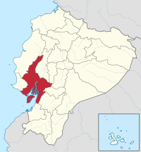
- Cotacachi Canton, Imbabura Province, Ecuador
- Eastern Tena Canton, Napo Province, Ecuador
- Balzar and El Empalme Cantons, Guayas Province, Ecuador
- Southern San Miguel Department, El Salvador
- Northern East Berbice-Corentyne, Guyana
- Norte, Jalisco, Mexico
- Eastern Tabasco, Mexico
- Southeastern Zacatecas, Mexico
- Southern Zacatecas, Mexico
- Chiriquí Grande District, Bocas del Toro Province, Panama
- Southern Chimán District, Panamá Province, Panama
- Mariato District, Veraguas Province, Panama
- Caravelí Province, Arequipa Region, Peru
- Northern Tapanahony, Sipaliwini District, Suriname
- Páez, Apure, Venezuela
- Western Andrés Eloy Blanco Municipality, Barinas, Venezuela
- Arismendi Municipality, Barinas, Venezuela
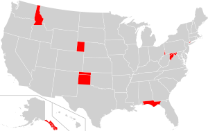
Panhandles in the United States
| State | Largest city | Population | Area (sq mi) | Area (km2) | Population density (per sq mi) |
Population density (/km2) |
|---|---|---|---|---|---|---|
| Alaska | Juneau | 71,616 | 35,138 | 91,010 | 2 | 0.77 |
| Connecticut | Stamford | 224,284 | 96 | 250 | 2,336 | 902 |
| Florida[a] | Tallahassee | 1,407,925 | 11,304 | 29,280 | 125 | 48 |
| Idaho | Coeur d'Alene | 317,751 | 21,013 | 54,420 | 15 | 5.8 |
| Maryland[b] | Frederick | 492,950 | 2,194 | 5,680 | 225 | 87 |
| Nebraska | Scottsbluff | 87,789 | 14,258 | 36,930 | 6 | 2.3 |
| Oklahoma | Guymon | 28,751 | 5,687 | 14,730 | 5 | 1.9 |
| Texas | Amarillo | 427,927 | 25,887 | 67,050 | 17 | 6.6 |
| Eastern West Virginia | Martinsburg | 261,041 | 3,499 | 9,060 | 75 | 29 |
| Northern West Virginia | Wheeling | 132,295 | 601 | 1,560 | 220 | 85 |
Subnational salients in Asia


- Wakhan District, Badakhshan Province, Afghanistan
- Nawa District, Ghazni Province, Afghanistan
- Chishti Sharif District, Herat Province, Afghanistan
- Eastern Sarpang District, Bhutan
- Northern Mandalay Division, Burma
- Tianchang, Anhui, China PR
- Maqu County, Gansu, China PR
- Fan County and Taiqian County, Henan, China PR
- Pingliang and Qingyang, Gansu, China PR
- Daxing'anling Prefecture, Heilongjiang, China PR
- Zhaotong, Yunnan, China PR
- Koraput and Malkangiri districts, Odisha, India
- Pathankot district, Punjab, India
- Kota division, Rajasthan, India
- Southern Jhansi division, Uttar Pradesh, India
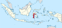
- Eastern salient of Java, East Java, Indonesia[c]
- South Jakarta, Jakarta Special Capital Region, and Depok, West Java, Indonesia.
- Tabalong Regency, South Kalimantan, Indonesia
- East Luwu Regency, South Sulawesi, Indonesia
- Pasaman Regency, West Sumatra, Indonesia
- Semirom County, Isfahan Province, Iran
- Southwest Razavi Khorasan Province, Iran
- Southern Yazd Province, Iran
- Noda, Chiba, Japan
- Nose, Osaka, Japan
- Ōra District, Gunma, Japan
- Reinan(Wakasa), Fukui, Japan
- Wadi Araba Department, Aqaba Governorate, Jordan
- Russeifa Department, Zarqa Governorate, Jordan
- Southwest Panfilov District, Chuy Region, Kyrgyzstan
- Chong-Alay District, Osh Region, Kyrgyzstan
- Nabatieh District, Nabatieh Governorate, Lebanon
- Bandar Baharu District, Kedah, Malaysia
- Northeast of Kuantan District, Eastern Pahang, Malaysia
- South of Kemaman District, Terengganu, Malaysia
- Eastern Achham District, Far-Western Region, Nepal
- Western Surkhet District, Mid-Western Region, Nepal
- Bannu, Karak, and Kohat Divisions, Khyber Pakhtunkhwa, Pakistan
- Tiwi, Albay, Philippines
- Northernmost portion of barangay San Isidro, Cainta, Rizal, Philippines[1]
- Northwestern Cagayan, Philippines
- Libis/Reparo, Santa Quiteria and Talipapa of southern Caloocan, Philippines
- Carmona, Cavite, Philippines
- Northeastern Ilocos Sur (roughly corresponding to its 1st district), Philippines
- Barangays Casile and Pittland, Cabuyao, Laguna, Philippines
- Santa Maria, Laguna, Philippines
- Las Piñas, Philippines (Almanza Dos)
- Eastern Maguindanao del Sur, Philippines (municipalities east of Sultan sa Barongis)
- Carranglan, Nueva Ecija, Philippines
- Alfonso Castañeda, southern Dupax del Norte and Dupax del Sur, Nueva Vizcaya, Philippines
- Eastern Sultan Kudarat (roughly corresponding to its 1st district, excluding Isulan), Philippines
- Bikinsky District, Khabarovsk Krai, Russia
- Trincomalee District, Eastern Province, Sri Lanka
- Al-Suqaylabiyah District, Hama Governorate, Syria
- Chenggong and Changbin townships, Taitung County, Taiwan
- Darvoz District, Gorno-Badakhshan Autonomous Region, Tajikistan
- Western Dhamar Governorate, Yemen
Subnational salients in Europe

- Southern Gmunden, Upper Austria, Austria
- Pancharevo, Sofia City Province, Bulgaria
- Kuhmoinen, Pirkanmaa, Finland
- Parikkala, South Karelia, Finland
- Pudasjärvi-Taivalkoski-Kuusamo, North Ostrobothnia, Finland
- Ruokolahti, South Karelia, Finland
- Varkaus, Pohjois-Savo, Finland
- Gironde, France (panhandle is around the Gironde estuary)
- Drôme, France (Montfroc)
- Hauts-de-Seine, France
- Meurthe-et-Moselle, France
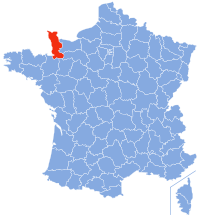
- Manche, France
- Lower Franconia, Bavaria, Germany
- Osnabrück District and City, Lower Saxony, Germany
- Altenburger Land, Thuringia, Germany
- Southeastern Mureș County, Romania
- Southeastern Győr-Moson-Sopron County, Hungary
- Northern Pest County, Hungary
- Clonlisk, County Offaly, Ireland
- Tullyhaw, County Cavan, Ireland
- Province of Rieti, Lazio, Italy
- Raseiniai District Municipality, Kaunas County, Lithuania
- Dieveniškės, Vilnius County, Lithuania
- Rivierenland, Gelderland, the Netherlands
- Steenwijkerland, Overijssel, the Netherlands
- Viken, Norway
- Mourão, Évora District, Portugal
- Vorkuta District, Komi Republic, Russia
- Negueira de Muñiz, Galicia (Spain), Spain
- Aranjuez, Madrid (Spain), Spain
- A Mezquita, Galicia, Spain
- Diessenhofen, Schlatt bei Diessenhofen, and Basadingen-Schlattingen, Frauenfeld District, Thurgau, Switzerland
- Monthey District, Valais, Switzerland
- Buckfastleigh, Teignbridge, United Kingdom
- Ceiriog Valley, Wrexham County Borough, Wales, United Kingdom
- English Maelor, Wrexham County Borough, Wales, United Kingdom
- Western New Forest District, Hampshire, United Kingdom
- Newmarket, Suffolk, United Kingdom
- North Cornwall, Cornwall, United Kingdom
- Stamford, Lincolnshire, United Kingdom
- South Staffordshire, Staffordshire, United Kingdom
- The area around Tring, Hertfordshire, United Kingdom, which is itself bounded on one side by a salient of Buckinghamshire in the area around Pitstone, Ivinghoe and Dagnall
- Ljig, Kolubara District, Serbia
- Ljubovija, Mačva District, Serbia
- Bosnian-Podrinje Canton Goražde, Federation of Bosnia and Herzegovina, Bosnia and Herzegovina
- Petrovo, Republika Srpska, Bosnia and Herzegovina
- Ravno, Herzegovina-Neretva Canton, Bosnia and Herzegovina
Subnational salients in Oceania

- Northeastern Nadroga-Navosa Province, Western Division, Fiji
- Southern Anetan District, Nauru
- Rangitaiki River Valley, Bay of Plenty Region, New Zealand
- Hunter River Valley, Otago region, New Zealand
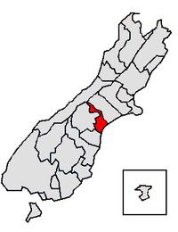
- Upper Rangitata Valley, Timaru District, New Zealand
- Upper Waitaki Valley, Waitaki District, New Zealand
- Northeastern West New Britain Province, Papua New Guinea
See also
- Bootheel
- Border irregularities of the United States
- Border
- Chicken's Neck (disambiguation)
- Corridor (disambiguation)
- Enclave and exclave
- Fergana Valley (triple junction of Uzbekistan, Kyrgyzstan and Tajikistan)
- Gerrymandering
- Political geography
- Salients, re-entrants and pockets
- The Thumb
Notes
- ^ This definition includes the following counties: Bay, Calhoun, Escambia, Franklin, Gadsden, Gulf, Holmes, Jackson, Jefferson, Leon, Liberty, Madison, Okaloosa, Santa Rosa, Taylor, Wakulla, Walton, and Washington.
- ^ This definition includes the following counties: Allegany, Frederick, Garrett, and Washington
- ^ Not a geopolitical salient, but a normal geographical feature similar to that of a peninsula.
References
- ^ "San Isidro". Google Maps. Google LLC. Retrieved 14 January 2020.
Further reading
- Robert Reid (4 April 2016). "America's Panhandles, Ranked From 1 to 10". National Geographic. Retrieved 2019-05-16.