
Maqu County
རྨ་ཆུ་རྫོང་། · 玛曲县 | |
|---|---|
 | |
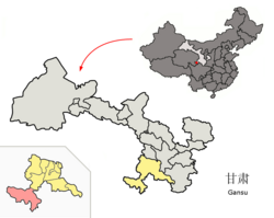 Maqu County (red) within Gannan Prefecture (yellow) and Gansu | |
 Maqu Location of the seat in Gansu  Maqu Maqu (China) | |
| Coordinates (Maqu government): 33°59′52″N 102°04′22″E / 33.9977°N 102.0727°E | |
| Country | China |
| Province | Gansu |
| Autonomous prefecture | Gannan |
| County seat | Nyinma (Nima) |
| Area | |
| • Total | 10,190 km2 (3,930 sq mi) |
| Population (2020)[1] | |
| • Total | 57,076 |
| • Density | 5.6/km2 (15/sq mi) |
| Time zone | UTC+8 (China Standard) |
| Postal code | 747300 |
| Website | www |
| Maqu County | |||||||
|---|---|---|---|---|---|---|---|
| Chinese name | |||||||
| Simplified Chinese | 玛曲县 | ||||||
| Traditional Chinese | 瑪曲縣 | ||||||
| |||||||
| Tibetan name | |||||||
| Tibetan | རྨ་ཆུ་རྫོང་། | ||||||
| |||||||
Maqu County (Chinese: 玛曲县; Tibetan: རྨ་ཆུ་རྫོང་།) is a county of the Gannan Tibetan Autonomous Prefecture in the south of Gansu province of China, bordering the provinces of Sichuan to the east and southeast, and Qinghai to the southwest, west and northwest. Its postal code is 747300, and in 1999 its population was 36,213 people.[2] The word "Maqu" derived from the Tibetan name of Yellow River. The area of Maqu County is 10,191 km2 with an average altitude of 3,700 meters.[3] Maqu County receives high rainfall and is located at the northern edge of the Zoigê Marshes on the Yellow River where conditions are optimal for alpine meadow vegetation.[3]
YouTube Encyclopedic
-
1/5Views:3164876611 266698
-
Maqu wetland in China's Gansu Province | CCTV English
-
Gannan Tibetan Autonomous Prefecture. China
-
Visit Gansu and its fascinating landscapes
-
Xiahe Gansu province China
-
By the Yellow River 1st of January
Transcription
Administrative divisions
Maqu County is divided to 6 towns and 2 townships.[4]
| Name | Simplified Chinese | Hanyu Pinyin | Tibetan | Wylie | Administrative division code | |
|---|---|---|---|---|---|---|
| Towns | ||||||
| Nyinma Town (Nima) |
尼玛镇 | Nímǎ Zhèn | ཉིན་མ་གྲོང་རྡལ། | nyin ma grong rdal | 623025100 | |
| Maima Town (Manrima) |
曼日玛镇 | Mànrìmǎ Zhèn | སྨད་མ་གྲོང་རྡལ། | smad ma grong rdal | 623025101 | |
| Waibaincang Town (Bainaincang, Awancang) |
阿万仓镇 | Āwàncāng Zhèn | དབལ་བན་ཚང་གྲོང་རྡལ། | dbal ban tshang grong rdal | 623025102 | |
| Qukama Town (Qihama) |
齐哈玛镇 | Qíhāmǎ Zhèn | ཆུ་ཁ་མ་གྲོང་རྡལ། | chu kha ma grong rdal | 623025103 | |
| Cêruma Town (Cairima) |
采日玛镇 | Cǎirìmǎ Zhèn | མཚེ་རུ་མ་གྲོང་རྡལ། | mtshe ru ma grong rdal | 623025104 | |
| Ngüra Town (Oula) |
欧拉镇 | Ōulā Zhèn | དངུལ་རྭ་གྲོང་རྡལ། | dngul rwa grong rdal | 623025105 | |
| Townships | ||||||
| Ngüraxoima Township (Oulaxiuma) |
欧拉秀玛乡 | Ōulāxiùmǎ Xiāng | དངུལ་རྭ་ཞོལ་མ་ཤང་། | dngul rwa zhol ma shang | 623025201 | |
| Murqêg Township (Murqê, Muxihe) |
木西合乡 | Mùxīhé Xiāng | མུར་བྱེག་ཤང་། | mur byeg shang | 623025203 | |
Climate
| Climate data for Maqu (1991–2020 normals, extremes 1981–2010) | |||||||||||||
|---|---|---|---|---|---|---|---|---|---|---|---|---|---|
| Month | Jan | Feb | Mar | Apr | May | Jun | Jul | Aug | Sep | Oct | Nov | Dec | Year |
| Record high °C (°F) | 14.5 (58.1) |
14.8 (58.6) |
18.4 (65.1) |
23.6 (74.5) |
22.4 (72.3) |
23.4 (74.1) |
25.1 (77.2) |
24.7 (76.5) |
23.5 (74.3) |
19.8 (67.6) |
15.0 (59.0) |
13.6 (56.5) |
25.1 (77.2) |
| Average high °C (°F) | 0.5 (32.9) |
3.2 (37.8) |
6.4 (43.5) |
10.3 (50.5) |
13.0 (55.4) |
15.2 (59.4) |
17.6 (63.7) |
17.5 (63.5) |
14.3 (57.7) |
9.5 (49.1) |
5.3 (41.5) |
1.5 (34.7) |
9.5 (49.1) |
| Daily mean °C (°F) | −8.3 (17.1) |
−5.3 (22.5) |
−1.3 (29.7) |
3.0 (37.4) |
6.4 (43.5) |
9.7 (49.5) |
11.8 (53.2) |
11.3 (52.3) |
8.0 (46.4) |
2.7 (36.9) |
−2.9 (26.8) |
−7.2 (19.0) |
2.3 (36.2) |
| Average low °C (°F) | −15.4 (4.3) |
−12.2 (10.0) |
−7.2 (19.0) |
−2.7 (27.1) |
1.1 (34.0) |
4.9 (40.8) |
6.8 (44.2) |
6.2 (43.2) |
3.4 (38.1) |
−2.0 (28.4) |
−8.8 (16.2) |
−14.1 (6.6) |
−3.3 (26.0) |
| Record low °C (°F) | −28.0 (−18.4) |
−27.3 (−17.1) |
−20.9 (−5.6) |
−13.6 (7.5) |
−8.9 (16.0) |
−3.4 (25.9) |
−2.7 (27.1) |
−4.0 (24.8) |
−7.0 (19.4) |
−12.9 (8.8) |
−22.4 (−8.3) |
−26.8 (−16.2) |
−28.0 (−18.4) |
| Average precipitation mm (inches) | 5.8 (0.23) |
6.3 (0.25) |
15.2 (0.60) |
29.0 (1.14) |
71.8 (2.83) |
101.0 (3.98) |
126.0 (4.96) |
116.9 (4.60) |
88.1 (3.47) |
43.7 (1.72) |
6.7 (0.26) |
1.8 (0.07) |
612.3 (24.11) |
| Average precipitation days (≥ 0.1 mm) | 4.9 | 5.3 | 9.6 | 12.3 | 17.8 | 19.8 | 19.3 | 17.9 | 18.5 | 14.5 | 4.1 | 2.6 | 146.6 |
| Average snowy days | 6.5 | 7.4 | 12.9 | 12.6 | 7.7 | 1.3 | 0.2 | 0.1 | 2.0 | 10.3 | 6.0 | 4.2 | 71.2 |
| Average relative humidity (%) | 45 | 46 | 52 | 58 | 66 | 71 | 74 | 75 | 76 | 70 | 55 | 46 | 61 |
| Mean monthly sunshine hours | 229.4 | 207.9 | 228.5 | 230.1 | 219.3 | 186.9 | 217.6 | 219.9 | 173.7 | 195.8 | 229.1 | 234.1 | 2,572.3 |
| Percent possible sunshine | 72 | 67 | 61 | 59 | 51 | 43 | 50 | 54 | 48 | 57 | 74 | 77 | 59 |
| Source: China Meteorological Administration[5][6] | |||||||||||||
See also
References
- ^ "甘南州第七次全国人口普查公报" (in Chinese). Government of Gannan Prefecture. 2021-05-27.
- ^ "HGIS - Downloads". Archived from the original on 2008-08-28. Retrieved 2008-10-12.
- ^ a b "China". Archived from the original on 2007-08-18. Retrieved 2012-12-04.
- ^ "统计用区划代码 www.stats.gov.cn" (in Chinese). XZQH. Retrieved 2012-05-26.
- ^ 中国气象数据网 – WeatherBk Data (in Simplified Chinese). China Meteorological Administration. Retrieved 27 August 2023.
- ^ 中国气象数据网 (in Simplified Chinese). China Meteorological Administration. Retrieved 27 August 2023.
This Gansu location article is a stub. You can help Wikipedia by expanding it. |