
Bannu Division
بنوں ڈویژن بنو څانګه | |
|---|---|
    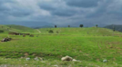 Images, from top down, left to right: The city of Bannu; A village in Lakki Marwat District; The Kurram River at Bannu; A scene in North Waziristan; Another scene in North Waziristan | |
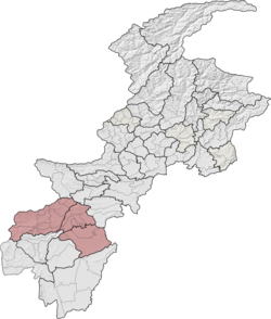 Bannu Division (red) in Khyber Pakhtunkhwa | |
| Coordinates: 32°40′00″N 70°36′00″E / 32.66667°N 70.60000°E | |
| Country | |
| Province | |
| Government | |
| • Type | Divisional Administration |
| • Commissioner | Parwaiz Sabatkhel (BPS-20 PCS) |
| • Regional Police Officer | Syed Ashfaq Anwar (BPS-20 PSP) |
| Area | |
| • Total | 9,975 km2 (3,851 sq mi) |
| Population | |
| • Total | 2,656,801 |
| • Density | 270/km2 (690/sq mi) |
| Time zone | UTC+5 (PST) |
| National Assembly Seats (2018) [3] | Total (3) B |
| Khyber Pakhtunkhwa Assembly Seats (2018) [4][5] | Total (9) |
| Website | cbd |
Bannu Division is one of seven divisions in Pakistan's Khyber Pakhtunkhwa province. It consists of three districts: Bannu, Lakki Marwat, and North Waziristan.[2][6] According to the 2017 Pakistani Census, the division had a population of 2,656,801,[2] making it the least populous division in the province, but it spans 9,975 km2 (3,851 sq mi) of area,[1] and this makes it the third-smallest division by area in the province. Lakki Marwat is the largest city of Bannu Division, with around 60,000 people, while the division's namesake and second-largest city is Bannu, with just under 50,000 people. The division borders Dera Ismail Khan Division to the south and west, Kohat Division to the north and east, and the province of Punjab, Pakistan to its east. CNIC code of Bannu Division is 11.
YouTube Encyclopedic
-
1/2Views:32 445452
-
Travel To Bannu in Urdu & Hindi بنوں کی سیر | Amazing History and Documentary of Bannu Story
-
Bannu Abbas urdu/hindi part 03 | Al Mamun al Rasheed | Fight for the throne | Anarchy at Samarra
Transcription
Districts
Districts are the administrative unit one level below divisions in the administrative hierarchy of Pakistan. Bannu Division consists of the following three districts:[6]
| District | Population (2017) [2] | Total Area [1] | Population Density (2017) | Map |
|---|---|---|---|---|
| Bannu District | 1,211,006 | 1,972 km2 (761 sq mi) | 614.10/km2 (1,590.5/sq mi) | 
|
| Lakki Marwat District | 902,541 | 3,296 km2 (1,273 sq mi) | 273.83/km2 (709.2/sq mi) | 
|
| North Waziristan District | 543,254 | 4,707 km2 (1,817 sq mi) | 115.41/km2 (298.9/sq mi) | 
|
| Division Total | 2,656,801 | 9,975 km2 (3,851 sq mi) | 266.35/km2 (689.8/sq mi) |
History

In 1941, the area which today covers the division (excluding North Waziristan) was known as Bannu District. The Bannu District was one of five trans-Indus districts in the North-West Frontier Province of British India, and it was split into the tehsils of Bannu and Marwat.[7] Here is a description of the area given by the Imperial Gazetteer of India.
One of the four trans-Indus Districts of the North-West Frontier Province, lying between 32° 16'N and 33°5′N and between 70°23'E and 71°16′E, with an area of 1,670 square miles. The District forms a basin drained by two rivers from the hills of Waziristan, the Kurram River and the Gambila or Tochi, which unite at Lakki and flow into the Indus south of Kalabagh. It is shut in on every side by mountains: on the north by those in the Teri tahsil of Kohat District; on the east by the southern extremity of the Maidani Pahar or Khattak Niazi range and the northern spur of the Marwat range, which separate the District from the Isa Khel tahsil of Mianwali District in the Punjab; on the south-east and south the Marwat and Bhittanni ranges divide it from Dera Ismail Khan; and on the west and north-west lie Waziristan and independent territory inhabited by the Bhittanni tribe. These hills nowhere attain any great height. The highest point of the Maidani range at its centre, near the hamlet and valley of Maidan, has an altitude of only 4,256 feet. The Marwat range culminates in Sheikh Budin, the hill which rises abruptly from its south-west end to a height of 4,516 feet, and forms the summer retreat for this District and Dera Ismail Khan. From these ranges numerous spurs jut out into the Bannu plains, but no other hills break their level expanse. Of the rivers the larger is the Kurram, which, entering the District at its north-western corner close to Bannu town, runs at first south-east, then south, and finally winds eastward through the Darra Tang or 'narrow gorge' which lies between the extremities of the Maidani Pahar and Marwat ranges. The Tochi river enters the District about 6 miles south of the Kurram and flows in the same direction, gradually drawing closer to it until their streams unite about 6 or 7 miles west of the Darra Tang.
North Waziristan, on the other hand, was an agency in the province bordering Bannu District. It is also described in the Gazetteer.
Political Agency in the North-West Frontier Province, lying between 32° 45' and 33° 15' N. and 69° 30' and 70° 40' E., with an area of about 2,310 square miles. It is bounded on the north and east by the Districts of Kohāt and Bannu, and on the south by the Shaktu stream, from the point where it enters the latter district Shuidār at its head. From Shuidār the boundary follows the eastern watershed of the Shawāl valley as far as Drenashtar Sar, and then runs north-east along the Durand Line to Kohisar in the country of the Kābul Khel Wazīrs and Biland Khel. The Agency thus comprises four large and fertile valleys: in the north, the Lower Kurram valley between the Kurram Agency on the upper reaches of that river and Bannu District; the Kaitu Valley; Daur in the valley of the Tochi, the most open and fertile of the four; and the Khaisora valley in the south. Between the Kaitu and Tochi lie the Sheratulla and, north of Miram Shāh, the Dande — two barren plains, each about 30 square miles in area. Another plateau, called the Spereghāra, similar to the Sheratulla but smaller, lies between the Kurram and the Kaity. With these exceptions, the valleys are separated by high barren hills. The loftiest peak is Shuidār (11,000 feet), at the western end of the Khaisora valley.
After independence, Bannu District became a part of the then-much-larger Dera Ismail Khan Division.[1]
The area received full-fledged division status between the Pakistani censuses of 1981 and 1998, and during the same time period, Lakki Marwat Tehsil (having been renamed from Marwat Tehsil) was also upgraded, to district status (becoming Lakki Marwat District).[1]
In August 2000, Bannu Division was abolished along with every other division in the country, but was reinstated (with all the other divisions of Pakistan) eight years later after the elections of 2008.
In 2018, the 25th Amendment to the Constitution of Pakistan was passed by the Parliament of Pakistan and the Khyber Pakhtunkhwa Assembly. This entirely and fully merged the seven agencies of the Federally Administered Tribal Areas and the six Frontier Regions with the province of Khyber Pakhtunkhwa. With this merger, Bannu Division gained the agency of North Waziristan, which became a district, the Frontier Region Bannu (which was fully merged into Bannu District as Wazir Subdivision), and the Frontier Region Lakki Marwat (which was fully merged into Lakki Marwat District as Bettani Subdivision).[6]
Geography
Bannu Division has a total area of 9,975 km2 (3,851 sq mi).[1] North Waziristan District is the largest district in the division, with 4,707 km2 (1,817 sq mi) of area, which means it takes up 47.19% of the area of the entire division! Lakki Marwat District is the second-largest district of the division, and it takes up an area of 3,296 km2 (1,273 sq mi), or 33.04% of the area of the division. Bannu District only has an area of 1,972 km2 (761 sq mi), which means it barely takes up a fifth of the division's area.
The important Kurram River (a major tributary of the Indus River) flows through the division, flowing through North Waziristan District, Bannu District (where it flows near the namesake of the division, Bannu), and Lakki Marwat District (where it flows near the largest city in the division, Lakki Marwat), before it exits the division through the border with Punjab, where it will join the Indus.
Surrounding areas
To Bannu Division's northwest, you will find Kohat Division, to the division's west and southwest, Dera Ismail Khan Division can be found. To the southeast of Bannu Division, Sargodha Division in the province of Punjab can be found, and Bannu Division borders the country of Afghanistan to its west.
Demographics
| Year | Pop. | ±% p.a. |
|---|---|---|
| 1901 | 231,485 | — |
| 1911 | 394,465 | +5.47% |
| 1921 | 385,593 | −0.23% |
| 1931 | 363,871 | −0.58% |
| 1941 | 398,693 | +0.92% |
| 1951 | 458,194 | +1.40% |
| 1961 | 587,531 | +2.52% |
| 1972 | 881,764 | +3.76% |
| 1981 | 1,099,602 | +2.48% |
| 1998 | 1,553,518 | +2.05% |
| 2017 | 2,656,801 | +2.86% |
| Source: [7][1][2] | ||
As of the 2017 Census of Pakistan, the division had a population of 2,656,801,[2] out of which there were 1,351,450 males, 1,305,326 females, and 25 people who identified as Intersex; this made the sex ratio of the division 1,035 males for every 1,000 females. The division had 284,583 households, making the average household size of the division 9.34. This was the highest household size in the country in 2017. 143,746 people in the division lived in an urban area, but the overwhelming majority (2,513,055) lived in a rural area, making the urbanization rate of the division a mere 5.72%[10] While geographically, it is the third-smallest division in the province of Khyber Pakhtunkhwa, it is the least populated, with a population density of 266.35/km2 (689.8/sq mi), making it the third-least densely populated division in the province.[citation needed]
Bannu Division had four urbanized areas in 2017, the lowest amount out of any division in the entire province, and its most populous city, Lakki Marwat, had a population of 59,465,[11] and that made it the smallest city in the province that was classified as the largest city of its own division, and it only was the 20th largest city in the entire province. Bannu, the namesake of the division, in Bannu District, was the second-largest city in the division and the 25th largest in the province, with a population of 49,965.[12] The city of Bannu, though, was the largest city in the division, in 1998, but its population stagnated throughout the period of time between 1998 and 2017, growing only 0.25% every year. The other two urbanized areas in the province are the town of Sarai Naurang of Lakki Marwat District, with a population of 29,955,[11] and the only urbanized area in North Waziristan District (and the whole region of Waziristan), Miranshah, which had a population of 4,361 in 2017.[13]
The division has one cantonment, the Bannu Cantonment, adjacent to the city of Bannu which had a population of 8,320, making up the division's entire military population.[12] This made 0.31% of the entire population of the division active military personnel.
See also
- Divisions of Pakistan
- Divisions of Khyber Pakhtunkhwa
- Bannu District
- Lakki Marwat District
- North Waziristan District
- Administrative units of Pakistan
- Districts of Khyber Pakhtunkhwa
Notes
- A. ^ Before 2018, the North Waziristan Agency (now North Waziristan District), the Frontier Region Bannu, and the Frontier Region Lakki Marwat were not a part of Bannu Division, but were a part of the Federally Administered Tribal Areas outside Khyber Pakhtunkhwa.
- B. ^ There were only three constituencies solely inside Bannu Division at the time of the 2018 Pakistani general election, but there was a fourth constituency, NA-51, that was made of regions from different divisions. NA-51 covered the Frontier Region Bannu and the Frontier Region Lakki Marwat in Bannu Division, but together those areas only make up 19.42% of the population of the constituency and 2.61% of the population of the division, so it is omitted in the infobox. That seat was won by Muttahida Majlis-e-Amal.
- C. ^ At the time of the 2018 Pakistani general election, Bannu District sent four representatives to the KPK Assembly and Lakki Marwat District sent three, but elections were held a year later (in 2019) in the areas of Khyber Pakhtunkhwa that were formerly part of the Federally Administered Tribal Areas. At the time of the 2019 elections, North Waziristan elected two representatives, which add up to nine for the entire division. Once again, though, there was another constituency, PK-115, that was made of regions from different divisions. PK-115 (just like NA-51) covered the Frontier Region Bannu and the Frontier Region Lakki Marwat in Bannu Division, but together those areas only make up 19.42% of the population of the constituency and 2.61% of the population of the division, so it is omitted in the infobox. That seat was won by Jamiat Ulema-e-Islam (F).[14]
References
- ^ a b c d e f g "1951 - 1998 POPULATION OF ADMINISTRATIVE UNITS (AS ON 1st MARCH 1998)" (PDF). 1951-98 Population of Administrative Units (As on 1st March, 1998).pdf. POPULATION CENSUS ORGANIZATION STATISTICS DIVISION GOVERNMENT OF PAKISTAN. January 2002. Archived (PDF) from the original on 23 August 2020. Retrieved 25 August 2020.
- ^ a b c d e f "PROVINCE WISE PROVISIONAL RESULTS OF CENSUS - 2017" (PDF). PAKISTAN TEHSIL WISE FOR WEB CENSUS_2017.pdf. Pakistan Bureau of Statistics. Archived from the original (PDF) on 16 June 2020. Retrieved 16 June 2020.
- ^ "The Gazette of Pakistan Election Commission of Pakistan Notification" (PDF). National Assembly1.pdf. Election Commission of Pakistan. Archived from the original (PDF) on 21 June 2020. Retrieved 21 June 2020.
- ^ "The Gazette of Pakistan Election Commission of Pakistan Notification" (PDF). Provincial KPK1.pdf. Election Commission of Pakistan. Archived from the original (PDF) on 21 June 2020. Retrieved 21 June 2020.
- ^ "NOTIFICATION REGARDING RETURNED CANDIDATES OF PK-100 TO PK-114 (ERSTWHILE FATA)". ECP - Election Commission of Pakistan. Election Commission of Pakistan. 1 August 2019. Archived from the original on 21 July 2020. Retrieved 21 July 2020.
- ^ a b c "KP govt notifies new divisions following FATA merger". KP govt notifies new divisions following FATA merger | Pakistan Today. Pakistan Today. 20 July 2018. Archived from the original on 2 July 2020. Retrieved 2 July 2020.
- ^ a b Scott, I.D. "CENSUS OF INDIA, 1941 VOLUME X" (PDF). North-West Frontier Province, Volume X. Government of India. Archived (PDF) from the original on 22 June 2020. Retrieved 22 June 2020.
- ^ Bannu District - Imperial Gazetteer of India, v. 6, p. 392.
- ^ Wazīristān, Northern - Imperial Gazetteer of India, v. 24, p. 379.
- ^ "TABLE - 1: PROVISIONAL PROVINCE WISE POPULATION BY SEX AND RURAL/URBAN CENSUS - 2017 PAKISTAN" (PDF). DISTRICT_WISE_CENSUS_RESULTS_CENSUS_2017.pdf. Pakistan Bureau of Statistics. Archived from the original (PDF) on 21 June 2020. Retrieved 21 June 2020.
- ^ a b "POPULATION AND HOUSEHOLD DETAIL FROM BLOCK TO DISTRICT LEVEL KHYBER PAKHTUNKHWA (LAKKI MARWAT DISTRICT)" (PDF). LAKKI MARWAT_BLOCKWISE.pdf. Pakistan Bureau of Statistics. 3 January 2018. Archived from the original (PDF) on 21 June 2020. Retrieved 21 June 2020.
- ^ a b "POPULATION AND HOUSEHOLD DETAIL FROM BLOCK TO DISTRICT LEVEL KHYBER PAKHTUNKHWA (BANNU DISTRICT)" (PDF). BANNU_BLOCKWISE.pdf. Pakistan Bureau of Statistics. 3 January 2018. Archived from the original (PDF) on 20 June 2020. Retrieved 20 June 2020.
- ^ "POPULATION AND HOUSEHOLD DETAIL FROM BLOCK TO DISTRICT LEVEL FATA (NORTH WAZIRISTAN AGENCY)" (PDF). NORTH_WAZIRISTAN_AGENCY_BLOCKWISE.pdf. Pakistan Bureau of Statistics. 3 January 2018. Archived from the original (PDF) on 10 July 2020. Retrieved 20 June 2020.
- ^ "ECP - Election Commission of Pakistan". PK-115 RETURNED CANDIDATE NOTIFICATION. Election Commission of Pakistan. 3 August 2019. Retrieved 21 July 2020.
Pakistan articles | |||||||||||||||||||
|---|---|---|---|---|---|---|---|---|---|---|---|---|---|---|---|---|---|---|---|
| |||||||||||||||||||
| |||||||||||||||||||
| |||||||||||||||||||
| |||||||||||||||||||
| |||||||||||||||||||
