To install click the Add extension button. That's it.
The source code for the WIKI 2 extension is being checked by specialists of the Mozilla Foundation, Google, and Apple. You could also do it yourself at any point in time.
How to transfigure the Wikipedia
Would you like Wikipedia to always look as professional and up-to-date? We have created a browser extension. It will enhance any encyclopedic page you visit with the magic of the WIKI 2 technology.
Try it — you can delete it anytime.
Install in 5 seconds
Yep, but later
4,5
Kelly Slayton
Congratulations on this excellent venture… what a great idea!
Alexander Grigorievskiy
I use WIKI 2 every day and almost forgot how the original Wikipedia looks like.
Kingston is a former town that was originally in Fresno County, until 1909 when that territory south of Kings River was transferred to Kings County, California.[1] It was located on the south bank of the Kings River 8.5 miles (13.7 km) northwest of Hanford at Whitmore's Ferry.[1]
L. A. Whitmore established the ferry in 1854.[1] It was founded in 1856 by Lucious A. Whitmore who operated the first ferry to cross the Kings River. The town of Kingston grew up around the ferry at the place where an old Spanish road called El Camino Viejo á Los Angeles (The Old Road to Los Angeles) crossed the river. Kingston became a stopping place on the Butterfield Overland Mail route from 1858 to 1861 and a stage route between Stockton and Visalia after 1858. A post office operated at Kingston from 1859 to 1862, and from 1866 to 1890, when the service transferred to Lillis.[2] Until at least 1872, the only store between Millerton and Visalia was in Kingston. The first school in the area was probably the one established as early as 1860 in Kingston.[3]
Oliver H. Bliss operated the Kingston ferry after Whitmore, beginning in 1859. Bliss built a temporary toll bridge with two boats and planking in 1872. In 1873, John Sutherland purchased Bliss's interest in both the ferry and the bridge and built a permanent bridge that year.
On December 26, 1873, Tiburcio Vásquez and his bandit gang made a bold raid, robbing the entire village. Reportedly 35 or more men were tied up and over $2,000 in loot was hauled away. Subsequently, the town declined and by the 1890s Kingston was abandoned. Oliver Bliss' livery stable was the last remaining building and stood until 1930.[4]
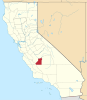
The site of the town is now a California Historical Landmark (#270), which can be found in Kingston-Laton County Park in Kings County.[5]
References
^ abcDurham, David L. (1998). California's Geographic Names: A Gazetteer of Historic and Modern Names of the State. Clovis, Calif.: Word Dancer Press. p. 1044. ISBN1-884995-14-4.
Fort Tejon – Located 15 miles southwest of Sink of Tejon Station, north of and below the summit of Tejon Pass.
Reed's Station – Located 8 miles southeast of Fort Tejon, near, to the south of the summit of the Tejon Pass.
French John's Station – Located 14 miles east southeast of Reeds Station, in the vicinity of the mouth of Cow Springs Creek Canyon.
Mud Spring, a later station operating in 1860, 14 miles east from French Johns and 13 miles north from Clayton's Station (formerly Widow Smith's Station). [1]