
Fachi
Agram | |
|---|---|
Commune | |
 | |
 Fachi | |
| Coordinates: 18°3′48″N 11°36′22″E / 18.06333°N 11.60611°E | |
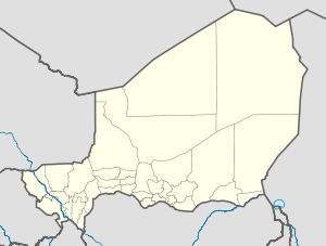
| Country | Niger |
| Region | Agadez Region |
| Department | Bilma Department |
| Commune | Fachi |
| Area | |
| • Total | 35,536 km2 (13,721 sq mi) |
| Elevation | 593 m (1,948 ft) |
| Population (2012 census) | |
| • Total | 2,215 |
| • Density | 0.062/km2 (0.16/sq mi) |
| Time zone | UTC+1 (WAT) |
| [1] | |
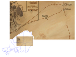
Fachi is an oasis surrounded by the Ténéré desert and the dunes of the Erg of Bilma in eastern Niger, placed on the western edge of the small Agram mountain outcropping. It has a population of 2,215 people (2012).[2] It is also a stopping point of the Agadez to the Kaouar caravans of the Azalay. Fachi is 240 kilometres (150 miles) west of Bilma and 320 km (200 mi) east of the Aïr Mountains. Apart from water, dates, and salt, Fachi produces no provisions, and depends entirely upon trade in these products with passing caravans.
Frequently raided by Tuareg and Bedouins in its past, the town is built within high fortifications, known locally as a ksar, built from banco salt blocks; they are now unused.
Fachi's population is largely from the Kanuri and Toubou peoples, in whose language the town is called Agram. Fachi, its official name, is from Tuareg and Hausa peoples, who at one time lived there in larger numbers.
YouTube Encyclopedic
-
1/3Views:8762 872769
-
Fachi oasis, Tenere, Niger
-
tuti vs fachi
-
NIGER - Fachi - Scuola coranica
Transcription
References
- ^ Fachi, Niger Page. Falling Rain Genomics, Inc. 1996–2004
- ^ "Fachi (Commune, Niger) - Population Statistics, Charts, Map and Location". www.citypopulation.de. Retrieved 2024-02-16.
- Samuel Decalo. Historical Dictionary of Niger. Scarecrow Press, London and New Jersey (1979). ISBN 0-8108-1229-0
- Jolijn Geels. Niger. Bradt London and Globe Pequot New York (2006). ISBN 1-84162-152-8.
18°04′N 11°36′E / 18.067°N 11.600°E
| International | |
|---|---|
| National | |
| Other | |
This Niger location article is a stub. You can help Wikipedia by expanding it. |