

Daland Rural District (Persian: دهستان دلند) is in the Central District of Ramian County, Golestan province, Iran.[3] Its capital is the village of Turan-e Fars.[4]
At the National Census of 2006, its population was 25,106 in 5,858 households.[5] There were 25,660 inhabitants in 6,972 households at the following census of 2011.[6] At the most recent census of 2016, the population of the rural district was 20,754 in 6,188 households. The most populous of its 26 villages was Zeynababad, with 3,868 people.[2]
YouTube Encyclopedic
-
1/5Views:560 8649 110498942 39712 633
-
The Best Rural Small Towns in Florida
-
7 Reasons NOT to Move to Deland, Florida!
-
Moving to Deland vs Sanford, Florida (Which is better?)
-
The 10 Most DANGEROUS Cities in Florida
-
Inexplicable Things that Happen All Over The World
Transcription
References
- ^ OpenStreetMap contributors (15 October 2023). "Daland Rural District (Ramian County)" (Map). OpenStreetMap. Retrieved 15 October 2023.
- ^ a b "Census of the Islamic Republic of Iran, 1395 (2016)". AMAR (in Persian). The Statistical Center of Iran. p. 27. Archived from the original (Excel) on 29 March 2019. Retrieved 19 December 2022.
- ^ Habibi, Hassan (16 March 1380). "Approval letter regarding changing the name of Khormarud Rural District to Khormarud-e Jonubi Rural District". Lamtakam (in Persian). Ministry of Interior, Council of Ministers. Archived from the original on 13 February 2024. Retrieved 13 February 2024.
- ^ "With some changes in the geographical map of three provinces: Four new cities were added to the map of the country's divisions". DOLAT (in Persian). Ministry of Interior, Council of Ministers. 28 January 2013. Archived from the original on 16 March 2017. Retrieved 9 November 2023.
- ^ "Census of the Islamic Republic of Iran, 1385 (2006)". AMAR (in Persian). The Statistical Center of Iran. p. 27. Archived from the original (Excel) on 20 September 2011. Retrieved 25 September 2022.
- ^ "Census of the Islamic Republic of Iran, 1390 (2011)". Syracuse University (in Persian). The Statistical Center of Iran. p. 27. Archived from the original (Excel) on 17 January 2023. Retrieved 19 December 2022.
Golestan Province, Iran | ||
|---|---|---|
| Capital | 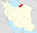 | |
| Counties and cities | ||
| Sights |
| |
| populated places | ||
| Capital | |||||||||||||
|---|---|---|---|---|---|---|---|---|---|---|---|---|---|
| Districts |
| ||||||||||||
This Ramian County location article is a stub. You can help Wikipedia by expanding it. |