
Bagheli-ye Marama Rural District
Persian: دهستان باغلي ماراما | |
|---|---|
 Bagheli-ye Marama Rural District | |
| Coordinates: 37°10′41″N 54°55′53″E / 37.17806°N 54.93139°E[1] | |
| Country | Iran |
| Province | Golestan |
| County | Gonbad-e Kavus |
| District | Central |
| Capital | Bagheli-ye Marama |
| Population (2016)[2] | |
| • Total | 35,771 |
| Time zone | UTC+3:30 (IRST) |
Bagheli-ye Marama Rural District (Persian: دهستان باغلي ماراما) is in the Central District of Gonbad-e Kavus County,[3] Golestan province, Iran. Its capital is the village of Bagheli-ye Marama.[4]
At the National Census of 2006, its population was 33,148 in 7,179 households.[5] There were 34,077 inhabitants in 8,619 households at the following census of 2011.[6] At the most recent census of 2016, the population of the rural district was 35,771 in 9,643 households. The most populous of its 45 villages was Bi Bi Shirvan, with 4,199 people.[2]
References
- ^ OpenStreetMap contributors (13 October 2023). "Bagheli-ye Marama Rural District (Gonbad-e Kavus County)" (Map). OpenStreetMap. Retrieved 13 October 2023.
- ^ a b "Census of the Islamic Republic of Iran, 1395 (2016)". AMAR (in Persian). The Statistical Center of Iran. p. 27. Archived from the original (Excel) on 29 March 2019. Retrieved 19 December 2022.
- ^ Habibi, Hassan (21 June 1369). "Approval of the organization and chain of citizenship of the elements and units of the divisions of Mazandaran province, centered in Sari city". Lamtakam (in Persian). Ministry of Interior, Defense Political Commission of the Government Council. Archived from the original on 14 January 2024. Retrieved 14 January 2024.
- ^ Mousavi, Mirhossein (18 May 1366). "Creation and establishment of 23 rural districts including villages, farms and places in Gonbad-e Kavus County under Mazandaran province". Research Center of the System of Laws of the Islamic Council of the Farabi Library of Mobile Users (in Persian). Ministry of Interior, Board of Ministers. Archived from the original on 25 December 2013. Retrieved 19 November 2023.
- ^ "Census of the Islamic Republic of Iran, 1385 (2006)". AMAR (in Persian). The Statistical Center of Iran. p. 27. Archived from the original (Excel) on 20 September 2011. Retrieved 25 September 2022.
- ^ "Census of the Islamic Republic of Iran, 1390 (2011)". Syracuse University (in Persian). The Statistical Center of Iran. p. 27. Archived from the original (Excel) on 17 January 2023. Retrieved 19 December 2022.
Golestan Province, Iran | ||
|---|---|---|
| Capital | 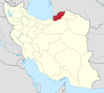 | |
| Counties and cities | ||
| Sights |
| |
| populated places | ||
This Gonbad-e Qabus County location article is a stub. You can help Wikipedia by expanding it. |