
Alentejo
Região do Alentejo | |
|---|---|
 A typical landscape of the Alentejo | |
| Etymology: além-Tejo Portuguese for beyond the Tagus or across the Tagus (note: Lezíria do Tejo is partly of the left margin of the Tagus and partly on the right margin of the Tagus) | |
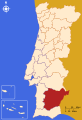
 Location of the Alentejo Region in Portugal | |
| Coordinates: 38°34′00″N 7°54′00″W / 38.5667°N 7.9000°W | |
| Country | |
| Capital | Évora |
| Area | |
| • Total | 31,551.2 km2 (12,182.0 sq mi) |
| Population (2011[1]) | |
| • Total | 758,739 (4th) |
| GDP | |
| • Total | €15.157 billion (2022) |
| • Per capita | €21,741 (2022) |
| Time zone | UTC+0 (WET) |
| • Summer (DST) | UTC+1 (WEST) |
| HDI (2021) | 0.842[4] very high · 5th |
| NUTS | PT15 |
| Geographic detail from Instituto Geográfico Português (2010) | |
Alentejo Region (Portuguese pronunciation: [ɐlẽ'tɛʒu]) is one of the seven NUTS 2 regions of Portugal. It covers all of the historical Alentejo Province and part of the historical Ribatejo and Estremadura provinces.
The greater region is defined within Portugal by the land bordering the left bank of the river Tagus to the North and extending to the South where it borders the Algarve region. The origin of its name, "além" + "Tejo" combined as Alentejo, literally translates to "Beyond-the-Tagus". However, a large part of the subregion Lezíria do Tejo is located on the right bank of the Tagus. The Alentejo is completely located beyond the left margin of the Tagus River.
Its main cities are Évora, Elvas, Portalegre, Beja, Moura, Serpa, Sines and Santarém.
YouTube Encyclopedic
-
1/1Views:8 713
-
No. 1 Climate vulnerable wine region, Alentejo in S Portugal, focuses on true sustainability
Transcription
Subdivisions
The region is subdivided into five intermunicipal communities (NUTS 3 regions):
Demographics
The resident population of the Alentejo stands at around 759,000 (fourth quarter, 2008 – 2 700 less than the fourth quarter of 2007), with 49% men and 51% women. It is the least densely populated region in the country, representing over one third of national territory but only 7.1% of its population. It is also the region with the oldest population, 22.9% being 65 years of age or more (while the national average is 17.5%).
The population is still declining – especially in the east of the Alentejo. Locals are said to migrate from the villages to the towns and from the towns to cities beyond the Alentejo. Some migration into the Alentejo is from Northern Europeans looking to escape their overcrowded regions, though not always permanently, just for sunny holiday retreats.[5] People from China, Brazil, and mostly from (South-)Eastern Europe add to curbing population decline.
Economy
In 2006, the region had an estimated GDP per inhabitant rating of 17,200 EUR.[6] In 2018, the Gross domestic product (GDP) of the region was 13.1 billion euros, accounting for 6.4% of Portugal's economic output. GDP per capita adjusted for purchasing power was 21,700 euros or 72% of the EU27 average in the same year. The GDP per employee was 73% of the EU average.[7]
Maps
-

-

-
 Alentejo Region (NUTS II)
 -
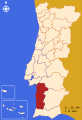
 Lezíria do Tejo (NUTS III)
 -
 Alto Alentejo (NUTS III)
 -
 Baixo Alentejo (NUTS III)
 -
 Alentejo Litoral (NUTS III)
 -
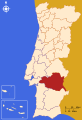 Alentejo Central (NUTS III)


References
- ^ "Censos 2011 Resultados Preliminares 2011". INE.
- ^ "Produto interno bruto (B.1*g) a preços correntes (Base 2016 - €) por Localização geográfica (NUTS - 2013); Anual". www.ine.pt. Retrieved 3 September 2023.
- ^ "Produto interno bruto (B.1*g) por habitante a preços correntes (Base 2016 - €) por Localização geográfica (NUTS - 2013); Anual". www.ine.pt. Retrieved 3 September 2023.
- ^ "Sub-national HDI - Area Database - Global Data Lab". hdi.globaldatalab.org. Retrieved 31 July 2023.
- ^ "Alentejo Portugal, the essence, characteristics and places". Archived from the original on 29 September 2016. Retrieved 25 November 2018.
- ^ "GDP per inhabitant in 2006 ranged from 25% of the EU27 average in Nord-Est in Romania to 336% in Inner London" (PDF). Eurostat. Archived from the original (PDF) on 25 March 2009.
- ^ "Regional GDP per capita ranged from 30% to 263% of the EU average in 2018". Eurostat.
External links
| North Region |
| ||||
|---|---|---|---|---|---|
| Centro Region |
| ||||
| Oeste e Vale do Tejo Region |
| ||||
| Lisbon Region |
| ||||
| Alentejo Region |
| ||||
| Algarve Region |
| ||||
| Autonomous Regions | |||||
All these divisions are further subdivided into municipalities and parishes. | |||||
| International | |
|---|---|
| National | |
| Other | |