
Alto Tâmega | |
|---|---|
 | |
| Coordinates: 41°42′N 7°32′W / 41.700°N 7.533°W | |
| Country | |
| Region | Norte |
| Established | 2014 |
| Seat | Chaves |
| Municipalities | 6 |
| Government | |
| • President | Nuno Vaz Ribeiro |
| Area | |
| • Total | 2,921.91 km2 (1,128.16 sq mi) |
| Population (2011) | |
| • Total | 94,143 |
| • Density | 32/km2 (83/sq mi) |
| Time zone | UTC±00:00 (WET) |
| • Summer (DST) | UTC+01:00 (WEST) |
| Website | cimat |
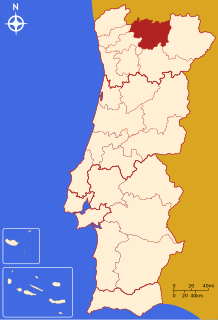
The Comunidade Intermunicipal do Alto Tâmega (Portuguese pronunciation: [ˈaltu ˈtɐmɨɣɐ]) is an administrative division in northern Portugal. It was created in 2014.[1] Since January 2015, Alto Tâmega is also a NUTS3 subregion of Norte Region, that covers the same area as the intermunicipal community.[2] The seat of the intermunicipal community is Chaves. Alto Tâmega comprises the northern part of the Vila Real District. The population in 2011 was 94,143,[3] in an area of 2,921.91 km².[4]
Municipalities
The intermunicipal community of Alto Tâmega consists of 6 municipalities:[5]
| Municipality | Population (2011)[3] | Area (km²)[4] |
|---|---|---|
| Boticas | 5,750 | 321.96 |
| Chaves | 41,243 | 591.23 |
| Montalegre | 10,537 | 805.46 |
| Ribeira de Pena | 6,544 | 217.46 |
| Valpaços | 16,882 | 548.74 |
| Vila Pouca de Aguiar | 13,187 | 437.07 |
| Total | 94,143 | 2,921.91 |
References
- ^ "CIM Alto Tâmega". Archived from the original on 2014-08-19. Retrieved 2014-08-18.
- ^ Adequação dos indicadores à nova organização territorial NUTS III / Entidades Intermunicipais, Instituto Nacional de Estatística, 18 March 2015
- ^ a b Instituto Nacional de Estatística
- ^ a b "Áreas das freguesias, concelhos, distritos e país". Archived from the original on 2018-11-05. Retrieved 2018-11-05.
- ^ "Law nr. 75/2013" (pdf). Diário da República (in Portuguese). Assembly of the Republic (Portugal). Retrieved 18 August 2014.
External links
| North Region |
| ||||
|---|---|---|---|---|---|
| Centro Region |
| ||||
| Lisbon Region |
| ||||
| Alentejo Region |
| ||||
| Algarve Region |
| ||||
| Autonomous Regions | |||||
All these divisions are further subdivided into municipalities and parishes. | |||||