To install click the Add extension button. That's it.

The source code for the WIKI 2 extension is being checked by specialists of the Mozilla Foundation, Google, and Apple. You could also do it yourself at any point in time.

4,5
Kelly Slayton
Congratulations on this excellent venture… what a great idea!
Alexander Grigorievskiy
I use WIKI 2 every day and almost forgot how the original Wikipedia looks like.
Live Statistics
English Articles
Improved in 24 Hours
Added in 24 Hours
Languages
Recent
Show all languages
What we do. Every page goes through several hundred of perfecting techniques; in live mode. Quite the same Wikipedia. Just better.
.
Leo
Newton
Brights
Milds

Terras de Trás-os-Montes

From Wikipedia, the free encyclopedia

Terras de Trás-os-Montes
Coordinates: 41°38′N 6°54′W / 41.63°N 6.90°W / 41.63; -6.90
Country Portugal
RegionNorte
SeatBragança
Municipalities9
Area
 • Total5,543.61 km2 (2,140.40 sq mi)
Population
 (2011)
 • Total117,527
 • Density21/km2 (55/sq mi)
Time zoneUTC±00:00 (WET)
 • Summer (DST)UTC+01:00 (WEST)
Websitecim-ttm.pt

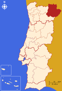
The Comunidade Intermunicipal das Terras de Trás-os-Montes (Portuguese pronunciation: [ˈtɛʁɐʒðɨˌtɾazˈmõtɨʃ]; Mirandese: Tierras de Trás ls Montes; English: Lands of Trás-os-Montes) is an administrative division in northeastern Portugal. Since January 2015, Terras de Trás-os-Montes is also a NUTS3 subregion of Norte Region, that covers the same area as the intermunicipal community.[1] The seat of the intermunicipal community is Bragança.[2] Terras de Trás-os-Montes comprises a large part of the district of Bragança. The population in 2011 was 117,527,[3] in an area of 5,543.61 km².[4]

YouTube Encyclopedic

  • 1/3
    Views:
    820
    1 710
    584
  • Por Terras de Trás os Montes e Alto Douro
  • Terra de Montanha Vila Real
  • Vídeo Cantarelos ambifungi nas Terras de Alfândega da Fé, Trás-os-Montes

Transcription

Municipalities

The intermunicipal community of Terras de Trás-os-Montes consists of 9 municipalities:[5]

Municipality Population (2011)[3] Area (km²)[4]
Alfândega da Fé 5,104 321.95
Bragança 35,341 1173.57
Macedo de Cavaleiros  15,776 699.14
Miranda do Douro 7,482 487.18
Mirandela 23,850 658.96
Mogadouro 9,542 760.65
Vila Flor 6,697 265.81
Vimioso 4,669 481.59
Vinhais 9,066 694.76
Total 117,527 5,543.61

References

  1. ^ Adequação dos indicadores à nova organização territorial NUTS III / Entidades Intermunicipais, Instituto Nacional de Estatística, 18 March 2015
  2. ^ Statutes CIM Terras de Trás-os-Montes Archived 19 August 2014 at the Wayback Machine
  3. ^ a b Instituto Nacional de Estatística
  4. ^ a b Áreas das freguesias, concelhos, distritos e país
  5. ^ "Law nr. 75/2013" (pdf). Diário da República (in Portuguese). Assembly of the Republic (Portugal). Retrieved 18 August 2014.
This page was last edited on 3 April 2023, at 16:03
Basis of this page is in Wikipedia. Text is available under the CC BY-SA 3.0 Unported License. Non-text media are available under their specified licenses. Wikipedia® is a registered trademark of the Wikimedia Foundation, Inc. WIKI 2 is an independent company and has no affiliation with Wikimedia Foundation.