
| Vardar Banovina Вардарска бановина Vardarska banovina | |||||||||||||
|---|---|---|---|---|---|---|---|---|---|---|---|---|---|
| Banovina of Yugoslavia | |||||||||||||
| 1929–1941 | |||||||||||||
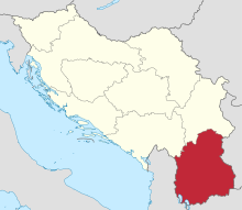 Vardar Banovina (red) within the Kingdom of Yugoslavia (light yellow) | |||||||||||||
| Capital | Skopje | ||||||||||||
| Area | |||||||||||||
• 1931 | 36,672 km2 (14,159 sq mi) | ||||||||||||
| Population | |||||||||||||
• 1921 | 1,323,546 | ||||||||||||
• 1931 | 1,574,243 | ||||||||||||
| History | |||||||||||||
• Established | 1929 | ||||||||||||
• Disestablished | 1941 | ||||||||||||
| |||||||||||||
| Today part of | Kosovo North Macedonia Serbia | ||||||||||||

The Vardar Banovina, or Vardar Banate (Macedonian: Вардарска бановина, romanized: Vardarska banovina; Serbian: Вардарска бановина, romanized: Vardarska Banovina; Albanian: Banovina e Vardarit), was a province (banate) of the Kingdom of Yugoslavia between 1929 and 1941.
YouTube Encyclopedic
-
1/5Views:21 5974 42021 0449 839950
-
North Macedonia during World War II (1941 – 1944)
-
#MariosHistoryTalks EP 12: THE CHRONICLES OF VARDARSKA BANOVINA
-
VARDARSKA IS YOUR NAME SKOPJANS
-
The Bulgarian Occupation of Yugoslavia during World War II (1941 – 1944)
-
World War II in Yugoslav Macedonia | Wikipedia audio article
Transcription
History
It was located in the southernmost part of the country, encompassing the whole of today's North Macedonia, southern parts of Southern and Eastern Serbia and southeastern parts of Kosovo and Serbia. It was named after the Vardar River and its administrative capital was the city of Skopje. According to the 1930 statistics of the Central Press Bureau of the Ministerial Council[1] out of the 9 Yugoslav banovinas, the "Vardarska" banovina was the largest at 38,879 km2 (15,011 sq mi); while its population, was the fourth at 1,386,370 inhabitants. Following the First World War in Vardar Macedonia and the so-called Western Outlands, the local Bulgarian/Macedonian population was not recognized and state-policy of Serbianisation occurred.[2][3][4] It also suffered the worst health problems, especially typhus and smallpox, and required one Institute of Hygiene, 3 health stations and 6 dispensaries and convalescent homes. On the other hand, unlike the banovinas that until the creation of Yugoslavia had belonged to the Austro-Hungarian empire and the lands of Montenegro, it had inherited no debts. According to the 1931 Constitution of the Kingdom of Yugoslavia, the Vardar Banovina was bounded on the north by the boundaries of the Zeta and Morava Banovinas, and on the east, south and west by the State frontiers with Bulgaria, Greece, and Albania. In 1941, the World War II Axis Powers occupied the Vardar Banovina and divided it between Bulgaria, German-occupied Serbia, and Albania under Italy. Following World War II, the southern portion of the region became Socialist Republic of Macedonia while the northern portions were made a part of the Socialist Republic of Serbia, both within the Socialist Federal Republic of Yugoslavia.
Bans of Vardar Banovina
- Živojin Lazić (1929–1932)
- Dobrica Matković (1932–1933)
- Dragoslav Đorđević (1933–1935)
- Ranko Trifunović (1935–1936)
- Dušan Filipović (1936)
- Dragan Paunović (1936–1937)
- Marko Novaković (1937–1939)
- Vladimir Hajduk-Veljković (1939)
- Aleksandar Cvetković (1939)
- Aleksandar Andrejević (1939–1940)
- Žika Rafajlović (1940–1941)
Cities and towns
- Skopje (capital)
- Berovo
- Bitola
- Bosilegrad
- Delčevo
- Debar
- Dragaš
- Gevgelija
- Gjilan
- Gostivar
- Makedonski Brod
- Kaçanik
- Kavadarci
- Kičevo
- Kočani
- Kratovo
- Kriva Palanka
- Kruševo
- Kumanovo
- Lebane
- Leskovac
- Negotino
- Ohrid
- Preševo
- Prilep
- Pristina
- Prizren
- Radoviš
- Resen
- Rostuša
- Strumica
- Surdulica
- Suva Reka
- Sveti Nikola
- Štip
- Tetovo
- Ferizaj
- Valandovo
- Veles
- Vladičin Han
- Vranje
-
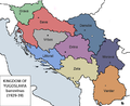 Map of Yugoslav banovinas in 1929 (The Vardar Banovina is #9)
 -
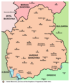 Map of Vardar Banovina
 -
 Sobranie Palace, administrative building of Banovina, today Assembly of the Republic of North Macedonia


See also
References
- ^ Published in the: Central Press Bureau of the Ministerial Council, Belgrade 1930
- ^ Poulton, Hugh (2003). "Macedonians and Albanians as Yugoslavs". In Djokić, Dejan (ed.). Yugoslavism: Histories of a Failed Idea, 1918–1992. C. Hurst & Co. Publishers. p. 123. ISBN 9781850656630.
- ^ Papavizas, George C. (2015). Claiming Macedonia: The Struggle for the Heritage, Territory and Name of the Historic Hellenic Land, 1862-2004. McFarland. pp. 92-93, ISBN 9781476610191.
- ^ Horowitz, Shale (2004). "Structural Sources of Post-Communist Market Reform: Economic Structure, Political Culture, and War". International Studies Quarterly. 48 (4): 765. doi:10.1111/j.0020-8833.2004.00324.x.
External links
Banovinas of the Kingdom of Yugoslavia (1929–1941) | ||||||||||
|---|---|---|---|---|---|---|---|---|---|---|
| 1929–1941 |
|  | ||||||||
| Proposed | ||||||||||
42°00′N 21°25′E / 42.000°N 21.417°E
| International | |
|---|---|
| National | |