
Qir and Karzin County
Persian: شهرستان قیر و کارزین | |
|---|---|
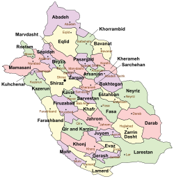 Location of Qir and Karzin County in Fars province (bottom left, green) | |
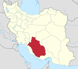 Location of Fars province in Iran | |
| Coordinates: 28°19′40″N 52°58′55″E / 28.32778°N 52.98194°E[1] | |
| Country | |
| Province | Fars |
| Capital | Qir |
| Districts | Central, Efzar |
| Population (2016)[2] | |
| • Total | 71,203 |
| Time zone | UTC+3:30 (IRST) |
| Qir and Karzin County can be found at GEOnet Names Server, at this link, by opening the Advanced Search box, entering "9206548" in the "Unique Feature Id" form, and clicking on "Search Database". | |
Qir and Karzin County (Persian: شهرستان قیر و کارزین)[a] is located in Fars province, Iran. Its capital is the city of Qir.[3]
Demographics
Population
At the time of the 2006 National Census, the county's population was 61,432, in 13,246 households.[4] The following census in 2011 counted 65,045 people, in 16,906 households.[5] At the 2016 census, the county's population was 71,203, in 20,508 households.[2]
Administrative divisions
Administrative divisions
Qir and Karzin County's population history and administrative structure over three consecutive censuses are shown in the following table.
| Administrative Divisions | 2006[4] | 2011[5] | 2016[2] |
|---|---|---|---|
| Central District | 47,392 | 50,747 | 54,377 |
| Fathabad RD | 9,753 | 5,142 | 6,036 |
| Hengam RD | 4,877 | 5,301 | 4,736 |
| Mobarakabad RD | 7,970 | 4,395 | 4,244 |
| Emam Shahr (city)[b] | 5,190 | 5,803 | |
| Karzin (city) | 7,953 | 8,446 | 8,841 |
| Mobarakabad (city) | 4,235 | 4,707 | |
| Qir (city) | 16,839 | 18,038 | 20,010 |
| Efzar District | 14,040 | 14,117 | 14,924 |
| Efzar RD | 8,693 | 7,871 | 8,172 |
| Zakharuiyeh RD | 3,104 | 3,908 | 4,095 |
| Efzar (city) | 2,243 | 2,338 | 2,657 |
| Total | 61,432 | 65,045 | 71,203 |
| RD = Rural District | |||
See also
![]() Media related to Qir and Karzin County at Wikimedia Commons
Media related to Qir and Karzin County at Wikimedia Commons
Notes
References
- ^ OpenStreetMap contributors (28 September 2023). "Qir and Karzin County" (Map). OpenStreetMap. Retrieved 28 September 2023.
- ^ a b c "Census of the Islamic Republic of Iran, 1395 (2016)". AMAR (in Persian). The Statistical Center of Iran. p. 07. Archived from the original (Excel) on 6 April 2022. Retrieved 19 December 2022.
- ^ Aref, Mohammad Reza. "Approval letter regarding the changes and reforms of divisions in Fars province". Islamic Council Research Center (in Persian). Ministry of Interior, Council of Ministers. Archived from the original on 9 October 2021. Retrieved 10 December 2023.
- ^ a b "Census of the Islamic Republic of Iran, 1385 (2006)". AMAR (in Persian). The Statistical Center of Iran. p. 07. Archived from the original (Excel) on 20 September 2011. Retrieved 25 September 2022.
- ^ a b "Census of the Islamic Republic of Iran, 1390 (2011)". Syracuse University (in Persian). The Statistical Center of Iran. p. 07. Archived from the original (Excel) on 16 January 2023. Retrieved 19 December 2022.
- ^ Davodi, Parviz (29 July 2016). "The transformation of the village of Shahrak-e Emam from Fathabad Rural District in the Central District of Qir and Karzin County to Emam Shahr city". Qavanin (in Persian). Ministry of Interior, Political and Defense Commission. Archived from the original on 28 September 2023. Retrieved 28 September 2023.

| Capital | |||||||||||||||||||||||
|---|---|---|---|---|---|---|---|---|---|---|---|---|---|---|---|---|---|---|---|---|---|---|---|
| Districts |
| ||||||||||||||||||||||
This Fars Province location article is a stub. You can help Wikipedia by expanding it. |