
Gerash County
Persian: شهرستان گراش | |
|---|---|
County | |
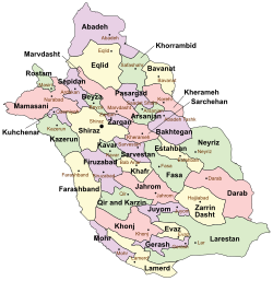 Location of Gerash County in Fars province (bottom center, purple) | |
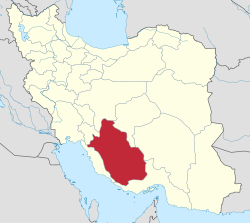 Location of Fars province in Iran | |
| Coordinates: 27°40′N 53°39′E / 27.667°N 53.650°E[1] | |
| Country | |
| Province | Fars |
| Capital | Gerash |
| Districts | Central, Arad |
| Population (2016)[2] | |
| • Total | 53,907 |
| Time zone | UTC+3:30 (IRST) |
Gerash County (Persian: شهرستان گراش) is located in Fars province, Iran. Its capital is the city of Gerash.[3]
In February 2008, Gerash District was separated from Larestan County in the establishment of Gerash County, which was divided into two districts of two rural districts each, with the city of Gerash as its capital and only city at the time.[3]
The National Census in 2011 counted 47,055 people in 12,839 households.[4] At the 2016 census, the county's population was 53,907 in 15,155 households.[2]
Gerash was traditionally part of the region of Irahistan. Gerash's inhabitants are Achomi people.
YouTube Encyclopedic
-
1/2Views:2 784686
-
gerash moharam
-
gerash......turkiye....antalia..ba..yoni5252
Transcription
Administrative divisions
The population history and structural changes of Gerash County's administrative divisions over two consecutive censuses are shown in the following table. The latest census shows two districts, four rural districts, and one city.[2]
After the census of 2016, the village of Arad was elevated to the status of a city.[5]
| Administrative Divisions | 2011[4] | 2016[2] |
|---|---|---|
| Central District | 39,919 | 46,878 |
| Fedagh RD | 5,944 | 8,689 |
| Khalili RD | 3,382 | 3,720 |
| Gerash (city) | 30,593 | 34,469 |
| Arad District | 7,136 | 7,029 |
| Arad RD | 5,767 | 5,443 |
| Sabz Push RD | 1,369 | 1,586 |
| Arad (city)1 | ||
| Total | 47,055 | 53,907 |
| RD: Rural District 1Became a city after the 2016 census[5] | ||
See also
References
- ^ OpenStreetMap contributors (19 September 2023). "Gerash County" (Map). OpenStreetMap. Retrieved 19 September 2023.
- ^ a b c d "Census of the Islamic Republic of Iran, 1395 (2016)". AMAR (in Persian). The Statistical Center of Iran. p. 07. Archived from the original (Excel) on 6 April 2022. Retrieved 19 December 2022.
- ^ a b Rahimi, Mohammad Reza. "The Council of Ministers approved the creation of Gerash city on 11 February 2008". Gerishna (in Persian). Ministry of Interior, Council of Ministers. Archived from the original on 15 November 2023. Retrieved 15 November 2023.
- ^ a b "Census of the Islamic Republic of Iran, 1390 (2011)". Syracuse University (in Persian). The Statistical Center of Iran. p. 07. Archived from the original (Excel) on 16 January 2023. Retrieved 19 December 2022.
- ^ a b "The second municipality of Gerash County was opened in Ard District". Gerishna (in Persian). Archived from the original on 27 August 2018. Retrieved 8 December 2023.

| Capital | |||||||||||||||||
|---|---|---|---|---|---|---|---|---|---|---|---|---|---|---|---|---|---|
| Districts |
| ||||||||||||||||
This Fars Province location article is a stub. You can help Wikipedia by expanding it. |