
Peralta
Azkoien (Basque) | |
|---|---|
| Peralta / Azkoien | |
 Flag 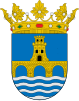 Coat of arms | |
 Peralta Location of Pamplona within Spain / Navarre  Peralta Peralta (Spain) | |
| Coordinates: 42°19′59″N 1°48′00″W / 42.33306°N 1.80000°W | |
| Country | Spain |
| Autonomous Community | Navarre |
| Province | Navarre |
| Merindad | Olite |
| Area | |
| • Total | 88.4 km2 (34.1 sq mi) |
| Population (2018)[1] | |
| • Total | 5,823 |
| • Density | 66/km2 (170/sq mi) |
| Website | www |
Peralta (Basque: Azkoien) is a town and municipality located in the province and autonomous community of Navarre, northern Spain. It is located 59.5 km from Pamplona, and is on the River Arga, a tributary of the Aragon River which itself flows into the Ebro. The population in 2020 was 5951 (INE) inhabitants. Peralta is one of twenty-seven municipalities that make up the Merindad de Olite in the southern part of Navarre.
Symbology
Flag
The flag's description:
It's formed by a cloth of 2/3 proportion, red with the shield of the municipality in the center.
Shield
The Escutcheon of the municipality of Peralta has the following blazon:
A bridge of gold arches on a river, with a tower of the same material
Geography
Location
It's located in the south part of the Foral Community of Navarre. It has an area of 89 km² and has its limit with Falces (North), Marcilla (East), Funes (South) and Azagra (West)
Relief and hydrology
It's located in a zone formed by calize. Its river is River Arga.
Demography

Notable citizens
- Miguel Irigaray Gorría (1850-1903), politician
- Emilio Rodríguez Irazusta (1860-1919), inventor of the National Identity Document, a square is dedicated to him near to the church.
- Santos Jorge, musician and composer of national anthem of Panama.
- Carlos Zalduendo, France rugby league International, former president of the French Rugby League Federation et former president of Toulouse Olympique.
References
- ^ Municipal Register of Spain 2018. National Statistics Institute.
External links
- Ayuntamiento de Peralta
- PERALTA in the Bernardo Estornés Lasa - Auñamendi Encyclopedia (Euskomedia Fundazioa) (in Spanish)
| Authority control databases: National |
|---|
This article about a location in Navarre, Spain, is a stub. You can help Wikipedia by expanding it. |