
Malaga, New Mexico | |
|---|---|
 Malaga | |
| Coordinates: 32°13′22″N 104°04′09″W / 32.22278°N 104.06917°W[1] | |
| Country | United States |
| State | New Mexico |
| County | Eddy |
| Area | |
| • Total | 2.97 sq mi (7.70 km2) |
| • Land | 2.97 sq mi (7.70 km2) |
| • Water | 0.00 sq mi (0.00 km2) |
| Elevation | 3,002 ft (915 m) |
| Population | |
| • Total | 112 |
| • Density | 37.70/sq mi (14.55/km2) |
| Time zone | UTC-7 (Mountain (MST)) |
| • Summer (DST) | UTC-6 (MDT) |
| ZIP code | 88263 |
| Area code | 575 |
| GNIS feature ID | 2584152[1] |
Malaga is a census-designated place and unincorporated community in Eddy County, New Mexico, United States. Its population was 147 as of the 2010 census. Malaga has a post office with ZIP code 88263.[4][5] U.S. Route 285 passes through the community. Formerly known as Kirkwell, Malaga was founded in the 1890s by Swiss immigrants and was named after the Spanish city of Málaga. Italian laborers were recruited to farm the area, and many settled in Malaga.[6]
It is within the Carlsbad Municipal School District,[7] which operates Carlsbad High School.
Malaga is on the Pecos Highway approximately 18 miles southeast of Carlsbad. The Pecos River flows past two miles east of the community.[1]
YouTube Encyclopedic
-
1/3Views:4809 07512 944 085
-
Krishnamurti - Los Alamos New Mexico (1984) - Scientists Talk
-
Carnival Splendor at Málaga's new Cruise Terminal
-
El Camino del Rey [High Quality]
Transcription
Demographics
| Census | Pop. | Note | %± |
|---|---|---|---|
| 2020 | 112 | — | |
| U.S. Decennial Census[8][3] | |||
References
- ^ a b c d U.S. Geological Survey Geographic Names Information System: Malaga, New Mexico
- ^ "ArcGIS REST Services Directory". United States Census Bureau. Retrieved October 12, 2022.
- ^ a b "Census Population API". United States Census Bureau. Retrieved October 12, 2022.
- ^ United States Postal Service (2012). "USPS - Look Up a ZIP Code". Retrieved February 15, 2012.
- ^ "Postmaster Finder - Post Offices by ZIP Code". United States Postal Service. Retrieved March 4, 2014.
- ^ Julyan, Robert (1996). The Place Names of New Mexico. University of New Mexico Press. p. 217. ISBN 0826316891.
- ^ "2020 CENSUS - SCHOOL DISTRICT REFERENCE MAP: Eddy County, NM" (PDF). U.S. Census Bureau. Retrieved June 28, 2022.
- ^ "Census of Population and Housing". Census.gov. Retrieved June 4, 2016.
Municipalities and communities of Eddy County, New Mexico, United States | ||
|---|---|---|
| Cities | 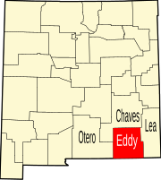 | |
| Villages | ||
| CDPs | ||
| Unincorporated communities | ||
This New Mexico state location article is a stub. You can help Wikipedia by expanding it. |