
Lam Tei 藍地 | ||||||||||||||||||||||
|---|---|---|---|---|---|---|---|---|---|---|---|---|---|---|---|---|---|---|---|---|---|---|
| MTR Light Rail stop | ||||||||||||||||||||||
 Lam Tei stop's Platform | ||||||||||||||||||||||
| General information | ||||||||||||||||||||||
| Location | Lam Tei Tuen Mun District Hong Kong | |||||||||||||||||||||
| Owned by | KCR Corporation | |||||||||||||||||||||
| Operated by | MTR Corporation | |||||||||||||||||||||
| Line(s) | 610 614 615 751 | |||||||||||||||||||||
| Platforms | 2 side platforms | |||||||||||||||||||||
| Tracks | 2 | |||||||||||||||||||||
| Connections | ||||||||||||||||||||||
| Construction | ||||||||||||||||||||||
| Structure type | At-grade | |||||||||||||||||||||
| Accessible | Yes | |||||||||||||||||||||
| Other information | ||||||||||||||||||||||
| Station code | LTE (English code) 350 (Digital code) | |||||||||||||||||||||
| Fare zone | 3 | |||||||||||||||||||||
| History | ||||||||||||||||||||||
| Opened | 18 September 1988 | |||||||||||||||||||||
| Services | ||||||||||||||||||||||
| ||||||||||||||||||||||
| Location | ||||||||||||||||||||||
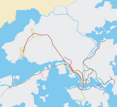 Lam Tei Location within the MTR system | ||||||||||||||||||||||
Lam Tei (Chinese: 藍地) is an at-grade MTR Light Rail stop located at Castle Peak Road in Tuen Mun District, near Lam Tei. It began service on 18 September 1988 and belongs to Zone 3.[1]
YouTube Encyclopedic
-
1/4Views:151 5527 55844215 590
-
self job side effects, It is bad for health. it's side effects is injurious . video in bangla
-
Rejected MTR Lines | The Railways That Never Happened
-
[Slow TV] Motorcycle Ride - Hong Kong - Tin Hau to Lam Tei
-
Hong Kong Holiday
Transcription
References
- ^ "Siu Hong Stop to Lam Tei Stop" (PDF). MTR Corporation. Retrieved 12 August 2021.
External links
 Media related to Lam Tei Stop at Wikimedia Commons
22°25′07″N 113°58′55″E / 22.418553°N 113.981859°E
This MTR- or MTR Corporation-related article is a stub. You can help Wikipedia by expanding it. |