
Krustpils Municipality
Krustpils novads | |
|---|---|
 Flag  Coat of arms | |
 | |
| Country | |
| Formed | 2021 |
| Centre | Jēkabpils (extraterritorially) |
| Government | |
| • Chairman | Kārlis Pabērzs (V) |
| Area | |
| • Total | 811.73 km2 (313.41 sq mi) |
| • Land | 789.49 km2 (304.82 sq mi) |
| • Water | 22.24 km2 (8.59 sq mi) |
| Population (2021)[2] | |
| • Total | 5,461 |
| • Density | 6.7/km2 (17/sq mi) |
| Website | www |
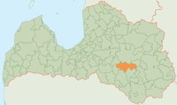
Krustpils Municipality (Latvian: Krustpils novads) is a former municipality in Latgale, Latvia. The municipality was formed in 2009 by merging Atašiene parish, Krustpils parish, Kūkas parish, Mežāre parish, Varieši parish and Vīpe parish. The administrative centre was located in Jēkabpils city, which was not included in the territory of the municipality.
Parts of Teiči Nature Reserve were located in Krustpils Municipality.
On 1 July 2021, Krustpils Municipality ceased to exist and its territory was merged into Jēkabpils Municipality.[3]
YouTube Encyclopedic
-
1/2Views:323516
-
2014 10 18 07 Krustpils Zamok
-
Krustpils Novads Variesu Pagasts Odziena Antuzi Variesi Ugeres Aiviekste Lettland 7.8.2014
Transcription
See also
References
- ^ Error: Unable to display the reference properly. See the documentation for details.
- ^ Error: Unable to display the reference properly. See the documentation for details.
- ^ [1] Law on Administrative Territories and Populated Areas
56°30′N 25°51′E / 56.500°N 25.850°E
| Authority control databases: National |
|---|
This Latgale location article is a stub. You can help Wikipedia by expanding it. |