
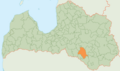
Jēkabpils Municipality
Jēkabpils novads | |
|---|---|
 Flag  Coat of arms | |
 | |
 | |
| Country | |
| Formed | 2009 |
| Reformed | 2021 |
| Centre | Jēkabpils |
| Government | |
| • Council Chair | Aivars Vanags (For Our Own Municipality) |
| Area | |
| • Total | 2,996.11 km2 (1,156.80 sq mi) |
| • Land | 2,904.31 km2 (1,121.36 sq mi) |
| • Water | 91.80 km2 (35.44 sq mi) |
| Population (2023)[2] | |
| • Total | 39,917 |
| • Density | 13/km2 (35/sq mi) |
| Website | www |
Jēkabpils Municipality (Latvian: Jēkabpils novads) is a municipality in Latvia. The municipality was formed in 2009 by merging Ābeļi Parish, Dignāja Parish, Dunava Parish, Kalna Parish, Leimaņi Parish, Rubene Parish and Zasa Parish. During the 2021 Latvian administrative reform, the previous municipality was merged with Aknīste Municipality, Krustpils Municipality, Sala Municipality and Viesīte Municipality. The new municipality now fully corresponds with the area of the former Jēkabpils District.
The administrative centre of the municipality is the city of Jēkabpils. Until 2021, the city was also a separate first-level municipality (republican city) at the same time.
In 2020 the population of the municipality was 4,156.[3]
Symbols (2009–2021)
The coat of arms and the flag used until the 2021 Latvian administrative reform were abolished after the changes in the boundaries of the municipality, with new sketches being unveiled in August 2022.[4] The sketches will need to be approved by the Heraldry Commission of Latvia before use.
-
 Previous flag
 -
 Previous coat of arms
 -
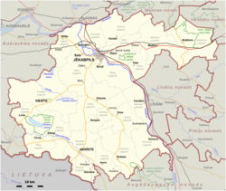
 Boundaries of the municipality from 2009 to 2021


See also
References
- ^ "Reģionu, novadu, pilsētu un pagastu kopējā un sauszemes platība gada sākumā". Central Statistical Bureau of Latvia. Retrieved 18 January 2023.
- ^ "Iedzīvotāju skaits pēc tautības reģionos, pilsētās, novados, pagastos, apkaimēs un blīvi apdzīvotās teritorijās gada sākumā (pēc administratīvi teritoriālās reformas 2021. gadā) 2021 - 2022". Central Statistical Bureau of Latvia. Retrieved 3 October 2023.
- ^ "ISG020. Population number and its change by statistical region, city, town, 21 development centres and county". Central Statistical Bureau of Latvia. 2020-01-01. Retrieved 2021-02-12.
- ^ "Izvēlēta Jēkabpils novada ģerboņa skice | Jekabpils novada pašvaldība". www.jekabpils.lv (in Latvian). Retrieved 2022-09-04.
56°29′44″N 25°52′07″E / 56.49556°N 25.86861°E
| Authority control databases: Geographic |
|---|
This Semigallia location article is a stub. You can help Wikipedia by expanding it. |