
Koma tou Gialou | |
|---|---|
village | |
| Κώμα του Γιαλού (Greek) Kumyalı (Turkish) | |
 | |
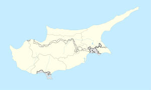 Koma tou Gialou Location in Cyprus | |
| Coordinates: 35°25′37″N 34°7′45″E / 35.42694°N 34.12917°E | |
| Country (de jure) | |
| • District | Famagusta District |
| Country (de facto) | |
| • District | İskele District |
| Government | |
| • Mukhtar | Yaşar Demir |
| Population (2011)[2] | |
| • Total | 686 |
| Time zone | UTC+2 (EET) |
| • Summer (DST) | UTC+3 (EEST) |
Koma tou Gialou (Greek: Κώμα του Γιαλού, Turkish: Kumyalı) is a village in the Famagusta District of Cyprus, located on the Karpas Peninsula. It is under the de facto control of Northern Cyprus, where it is part of the İskele District.
YouTube Encyclopedic
-
1/2Views:768591
-
Famagouste - Famagusta 16 Mars 2013
-
Kantara Castle, Karpass, Agios Philon, Aphendrika...March 2014
Transcription
History
Archaeological excavations around Koma tou Gialou have yielded evidence for the settlement of the area since the Bronze Age. Ruins and tombstones found within the village suggest continuous habitation since at least antiquity.[3]
Geography
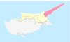
The settlement of Koma tou Gialou extends from the plains near the sea towards a slope, reaching an altitude of 35 metres. It lies 47 km northwest of the city of Famagusta, and 29.5 km northwest of the town of Trikomo. It borders the villages of Galateia, Tavros and Leonarisso. Administratively, it is a part of the Mehmetçik sub-district of the İskele District of Northern Cyprus.[3] Municipal services are provided by the Mehmetçik-Büyükkonuk municipality.[4]
References
- ^ In 1983, the Turkish Republic of Northern Cyprus unilaterally declared independence from the Republic of Cyprus. The de facto state is not recognised by any UN state except Turkey.
- ^ KKTC 2011 Nüfus ve Konut Sayımı [Northern Cyprus 2011 Population and Housing Census] (PDF), Northern Cyprus State Planning Organization, 6 August 2013, archived from the original (PDF) on November 6, 2013
- ^ a b Bağışkan, Tuncer; Altan, Zekai (2023). Karpaz'ın Geçmişine Yolculuk. Nicosia: Söylem Printing. p. 400. ISBN 9789963910021.
- ^ "Kumyalı Köyü". Mehmetçik Büyükkonuk Municipality. Retrieved 17 December 2023.

| International | |
|---|---|
| National | |
This Cyprus location article is a stub. You can help Wikipedia by expanding it. |