
Kilindi
Wilaya ya Kilindi (Swahili) | |
|---|---|
| Wilaya ya Kilindi, Mkoa wa Tanga | |
| Nickname: The royal crown of Tanga | |
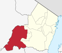 Kilindi District in Tanga Region 2022 | |
| Coordinates: 5°33′54.72″S 37°33′12.6″E / 5.5652000°S 37.553500°E | |
| Country | |
| Region | Tanga Region |
| District | 2002 |
| Capital | Songe |
| Area | |
| • Total | 6,444 km2 (2,488 sq mi) |
| • Rank | 2/11 |
| Population (2022) | |
| • Total | 398,391 |
| • Density | 62/km2 (160/sq mi) |
| Demonym | Kilindian |
| Ethnic groups | |
| • Settler | Swahili |
| • Native | Nguu & Zigua |
Kilindi is one of eleven administrative districts of Tanga Region in Tanzania. The District covers an area of 6,444 km2 (2,488 sq mi).[1] It is bordered to the east by the Handeni District and Handeni Town Council, to the south west by the Kiteto District and north west by the Simanjiro District of Manyara Region. Kilindi District is bordered to the south by Gairo District and Kilosa District of Morogoro Region. The district created from Handeni District in 2002. The district seat (capital) is the town of Songe. According to the 2022 census, the district has a total population of 398,391.[2][3]
Etymology
Kilindi district is named after the Kilindi Dynasty that ruled over western Tanga in the 18-20th century.
Administrative subdivisions
As of 2012, Kilindi District was administratively divided into 21 wards.[4]
Wards
References
- ^ "Tanzania: Northern Zone(Districts and Wards) - Population Statistics, Charts and Map".
- ^ "2012 Population and Housing Census General Report" (PDF). Government of Tanzania. Retrieved 2022-06-02.
- ^ "Kilindi (District, Tanzania) - Population Statistics, Charts, Map and Location". www.citypopulation.de. Retrieved 2024-02-11.
- ^ "2012 Population and Housing Census" (PDF). Development Partners Group Tanzania. Archived from the original (PDF) on 29 March 2018. Retrieved 7 August 2019.
This Tanga Region location article is a stub. You can help Wikipedia by expanding it. |