
Edens
Iens | |
|---|---|
Village | |
 Village view | |
 Flag  Coat of arms | |
 Location in the former Littenseradiel municipality | |
 Edens Location in the Netherlands  Edens Edens (Netherlands) | |
| Coordinates: 53°7′20″N 5°36′50″E / 53.12222°N 5.61389°E | |
| Country | |
| Province | |
| Municipality | |
| Area | |
| • Total | 3.12 km2 (1.20 sq mi) |
| Elevation | 0.4 m (1.3 ft) |
| Population (2021)[1] | |
| • Total | 50 |
| • Density | 16/km2 (42/sq mi) |
| Postal code | 8733[1] |
| Dialing code | 0515 |
Iens (Dutch: Edens) is a small village in Súdwest-Fryslân in the province Friesland of the Netherlands with a population of around 32 in January 2017.[3]
YouTube Encyclopedic
-
1/3Views:4752 0201 314
-
SPOT IENS CCSA
-
Les erreurs alimentaires des végéta*iens
-
NCLEX-RN Exam Prep Study Group for IENs
Transcription
History
The village was first mentioned in the 13th century as Ederinghe, and means "settlement of the people of Ede (person)".[4] Iens is a terp (artificial living hill) village.[5]
Before 2018, the village was part of the Littenseradiel municipality and before 1984 it belonged to Hennaarderadeel municipality. It changed its official name from Edens to Iens in 1991.[6]
Iens has a church dating from the thirteenth century. It was renewed in 1874, and the tower dates was restored in 1852. The choir was extended and includes the 1783 water well which used to be located outside the church.[5] The Edensermolen, a smock mill built in 1847 for drainage has been restored and is held in reserve for emergencies.[6] Iens was home to 48 people in 1840.[7]
Gallery
-
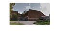
Farm in Iens
-

Windmill De Edensermolen

References
- ^ a b c "Kerncijfers wijken en buurten 2021". Central Bureau of Statistics. Retrieved 6 April 2022.
two entries
- ^ "Postcodetool for 8733EM". Actueel Hoogtebestand Nederland (in Dutch). Het Waterschapshuis. Retrieved 6 April 2022.
- ^ Aantal inwoners per dorp Archived 2017-04-21 at the Wayback Machine - Littenseradiel
- ^ "Iens - (geografische naam)". Etymologiebank (in Dutch). Retrieved 6 April 2022.
- ^ a b "Iens". Friesland Wonderland (in Dutch). Retrieved 6 April 2022.
- ^ a b "Littenseradiel website". Littenseradiel.nl. Archived from the original on 31 October 2016. Retrieved 2 November 2017.
- ^ "Iens". Plaatsengids (in Dutch). Retrieved 6 April 2022.
External links
![]() Media related to Iens at Wikimedia Commons
Media related to Iens at Wikimedia Commons
This Friesland location article is a stub. You can help Wikipedia by expanding it. |