
Blauwhuis
Blauhús | |
|---|---|
Village | |
 St Vitus' Church | |
 Flag  Coat of arms | |
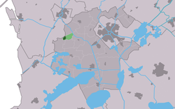 Location in the former Wymbritseradiel municipality | |
 Blauwhuis Location in the Netherlands  Blauwhuis Blauwhuis (Netherlands) | |
| Coordinates: 53°1′21″N 5°31′56″E / 53.02250°N 5.53222°E | |
| Country | |
| Province | |
| Municipality | |
| Area | |
| • Total | 1.73 km2 (0.67 sq mi) |
| Elevation | −0.1 m (−0.3 ft) |
| Population (2021)[1] | |
| • Total | 605 |
| • Density | 350/km2 (910/sq mi) |
| Postal code | 8615[1] |
| Dialing code | 0515 |
Blauwhuis (West Frisian: Blauhús) is a village in Súdwest-Fryslân municipality in the province of Friesland, the Netherlands. It had a population of around 585 in January 2017.[3]
History
The village was first mentioned in 1718 as 't Blauw Huys, and means "blue houses" after the tiles of the polder office who had been responsible for the 1622 poldering of the lake Sensmeer.[4][5] In 1651, a priest was in charge of the polder house and started to invite other Catholics to the area, and developed into a Catholic enclave during the 18th century.[5][6]
Blauwhuis was home to 151 people in 1840.[7] The Catholic St Vitus Church was built between 1868 and 1871 and was designed by Pierre Cuypers.[5] The church replaced a clandestine church in a barn.[7] In 1950, it was awarded village status.[5] Before 2011, the village was part of the Wymbritseradiel municipality.[7]
Gallery
-
 Pub in Blauwhuis
 -
 Carriage house
 -
 Welcome to Blauwhuis
 -
![Horse statue by Maria van Everdingen [nl]](/wikipedia/commons/thumb/f/ff/20180817_Fole_fan_Frysk_hynder1_door_Maria_van_Everdingen.jpg/120px-20180817_Fole_fan_Frysk_hynder1_door_Maria_van_Everdingen.jpg) Horse statue by Maria van Everdingen
Horse statue by Maria van Everdingen
References
- ^ a b c "Kerncijfers wijken en buurten 2021". Central Bureau of Statistics. Retrieved 5 April 2022.
- ^ "Postcodetool for 8615LB". Actueel Hoogtebestand Nederland (in Dutch). Het Waterschapshuis. Retrieved 5 April 2022.
- ^ Kerncijfers wijken en buurten 2017 - CBS Statline
- ^ "Blauwhuis - (geografische naam)". Etymologiebank (in Dutch). Retrieved 5 April 2022.
- ^ a b c d Ronald Stenvert & Sabine Broekhoven (2000). "Blauwhuis" (in Dutch). Zwolle: Waanders. ISBN 90 400 9476 4. Retrieved 5 April 2022.
- ^ "Blauwhuis". Friesland Wonderland (in Dutch). Retrieved 5 April 2022.
- ^ a b c "Blauwhuis". Plaatsengids (in Dutch). Retrieved 5 April 2022.
This Friesland location article is a stub. You can help Wikipedia by expanding it. |