
| Hotan River | |
|---|---|
 The Hotan River is formed by the union of the White Jade and Black Jade Rivers in northern China.[1] | |
| Native name | |
| Physical characteristics | |
| Source | Karakash River, White Jade River |
| • coordinates | 38°05′N 80°34′E / 38.08°N 80.56°E |
| Mouth | Tarim River |
• coordinates | 40°28′43″N 80°56′39″E / 40.478479°N 80.944169°E |
| Basin features | |
| Progression | Tarim→ Taitema Lake |
| Hotan River | |||||||||
|---|---|---|---|---|---|---|---|---|---|
| Uyghur name | |||||||||
| Uyghur | خوتەن دەرياسى | ||||||||
| |||||||||
| Chinese name | |||||||||
| Chinese | 和田河 | ||||||||
| |||||||||
| Old name | |||||||||
| Traditional Chinese | 和闐河 | ||||||||
| Simplified Chinese | 和阗河 | ||||||||
| |||||||||
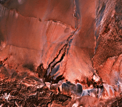
The Hotan River (also known as the Khotan River or the Ho-t'ien River) is formed by the union of the White Jade (Yurungkash) and Karakash (Black Jade) Rivers, which flow north from the Kunlun Mountains into the Taklamakan Desert in northern China. The two rivers unite towards the middle of the desert, some 145 kilometres (90 mi) north of the town of Hotan. The river then flows 290 kilometres (180 mi) northwards across the desert and empties itself into the Tarim River.[2] Because the river is fed by melting snow from the mountains, it only carries water during the summer and is dry the rest of the year. Prior to construction of the Tarim Desert Highway in 1995, the Hotan river bed provided the only transportation system across the Tarim Basin.[3]

YouTube Encyclopedic
-
1/1Views:6 315
-
Пустыня Такламакан. Древний район Хотан.
Transcription
Wells
In the mid-20th century, wells along the course of the river included (south to north): Hsüeh-erh-ch'i-k'o-ma, Chi-la-mu-yeh-te-tao, Ai-k'o-t'i-ken, Ch'i-erh-ko-han-t'u-mu-shu-k'o, A-ya-k'o-wu-ssu-tan, Man-ta-t'u-mu-shu-k'o, Lo-tsa-pai-t'u-mu-shu-k'o, Yeh-ma-la-k'o-tao, Po-lo-ch'u-shih-kan, Hsi-t'i-pa-ku-t'an and Ya-erh-te-ku-tzu.[4]
References
- ^ http://www.travel-silkroad.com/english/dongfanwenming/history/htsj/gyzkc.htm
- ^ "Khotan-Darya". 1911 Encyclopædia Britannica.
- ^ The Southwest Taklimakan Desert Archived 2014-04-07 at the Wayback Machine from NASA's Geomorphology from Space Archived 2006-09-29 at the Wayback Machine. Retrieved March 29, 2014.
- ^ "NJ 44 Ho-tien". Washington, D. C.: U.S. Army Topographic Command. 1971 – via Perry–Castañeda Library Map Collection.
Hsüeh-erh-ch'i-k'o-ma (well){...}Chi-la-mu-yeh-te-tao (well){...}Ai-k'o-t'i-ken (well){...}Ch'i-erh-ko-han-t'u-mu-shu-k'o (well){...}A-ya-k'o-wu-ssu-tan (well){...}Man-ta-t'u-mu-shu-k'o (well){...}Lo-tsa-pai-t'u-mu-shu-k'o (well){...}Yeh-ma-la-k'o-tao (well){...}Po-lo-ch'u-shih-kan (well){...}Hsi-t'i-pa-ku-t'an (well){...}Ya-erh-te-ku-tzu (well)
Notes
- ^ From map: "DELINEATION OF INTERNATIONAL BOUNDARIES MUST NOT BE CONSIDERED AUTHORITATIVE".
This Xinjiang location article is a stub. You can help Wikipedia by expanding it. |
This article related to a river in China is a stub. You can help Wikipedia by expanding it. |