
Haripur District
ضلع ہری پور هريپور ولسوالۍ | |
|---|---|
  Top: Khanpur Dam Bottom: Buddhist remains at Badalpur | |
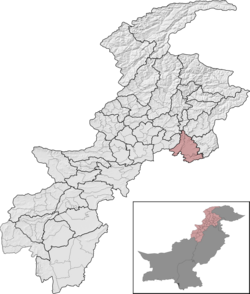 Haripur District (red) in Khyber Pakhtunkhwa | |
| Country | Pakistan |
| Province | Khyber Pakhtunkhwa |
| Division | Hazara |
| Headquarters | Haripur |
| Government | |
| • Type | District Administration |
| • Deputy Commissioner | N/A |
| • District Police Officer | N/A |
| • District Health Officer | N/A |
| Area | |
| • Total | 1,725 km2 (666 sq mi) |
| Population (2023)[1] | |
| • Total | 1,174,783 |
| • Density | 680/km2 (1,800/sq mi) |
| Time zone | UTC+5 (PST) |
| Number of Tehsils | 3 |
| languages | Hindko • Pashto • Urdu |
| Website | haripur |
Haripur District (Hindko, Urdu: ضلع ہری پور) is a district in the Hazara Division of Khyber Pakhtunkhwa, Pakistan.
Before obtaining the status of a district in 1991, Haripur was a tehsil of Abbottabad District.[2][3]: 5 Its headquarters are the city of Haripur.
Geography

Geographically, the district borders the Abbottabad District to the northeast, Mansehra District to the northeast, the Punjab to the southeast, the Buner to the northwest, and Swabi to the west. The federal capital of Islamabad is adjacent to the district in the south.
Demographics
| Year | Pop. | ±% p.a. |
|---|---|---|
| 1951 | 252,168 | — |
| 1961 | 273,507 | +0.82% |
| 1972 | 417,561 | +3.92% |
| 1981 | 479,031 | +1.54% |
| 1998 | 692,228 | +2.19% |
| 2017 | 1,001,515 | +1.96% |
| 2023 | 1,174,783 | +2.70% |
| Sources:[4] | ||
At the time of the 2017 census, the district had 161,839 households and a population of 1,003,031. Haripur had a sex ratio of 1010 females per 1000 males. 133,100 (13.29%) lived in urban areas. 24.91% of the population were under 10 years of age. 1,193 (0.12%) people in the district were from religious minorities, mainly Christians.[1]
At the time of the 2017 census, 80.84% of the population spoke Hindko, 11.84% spoke Pashto, 1.83% Urdu, and 1.51% Punjabi as their first language. 2.09% of the population spoke languages classified as 'Other', mainly Kohistani.
The literacy rate in the Haripur district is 72.21%, substantially higher than the literacy rate in the region of Hazara, which is 35.2%. The female literacy rate is only 61.08% compared to male literacy of 83.07%, and the urban literacy rate of 82.34% is higher than the rural rate of 70.59%.
Administration
The district of Haripur was a tehsil (sub-division) of the Abbottabad District until 1992. After that, it received the status of an independent district.[3] Currently, Haripur District is divided into three Tehsils:
- Haripur Tehsil (Urdu: تحصیل ہری پور) (Pashto: هريپور تحصیل)[5]
- Khanpur Tehsil (Urdu: تحصیل خانپور) (Pashto: خانپور تحصیل)
- Ghazi Tehsil (Urdu: تحصیل غازی) (Pashto: غازي تحصیل)[6][5]
Provincial Assembly
| Member of Provincial Assembly | Party Affiliation | Constituency | Year |
|---|---|---|---|
| Akbar Ayub Khan | Pakistan Tehreek-e-Insaf | PK-40 Haripur-I | 2024 |
| Arshad Ayub Khan | Pakistan Tehreek-e-Insaf | PK-41 Haripur-II | 2024 |
| Umer Ayub Khan | Pakistan Tehreek-e-Insaf | NA-18 Haripur | 2024 |
| Adeel Iqbal | Pakistan Tehreek-e-Insaf | PK-42 Haripur-III | 2024 |
Education
Haripur District has two government-funded postgraduate colleges, providing higher-level education, as well as four-degree colleges for women. The Haripur University was established in 2012, which was initially a Haripur campus (established in March 2008) of the Hazara University .The campus was upgraded to a full-fledged University of Haripur (UoH) in 2012 by the Government of Khyber Pakhtunkhwa.[7][8]
In addition, the project of the Pak-Austria Fachhochschule Institute of Applied Sciences and Technology has also been functioning and is providing higher education since 2017 in village Mang at the main Khanpur Road in Haripur.
See also
References
- ^ a b "District Wise Population / Tables (Census - 2017) (see page 2 of 13 for Haripur District)" (PDF). Pakistan Bureau of Statistics website. Archived from the original (PDF) on 15 June 2020. Retrieved 30 October 2023.
- ^ "Haripur District population per 2017 census of Pakistan". Citypopulation.de website. Archived from the original on 29 April 2020. Retrieved 29 October 2023.
- ^ a b 1998 District Census report of Haripur. Census publication. Vol. 91. Islamabad: Population Census Organization, Statistics Division, Government of Pakistan. 2000.
- ^ "Population by administrative units 1951-1998" (PDF). Pakistan Bureau of Statistics.
- ^ a b "Tehsils & Unions in the District of Haripur". National Reconstruction Bureau (NRB), Government of Pakistan website. Archived from the original on 9 February 2012. Retrieved 29 October 2023.
- ^ "District Haripur". Local Government, Elections and Rural Development Department. Retrieved 30 April 2023.
- ^ "Approval of upgrading sub-campus of the Hazara University in Haripur to university level". Dawn newspaper. 23 March 2012. Retrieved 30 October 2023.
- ^ "University of Haripur". www.uoh.edu.pk.
Further reading
- Waldemar Heckel, Lawrence A. Tritle, ed (2009). Alexander the Great: A New History. Wiley-Blackwell. pp. 47–48. ISBN 978-1-4051-3082-0. [1]
- Tripathi (1999). History of Ancient India. Motilal Banarsidass Publ.. pp. 118–121. ISBN 978-81-208-0018-2. [2]
- Narain, pp. 155–165
- Curtius in McCrindle, Op cit, p 192, J. W. McCrindle; History of Punjab, Vol I, 1997, p 229, Punajbi University, Patiala, (Editors): Fauja Singh, L. M. Joshi; Kambojas Through the Ages, 2005, p 134, Kirpal Singh.

| International | |
|---|---|
| National | |
33°44′N 72°35′E / 33.733°N 72.583°E