
| Cooper Cooper's | |
|---|---|
 Cooper Creek Crossing at Innamincka, South Australia | |
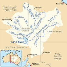 Map of the Lake Eyre Basin showing Cooper Creek | |
| Etymology | Charles Cooper[1] |
| Location | |
| Country | Australia |
| State | Queensland, South Australia |
| Region | Channel Country |
| City | Innamincka |
| Physical characteristics | |
| Source | |
| • elevation | 140 m (460 ft) |
| Mouth | |
• location | Lake Eyre, Far North, South Australia |
• coordinates | 28°23′S 137°41′E / 28.383°S 137.683°E |
• elevation | 5 m (16 ft) |
| Length | 1,300 km (810 mi) |
| Basin features | |
| River system | Lake Eyre basin |
| Tributaries | |
| • left | Thomson River, Wilson River |
| • right | Barcoo River |
| [2] | |
The Cooper Creek (formerly Cooper's Creek) is a river in the Australian states of Queensland and South Australia. It was the site of the death of the explorers Burke and Wills in 1861. It is sometimes known as the Barcoo River from one of its tributaries and is one of three major Queensland river systems that flow into the Lake Eyre basin. The flow of the creek depends on monsoonal rains falling months earlier and many hundreds of kilometres away in eastern Queensland.[1] It is 1,300 kilometres (810 mi) in length.[1]
YouTube Encyclopedic
-
1/5Views:5 3511 8843 3501 415710
-
Cooper Creek Campground overnight car camping with 4 kids
-
Dirt biking at Cooper Creek Park Deepwater MO 2017 11 03 c1
-
Backpacking Up Close at Cooper's Creek
-
26th May Montecollina Bore to The Cooper Creek
-
Dirt bike riding at Cooper Creek Motorcycle and ATV area Deepwater MO 10
Transcription
History

Aboriginal Australians have inhabited the area for over 20,000 years, with over 25 tribal groups living in the Channel Country area alone. A vast trade network had been established running from north to south, with goods such as ochre sent north, while shells and pituri moved south. Birdsville was once a major meeting place for conducting ceremonies and trade.[3]
Charles Sturt named the river in 1845 after Charles Cooper, the Chief Justice of South Australia. It was along Cooper Creek that the explorers Burke and Wills died in 1861. John King survived the expedition with the assistance of friendly Aboriginal people. Only ten years after the explorers' deaths, homesteads were being established on the watercourse. A station at Innamincka was the first permanent settlement in the area.[1]
By 1880 the reliable water source had attracted more settlers to the point where the whole area was taken up and stocked with cattle. This led to the displacement of local people from their traditional lands. By 1900 the population had reduced to 30 survivors, just 10% of the original number, as influenza and measles took their toll.[1]
The waterway does not experience regular seasonal floods.[4] Being ephemeral the creek is still prone to occasional flooding, in 1940 a vast area surrounding the Cooper was underwater with the creek being measured at over 27 miles (43 km) wide in places.[5]
Course
It rises west of the Great Dividing Range on low ground as two central Queensland rivers, the Thomson between Longreach and Charters Towers, and the Barcoo in the area east of Tambo. This is believed to be the only instance in the world where two rivers flow into a creek.
Cooper Creek spreads out into a vast area of anastomosing ephemeral channels, making its way roughly south into the far south-west corner of Queensland before turning due west into South Australia towards Lake Eyre. In most years, it is absorbed into the earth, goes to fill channels and the many permanent waterholes and lakes such as Lake Yamma Yamma, or simply evaporates without reaching Lake Eyre.
In very wet years, however, it manages to flood the entire Channel Country and reaches Lake Eyre after flowing through the dry areas of Strzelecki Desert, Sturt Stony Desert and the Tirari Desert.[6] Studies have clearly shown that, although with a mean annual flow of around 2.3 cubic kilometres (0.55 cu mi) (ranging at Barcoo from an estimated 0.02 km3 or 16,000 acre⋅ft in 1902 to an estimated 12 km3 or 2.9 cu mi in 1950) the Cooper carries twice as much runoff as the Diamantina and three times as much as the Georgina, over the past ten thousand years it has reached Lake Eyre much less frequently than those rivers. This is because much more water is absorbed along its course than with the Diamantina or Georgina, but may also be because of centennial or multicentennial wet and dry cycles in those basins causing them to regularly reach the lake during wet periods (there is some evidence from terraces around Lake Eyre that this occurred during the Medieval Warm Period). During a flooding event the river upstream of Windorah may be as wide as 40 kilometres (25 mi).[6]
Land use
Most of the basin of the Cooper is used for sheep and cattle grazing on natural grasslands: although the extreme east of the basin is relatively wet with averages of over 500 mm (20 inches) at Blackall, the rainfall is much too erratic for cropping. The soils are mainly Vertisols or Vertic Torrifluvents and are quite fertile, though generally heavy in texture with a strong tendency to crack due to the erratic rainfall.
See also
- Cooper Creek catfish
- Cooper Floodplain below Windorah
- List of rivers of Australia
- Yapunyah waterhole
References
- ^ a b c d e Reardon, Mitch (1995). The Australian Geographic Book of Corner Country. Terrey Hills, New South Wales: Australian Geographic. pp. 91–108. ISBN 1-86276-012-8.
- ^ "Map of Cooper Creek". Bonzle Digital of Australia. Retrieved 25 March 2017.
- ^ "Georgina-Diamantina Catchment Strategic Plan" (PDF). Natural Heritage Trust. 1 October 2000. Archived from the original (PDF) on 29 October 2013. Retrieved 26 October 2013.
- ^ Mabbutt, J. A. (2012). "Landforms of the Australian Desert". In El-Baz, F. (ed.). Deserts and arid lands: Volume 1 of Remote Sensing of Earth Resources and Environment. Springer Science & Business Media. p. 80. ISBN 978-9400960800. Retrieved 27 September 2015.
- ^ "Floods only bar to rats". Recorder. Port Pirie, South Australia: National Library of Australia. 19 March 1940. p. 1. Retrieved 26 October 2013.
- ^ a b "Flood Warning System for the Cooper Creek Catchment". Bureau of Meteorology (Australia). Retrieved 19 October 2009.
External links
- Aerial Video of the Cooper Creek at Innamincka
- Australian Society for Limnology
- Primary Industries and Resources SA - Cooper and Diamantina
- Floods of Lake Eyre
- Gerald Nanson Channel Country
- Department of the Environment and Heritage
Rivers of Queensland | |||||||||||||||
|---|---|---|---|---|---|---|---|---|---|---|---|---|---|---|---|
| |||||||||||||||
| |||||||||||||||
| |||||||||||||||
| |||||||||||||||
| |||||||||||||||