
| Warburton Warburton Creek | |
|---|---|
 | |
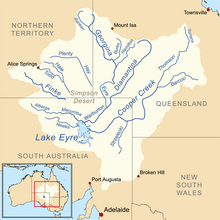 Map of the Lake Eyre Basin showing Warburton River | |
| Location | |
| Country | Australia |
| State | South Australia |
| Physical characteristics | |
| Source | Goyder Lagoon |
| • elevation | 24 m (79 ft) |
| Mouth | Lake Eyre |
• coordinates | 27°54′36″S 137°10′58″E / 27.91000°S 137.18278°E |
• elevation | −15 m (−49 ft) |
| Length | 412 km (256 mi) |
| Basin features | |
| River system | Lake Eyre Basin |
| Tributaries | |
| • right | Macumba River |
| [1] | |
The Warburton River (or Warburton Creek) is a freshwater stream in the far north of South Australia that flows southwest and discharges into the eastern side of Lake Eyre. It is one of the state's largest rivers, and is part of the Lake Eyre Basin. It runs along the eastern side of the Simpson Desert, and drains water from Eyre Creek, the Diamantina and Georgina rivers from Goyder Lagoon, carrying it into Lake Eyre during its infrequent floods.
The river passes through a number of permanent and semi-permanent waterholes, including the Poothapootha, Emu Bone, Wurdoopoothanie waterholes and Kalawarranna soakage.
There are seven tributaries of the river; Warburton Creek, Macumba River, Officer Creek, Kallakoopah Creek, Yelpawaralinna Creek and Derwent Creek.
YouTube Encyclopedic
-
1/3Views:7 0665 2681 431
-
Warburton, VIC | A winter's day exploring Mt Donna Buang and Warburton Redwoods
-
Warburton Crossing K1 Line QAA Line Simpson Desert
-
Melbourne's beautiful rivers, creeks and reservoirs
Transcription
See also
References
- ^ "Map of Warburton River, SA". Bonzle Digital Atlas of Australia. Retrieved 23 March 2017.