
Touffreville-la-Corbeline | |
|---|---|
 Coat of arms | |
Location of Touffreville-la-Corbeline  | |
 Touffreville-la-Corbeline  Touffreville-la-Corbeline | |
| Coordinates: 49°34′54″N 0°45′51″E / 49.5817°N 0.7642°E | |
| Country | France |
| Region | Normandy |
| Department | Seine-Maritime |
| Arrondissement | Rouen |
| Canton | Yvetot |
| Government | |
| • Mayor (2020–2026) | Gilles Cottey[1] |
| Area 1 | 12.59 km2 (4.86 sq mi) |
| Population (Jan. 2020)[2] | 835 |
| • Density | 66/km2 (170/sq mi) |
| Time zone | UTC+01:00 (CET) |
| • Summer (DST) | UTC+02:00 (CEST) |
| INSEE/Postal code | 76702 /76190 |
| Elevation | 29–142 m (95–466 ft) (avg. 145 m or 476 ft) |
| 1 French Land Register data, which excludes lakes, ponds, glaciers > 1 km2 (0.386 sq mi or 247 acres) and river estuaries. | |
Touffreville-la-Corbeline is a commune in the Seine-Maritime department in the Normandy region in northern France.
YouTube Encyclopedic
-
1/1Views:1 947
-
soirée réveillon célibataires 2008 sur Paris Ile de France avec CELI . LOISIRS
Transcription
Geography
A farming village situated in the Pays de Caux, some 22 miles (35 km) northwest of Rouen at the junction of the D104, D37 and the D131 roads.
Heraldry
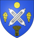 |
The arms of Touffreville-la-Corbeline are blazoned : Azure, 2 weavers shuttles in saltire argent between a bezant, 2 oak leaves and a garb [of wheat] Or.
|
Population
| Year | Pop. | ±% p.a. |
|---|---|---|
| 1968 | 586 | — |
| 1975 | 614 | +0.67% |
| 1982 | 664 | +1.12% |
| 1990 | 789 | +2.18% |
| 1999 | 804 | +0.21% |
| 2007 | 777 | −0.43% |
| 2012 | 795 | +0.46% |
| 2017 | 826 | +0.77% |
| Source: INSEE[3] | ||
Places of interest
- The church of St. Martin, dating from the twelfth century.
- Remains of a feudal castle at Bois-de-la-Salle.
- Two chateaux, at Verbosc and Bourg-Naudin.
- A chapel at Verbosc.
See also
References
- ^ Liste des maires du département de la Seine-Maritime, 10 August 2020
- ^ "Populations légales 2020". The National Institute of Statistics and Economic Studies. 29 December 2022.
- ^ Population en historique depuis 1968, INSEE
Wikimedia Commons has media related to Touffreville-la-Corbeline.
| Authority control databases: National |
|---|