
Theuville-aux-Maillots | |
|---|---|
 The town hall | |
 Coat of arms | |
Location of Theuville-aux-Maillots  | |
 Theuville-aux-Maillots  Theuville-aux-Maillots | |
| Coordinates: 49°45′58″N 0°32′42″E / 49.7661°N 0.545°E | |
| Country | France |
| Region | Normandy |
| Department | Seine-Maritime |
| Arrondissement | Le Havre |
| Canton | Fécamp |
| Intercommunality | CA Fécamp Caux Littoral |
| Government | |
| • Mayor (2020–2026) | Thérèse Affagard[1] |
| Area 1 | 7.24 km2 (2.80 sq mi) |
| Population (Jan. 2020)[2] | 535 |
| • Density | 74/km2 (190/sq mi) |
| Time zone | UTC+01:00 (CET) |
| • Summer (DST) | UTC+02:00 (CEST) |
| INSEE/Postal code | 76686 /76540 |
| Elevation | 58–132 m (190–433 ft) (avg. 112 m or 367 ft) |
| 1 French Land Register data, which excludes lakes, ponds, glaciers > 1 km2 (0.386 sq mi or 247 acres) and river estuaries. | |
Theuville-aux-Maillots (French pronunciation: [tøvil o majo]) is a commune in the Seine-Maritime department in the Normandy region in north-western France.
Geography
A farming village in the Pays de Caux, situated some 31 miles (50 km) northeast of Le Havre, at the junction of the D 5 and D 69 roads.
Heraldry
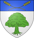 |
The arms of Theuville-aux-Maillots are blazoned : Argent, an oak eradicated vert, and on a chief azure, 2 stalks of wheat in saltire Or.
|
Population
|
| ||||||||||||||||||||||||||||||||||||||||||||||||||||||||||||||||||||||||||||||||||||||||||||||||||||||||||||||||||
| Source: EHESS[3] and INSEE (1968-2017)[4] | |||||||||||||||||||||||||||||||||||||||||||||||||||||||||||||||||||||||||||||||||||||||||||||||||||||||||||||||||||
Places of interest
- The church of St. Maclou and St. Eutrope, dating from the eighteenth century.
- A chateau dating from the sixteenth century.
See also
References
- ^ "Répertoire national des élus: les maires". data.gouv.fr, Plateforme ouverte des données publiques françaises (in French). 2 December 2020.
- ^ "Populations légales 2020". The National Institute of Statistics and Economic Studies. 29 December 2022.
- ^ Des villages de Cassini aux communes d'aujourd'hui: Commune data sheet Theuville-aux-Maillots, EHESS (in French).
- ^ Population en historique depuis 1968, INSEE
Wikimedia Commons has media related to Theuville-aux-Maillots.
| Authority control databases: National |
|---|