
Argueil | |
|---|---|
 The town hall in Argueil | |
 Coat of arms | |
Location of Argueil  | |
 Argueil  Argueil | |
| Coordinates: 49°32′30″N 1°30′57″E / 49.5417°N 1.5158°E | |
| Country | France |
| Region | Normandy |
| Department | Seine-Maritime |
| Arrondissement | Dieppe |
| Canton | Gournay-en-Bray |
| Intercommunality | CC Quatre Rivières |
| Government | |
| • Mayor (2020–2026) | Isabelle Bréquigny[1] |
| Area 1 | 6.95 km2 (2.68 sq mi) |
| Population (2021)[2] | 348 |
| • Density | 50/km2 (130/sq mi) |
| Time zone | UTC+01:00 (CET) |
| • Summer (DST) | UTC+02:00 (CEST) |
| INSEE/Postal code | 76025 /76780 |
| Elevation | 100–210 m (330–690 ft) (avg. 113 m or 371 ft) |
| 1 French Land Register data, which excludes lakes, ponds, glaciers > 1 km2 (0.386 sq mi or 247 acres) and river estuaries. | |
Argueil (French pronunciation: [aʁɡœj]) is a commune in the Seine-Maritime department in the Normandy region in northern France.
YouTube Encyclopedic
-
1/4Views:3 0685 0754081 795
-
Reportage France 2 - Le manoir d'Argueil
-
Odcvl - Le manoir d'Argueil
-
Odcvl part en live ! Le Manoir d'Argueil - 14 juin 2021 20h00
-
13 Ways Of Saying OUI in French | French Expressions Course | Lesson 20
Transcription
Geography
A farming village in the Pays de Bray, situated some 25 miles (40 km) northeast of Rouen, at the junction of the D921 and D41 roads. It is the smallest chef-lieu of any canton in the department.
Heraldry
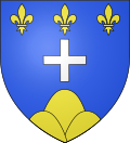 |
The arms of Argueil are blazoned : Azure, a cross couped argent between, in chief 3 fleurs de lys and in base a mont of 3 peaks Or.
|
Population
| Year | Pop. | ±% p.a. |
|---|---|---|
| 1968 | 389 | — |
| 1975 | 374 | −0.56% |
| 1982 | 395 | +0.78% |
| 1990 | 379 | −0.52% |
| 1999 | 366 | −0.39% |
| 2007 | 341 | −0.88% |
| 2012 | 335 | −0.35% |
| 2017 | 341 | +0.36% |
| Source: INSEE[3] | ||
Places of interest

- The church of St.Maurice, dating from the sixteenth century.
- The manoir d'Argueil, dating from the sixteenth century
- Some old houses and the remains of a donjon in the park of the chateau.
See also
References
- ^ "Répertoire national des élus: les maires" (in French). data.gouv.fr, Plateforme ouverte des données publiques françaises. 13 September 2022.
- ^ "Populations légales 2021". The National Institute of Statistics and Economic Studies. 28 December 2023.
- ^ Population en historique depuis 1968, INSEE
Wikimedia Commons has media related to Argueil.
| International | |
|---|---|
| National | |
| Other | |