
Deir Ez Zahrani
دير الزهراني | |
|---|---|
 | |
 Deir Ez Zahrani Location in Lebanon | |
| Coordinates: 33°25′52″N 35°27′34″E / 33.43111°N 35.45944°E | |
| Country | |
| Governorate | Nabatieh Governorate |
| District | Nabatieh District |
| Area | |
| • Land | 4.67 sq mi (12.09 km2) |
| Elevation | 1,300 ft (400 m) |
| Time zone | UTC+2 (EET) |
| • Summer (DST) | +3 |
Deir Ez Zahrani (Arabic: دير الزهراني) is a populated area in southern Lebanon. It is located 75 kilometres (47 mi) from Beirut.[1]
History
In 1875 Victor Guérin noted: "[Deir Zaharany is] located on a hill, has a population of 100 Métualis, to which must be added about twenty Christians. It succeeded an ancient locality, as evidenced by several fragments of scattered columns here and there and a number of ashlars embedded in a ruined mosque and in private houses. It was in one of these dwellings that was found in 1861, and brought back to the khan of Saida, an ancient funerary cippe, with palm, crown and lemnisque, and whose Greek inscription was reproduced by Mr. Renan."[2]
References
- ^ a b c Deir Ez Zahrani, Localiban
- ^ Guérin, 1880, p. 518: "A sept heures trente minutes, je poursuis ma route vers l'est-sud- est, el à huit heures vingt minutes je parviens à Deir Zaharany. Ce village, situé sur une colline, a une population de 100 Métualis, auxquels il faut ajouter une vingtaine de Chrétiens. Il a succédé à une localité antique, comme l'attestent plusieurs fragments de colonnes épars çà et là et un certain nombre de pierres de taille encastrées dans une mosquée en ruine et dans des maisons particulières. C'est dans une de ces habitations qu'a été trouvé eu 1861, ét rapporté au khan de Saïda, un ancien cippe funéraire, avec palme, couronne et lemnisque, et dont l'inscription grecque a été reproduite par M. Renan."
Bibliography
- Guérin, V. (1880). Description Géographique Historique et Archéologique de la Palestine (in French). Vol. 3: Galilee, pt. 2. Paris: L'Imprimerie Nationale.
- Renan, E. (1864). Mission de Phénicie (in French). Vol. 1. p. 523.
External links
- Deir Ez Zahrani, Localiban
| Capital | 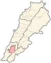 | |
|---|---|---|
| Towns and villages |
| |
| Other | ||