
KML is from Wikidata
Hereford | |
|---|---|
 HR | |
| Coordinates: 52°04′08″N 2°43′26″W / 52.069°N 2.724°W | |
| Country | United Kingdom |
| Postcode area | HR |
| Postcode area name | Hereford |
| Post towns | 6 |
| Postcode districts | 9 |
| Postcode sectors | 33 |
| Postcodes (live) | 6,387 |
| Postcodes (total) | 7,899 |
| Statistics as at May 2020[1] | |
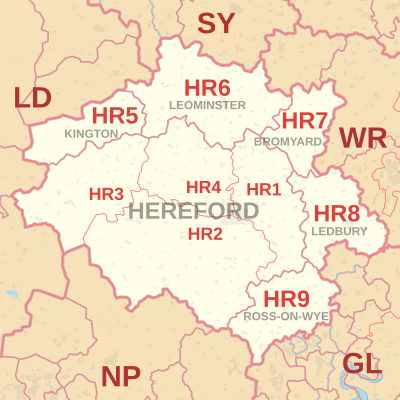
The HR postcode area, also known as the Hereford postcode area,[2] is a group of nine postcode districts in England and Wales, within six post towns. These cover most of Herefordshire, including Hereford, Bromyard, Kington, Ledbury, Leominster and Ross-on-Wye. The area also covers very small parts of Gloucestershire and Worcestershire, while the HR2, HR3 and HR5 districts extend across the border to cover a small part of Powys.
YouTube Encyclopedic
-
1/5Views:31 79633 30661 26357 521480 223
-
FATEHABAD PIN Code List || 129 post offices in Alphabetical Order. Haryana
-
Telephone Code Numbers from different cities in pakistan || (@wholeworlddata3577 ) | #telephone
-
Serviced Accommodation UK (10-hour course)
-
GURGAON PIN Codes List || 171 Post Offices in Numerical Order. HARYANA.
-
How to Reset Apple Watch (Too Many Passcode Attempts)
Transcription
Coverage
The approximate coverage of the postcode districts:
| Postcode district | Post town | Coverage | Local authority area(s) |
|---|---|---|---|
| HR1 | HEREFORD | Hereford (east) | Herefordshire |
| HR2 | HEREFORD | Hereford (south) | Herefordshire, Powys |
| HR3 | HEREFORD | Hay-on-Wye | Herefordshire, Powys |
| HR4 | HEREFORD | Hereford (west) | Herefordshire |
| HR5 | KINGTON | Kington, Lyonshall | Herefordshire, Powys |
| HR6 | LEOMINSTER | Leominster | Herefordshire |
| HR7 | BROMYARD | Bromyard, Edwyn Ralph, Stoke Lacy | Herefordshire |
| HR8 | LEDBURY | Ledbury, Bosbury, Bromsberrow, Hollybush | Herefordshire, Forest of Dean, Malvern Hills |
| HR9 | ROSS-ON-WYE | Ross-on-Wye, Gorsley, Gorsley Common | Herefordshire, Forest of Dean |
Map
KML is from Wikidata
See also
References
- ^ "ONS Postcode Directory Version Notes" (ZIP). National Statistics Postcode Products. Office for National Statistics. May 2020. Table 2. Retrieved 19 June 2020. Coordinates from mean of unit postcode points, "Code-Point Open". OS OpenData. Ordnance Survey. February 2012. Retrieved 21 April 2012.
- ^ Royal Mail, Address Management Guide, (2004)
External links
- Royal Mail's Postcode Address File
- A quick introduction to Royal Mail's Postcode Address File (PAF)
- Using Welsh alternative addresses within Royal Mail's Postcode Address File (PAF)